The ABC report boulders strewn across a road after storm waves and quote experts blaming sea level rise.
It seems that almost three years ago there were works extending a rock wall. Monthly sea level data from tide gauges at Portland and Lorne show that from about 2015-16 sea levels have fallen till the end of last year. We will look out for updated data – and there are a few missing months I can checkout but I wanted to present the raw data. Link to chart

Thanks for this.
I think those rocks are volcanic in origin from the nearby caldera of a former eruption….
Such volcanic rocks are full of ‘bubbles ‘ from being volcanic in origin.
So they can be moved by strong wave action ….they are not solid rock !
I think (I may be wrong) that Bass Strait is actually reducing in depth from some uplifting of the sea floor but also with sediment filling it up. I understand that large ships can no longer get into the harbour at Burnie (the ferry from Burnie to King Island no longer operates) and that the Devonport harbour has to be continually dredged to allow larger ships such as the Bass strait ferry, the Goliath (carrying cement), tankers, and cruise ships to dock or get close.
Ports on a river like Devonport could be expected to have sedimentation issues needing periodic dredging.
Re Burnie – maybe due to servicing larger vessels? On another issue – remember the research by the late great John Daly into the 1841 mean sea level mark cut on the Isle of the Dead at Port Arthur near Hobart. Parts 1 and 2 are linked here. Does anybody know of any developments in the measuring of the height of the 1841 mean sea level mark in the last decade?
here are links to BoM charts for Portland and Lorne
A key point is your reference to the extension of the rock wall. These local changes strongly influence sand beach erosion and accretion. Nearby examples are erosion at Narrawong after the construction of breakwaters at Portland. Fortunately we do have quality sea level data and the Portland/Port Fairy sites show no significant change in sea level over many years. Why the media cannot see through the catch all ‘blame it on climate change’ is beyond me.
I found the 75p pdf of a 2015 draft paper by seismologist Dr Kevin McCue –
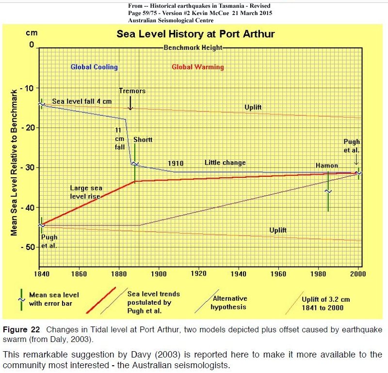
“Historical earthquakes in Tasmania – Revised” – Version#2 – 21 March 2015
I am sure Google will find it for you – On p59 he presents the attached diagram from the late John Daly (note typo- Davy = Daly).
My eye was caught by his implied praise for Daly under the chart. Larger chart.
The Australian plate is separate from the active global seismic zones and quakes are generally thought to be rare yet flickers of life hit the news at odd times like these off Fraser island in 2015.
Rare sight on USGS web page as Australia stars in global earthquake stakes
I had never heard of the Tasmanian earthquake swarm reported from the 1883/1892 as documented in “Historical earthquakes in Tasmania – Revised”.
Interesting that John Daly picked this up and noted the possible significance for his sea level research nearly 20 years ago.