Back when “Climate change” was worse in 1888, The Maitland Mercury and Hunter River General Advertiser Sat 8 Sep 1888
“CASSILIS,
On Saturday we were favoured with 53 points of
rain, which had the effect of allaying the numerous
bush fires raging around us of late, and replenishing
tanks, etc. A fall of three or four inches is much
needed to do any good. Farmers are now ex-
periencing harder times than have been known in
these parts for years. Wheat crops are all a
complete failure, and in most places not making
an appearance above the ground.”
In the cooler cherry growing area of Orange N.S.W.”ORANGE, Tuesday August 28 1888.
The heat in Orange to-day (Tuesday) is sufficiently
great for mid- summer. A heavy haze of smoke encircles
the town, caused by the smoke of bush-fires which have
been burning on the Rosedale estate, to the north, since
Sunday. Spring flowers are out, and trees are putting on
foliage, yet we cannot realise that winter is only leaving us,
Thanks Ian. I have not got time to spare digging into Trove.
And Siliggy – I was hoping your experience searching Trove would find more examples.
BUSHFIRES IN QUEENSLIAND HUGE AREA COVERED.
Bush fires have occurred in the central and western country, covering a huge area, and causing widespread damage. A large number of sheep are believed to have perished.
The Central Queensland Herald 30 Sep 1948
Coastal Bushfires
An 800-mile chain of bushfires fed by dry grass stretched tonight along the Queensland coast from Cairns to Maryborough. Some North Queensland towns were almost completely encircled by fires, The ANA pilot who flew over the area tonight said that the blaze on ranges behind Townsville sent black smoke curling 3000 feet into the air.
The Queensland chapter of “Understanding bushfire: trends in deliberate vegetation fires in Australia” provides a bit of bushfire history (p10), including an interesting July/August 1941 bushfire that destroyed 120,000ha around Julia Creek, Barkly Tableland, Richmond and Cunnamulla. Three historic September bushfires in Queensland are referenced.
I’ve no evidence to dispute that the current bushfires have burnt through a record area for September, but it’s worth arguing about these being the earliest ever Queensland bushfires. I’m ignoring other questions including how they knew about the existence or size of big bushfires a hundred years ago, Queensland’s population 750,000 in 1919 vs 5.1 million in 2019, and the fact that arson wasn’t such a popular hobby a hundred years ago.
Thanks for that information, Warwick. I’d been (somewhat idly) wondering about those issues for about 20 years – since the time a successful high-wind arson episode came close to wiping my family and home out.
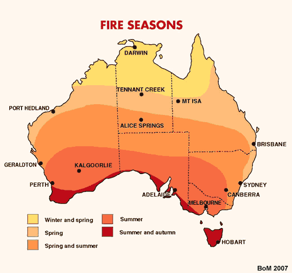
Warwick useful chart of fire seasons thanks.
This may add to that data.longpaddock.qld.gov.au/static/products/pdf/WetDryDroughtPoster.pdf
Bushfires are more likely in a period of dry seasons. As can be seen wet and dry periods alternate and last about 7 years. We have been in a dry period for 7 years so it is extra dry and fires will quickly spread if lit (arson or carelessness,) Note the IPO on the chart. Nothing to do with CO2 emission.
The previous dry period 2001-2007 (actually should be 2008) was followed by a wet period in which there were floods in the SE Qld (including deaths) in 2011. IPO and SOI not good at present. One hopes both will turn before the end of December.
It is my long-term (but anecdotal) observation that bushfires deliberately lit – arson – occur when high westerly or north-westerly winds are running in spring or summer after a dry winter.
This is because of the crowning effect, I suggest. That is, the arsonist achieves the “thrill” (and thrill for them it is) in watching the firefront tearing from clump to clump, ignited debris pushed by the high wind, eucalypts exploding as their flammable vapour ignites.
No, I do not find that funny. I’ve experienced the results of just such a pathology. Within 50m of my family and home.
So high westerly, or worse north-westerly, winds in spring or summer are periods of high arson danger.
Ian you may be right for winds in Victoria and Tasmania (eg 1967 fires) but the winds at Peregian Beach were from the south due to a high over Victoria and a low in the Tasman sea towards NZ. We know a person at Coolum beach who has lung problems and is on a oxygen respirator. She could see the fires at Peregian to the north and was glad the smoke and fires were heading north.
Do not know about the fires at Stanthorpe but looking at weather charts I am sure the winds were from the south. In Summer the winds (cyclones) come from the east bringing normally rain.
As for bush fires starting earlier or later, it used to make the news if they ever stopped. That is if you don’t count grass fires.
October 12 1951
The headline reads ” No Bush Fires”
Then “Forthe first time this year therewere no bush fires in Queensland to-day. Light rain was
falllng over two-thlrds of the
State to-night.”
However it is a bit misleading because they were only able to say there were no Bush Fires by drawing a distinction between bush fires and grass fires.
“Kholo Grass Fire
About 40 acres of grass were
burnt in a fire near the Kholo
reservoir early yesterday after
noon.” trove.nla.gov.au/newspaper/article/118220877
Cementafriend
Yes, it does indeed depend where on the geographical periphery of the high one is, given a continent-wide high/low pressure boundary wind runs anti-clockwise.
The W/NW wind direction holds for the south and south-east of the continent as being the dangerous one for arson. The north of the continent, yes, south is then the danger.
I agree, south-east wind directions for the eastern coasts generally bring rain, blowing in moisture from the Pacific.
Nonetheless, it is no coincidence that all those fires ignited almost simultaneously when a period of very high winds set in, with no dry lightning. Here in the south-east of the continent, we experienced hard, high, gale strong westerlies for over a week, day and night without break. This put me on edge, as it were, since I know this excites the arsonists.
Sorry, I also meant to point out that the smoke streams from the fires as tracked and photographed from the satellites, extended in almost straight lines W-E across the Pacific.
Thanks Warwick, I posted on Australian Climate Sceptics Facebook page.
Emailed in by Siliggy adding some context to Campbell Newmans headlines above from 16Aug1953.
This from 18Aug1953 in addition to “bushfires rage near the Queensland coast” – records “snow in 5 States” – in “South Australia heaviest snow on record” – “in Vic the Ovens River near Wang burst its banks” – “people stranded in snow in NSW Alps” – “hundreds of lambs die around Molong” – all a poets dream. But society forgets our history.
Leave a Reply
Primarily exposing faulty methodologies behind global temperature trend compilations

Warwick,
Here’s another Bushfires worst in Q’land History, although a little later in the year than the August ’46 one.
And I’m sure there are others.
Back when “Climate change” was worse in 1888, The Maitland Mercury and Hunter River General Advertiser Sat 8 Sep 1888
“CASSILIS,
On Saturday we were favoured with 53 points of
rain, which had the effect of allaying the numerous
bush fires raging around us of late, and replenishing
tanks, etc. A fall of three or four inches is much
needed to do any good. Farmers are now ex-
periencing harder times than have been known in
these parts for years. Wheat crops are all a
complete failure, and in most places not making
an appearance above the ground.”
Before September even started places further south than current events were suffering in 1888.
Camden, Carcoar, Canownindra and towns beginning with other letters.From Braidwood the description was “The weather now looks broken”.
Ooops that Braidwood one here.
In the cooler cherry growing area of Orange N.S.W.”ORANGE, Tuesday August 28 1888.
The heat in Orange to-day (Tuesday) is sufficiently
great for mid- summer. A heavy haze of smoke encircles
the town, caused by the smoke of bush-fires which have
been burning on the Rosedale estate, to the north, since
Sunday. Spring flowers are out, and trees are putting on
foliage, yet we cannot realise that winter is only leaving us,
Thanks Ian. I have not got time to spare digging into Trove.
And Siliggy – I was hoping your experience searching Trove would find more examples.
As with the current "unprecedented" Queensland bushfires, the "Hundreds Of Miles Ablaze" of August 1946 was preceded by drought. Perhaps not as severe as the current drought, but drought nonetheless.
The West Australian 3 Sep 1908
BUSHFIRES IN QUEENSLIAND HUGE AREA COVERED.
Bush fires have occurred in the central and western country, covering a huge area, and causing widespread damage. A large number of sheep are believed to have perished.
The Central Queensland Herald 30 Sep 1948
Coastal Bushfires
An 800-mile chain of bushfires fed by dry grass stretched tonight along the Queensland coast from Cairns to Maryborough. Some North Queensland towns were almost completely encircled by fires, The ANA pilot who flew over the area tonight said that the blaze on ranges behind Townsville sent black smoke curling 3000 feet into the air.
The Queensland chapter of “Understanding bushfire: trends in deliberate vegetation fires in Australia” provides a bit of bushfire history (p10), including an interesting July/August 1941 bushfire that destroyed 120,000ha around Julia Creek, Barkly Tableland, Richmond and Cunnamulla. Three historic September bushfires in Queensland are referenced.
aic.gov.au/sites/default/files/publications/tbp/downloads/tbp027_04_qld.pdf
I’ve no evidence to dispute that the current bushfires have burnt through a record area for September, but it’s worth arguing about these being the earliest ever Queensland bushfires. I’m ignoring other questions including how they knew about the existence or size of big bushfires a hundred years ago, Queensland’s population 750,000 in 1919 vs 5.1 million in 2019, and the fact that arson wasn’t such a popular hobby a hundred years ago.
More useful finds Chris thanks –
I downloaded the Qld pdf of the Australian Institute of Criminology report – Understanding bushfire : trends in deliberate vegetation fires in Australia by Colleen Bryant Jan2008 there are pdf’s for all States.
She has a map on page 10 but the colouring has degraded. I found the original at the BoM.
So the current fires are in the zone for spring fires.
Thanks for that information, Warwick. I’d been (somewhat idly) wondering about those issues for about 20 years – since the time a successful high-wind arson episode came close to wiping my family and home out.
Campbell Newman reminds us of this news from August 1953.
Bushfires rage over S.E. Q’Land
twitter.com/CampbellNewman/status/1170630095918075904/photo/1
Warwick useful chart of fire seasons thanks.
This may add to that data.longpaddock.qld.gov.au/static/products/pdf/WetDryDroughtPoster.pdf
Bushfires are more likely in a period of dry seasons. As can be seen wet and dry periods alternate and last about 7 years. We have been in a dry period for 7 years so it is extra dry and fires will quickly spread if lit (arson or carelessness,) Note the IPO on the chart. Nothing to do with CO2 emission.
The previous dry period 2001-2007 (actually should be 2008) was followed by a wet period in which there were floods in the SE Qld (including deaths) in 2011. IPO and SOI not good at present. One hopes both will turn before the end of December.
It is my long-term (but anecdotal) observation that bushfires deliberately lit – arson – occur when high westerly or north-westerly winds are running in spring or summer after a dry winter.
This is because of the crowning effect, I suggest. That is, the arsonist achieves the “thrill” (and thrill for them it is) in watching the firefront tearing from clump to clump, ignited debris pushed by the high wind, eucalypts exploding as their flammable vapour ignites.
No, I do not find that funny. I’ve experienced the results of just such a pathology. Within 50m of my family and home.
So high westerly, or worse north-westerly, winds in spring or summer are periods of high arson danger.
Ian you may be right for winds in Victoria and Tasmania (eg 1967 fires) but the winds at Peregian Beach were from the south due to a high over Victoria and a low in the Tasman sea towards NZ. We know a person at Coolum beach who has lung problems and is on a oxygen respirator. She could see the fires at Peregian to the north and was glad the smoke and fires were heading north.
Do not know about the fires at Stanthorpe but looking at weather charts I am sure the winds were from the south. In Summer the winds (cyclones) come from the east bringing normally rain.
As for bush fires starting earlier or later, it used to make the news if they ever stopped. That is if you don’t count grass fires.
October 12 1951
The headline reads ” No Bush Fires”
Then “Forthe first time this year therewere no bush fires in Queensland to-day. Light rain was
falllng over two-thlrds of the
State to-night.”
However it is a bit misleading because they were only able to say there were no Bush Fires by drawing a distinction between bush fires and grass fires.
“Kholo Grass Fire
About 40 acres of grass were
burnt in a fire near the Kholo
reservoir early yesterday after
noon.”
trove.nla.gov.au/newspaper/article/118220877
Cementafriend
Yes, it does indeed depend where on the geographical periphery of the high one is, given a continent-wide high/low pressure boundary wind runs anti-clockwise.
The W/NW wind direction holds for the south and south-east of the continent as being the dangerous one for arson. The north of the continent, yes, south is then the danger.
I agree, south-east wind directions for the eastern coasts generally bring rain, blowing in moisture from the Pacific.
Nonetheless, it is no coincidence that all those fires ignited almost simultaneously when a period of very high winds set in, with no dry lightning. Here in the south-east of the continent, we experienced hard, high, gale strong westerlies for over a week, day and night without break. This put me on edge, as it were, since I know this excites the arsonists.
Sorry, I also meant to point out that the smoke streams from the fires as tracked and photographed from the satellites, extended in almost straight lines W-E across the Pacific.
Thanks Warwick, I posted on Australian Climate Sceptics Facebook page.
Emailed in by Siliggy adding some context to Campbell Newmans headlines above from 16Aug1953.
This from 18Aug1953 in addition to “bushfires rage near the Queensland coast” – records “snow in 5 States” – in “South Australia heaviest snow on record” – “in Vic the Ovens River near Wang burst its banks” – “people stranded in snow in NSW Alps” – “hundreds of lambs die around Molong” – all a poets dream. But society forgets our history.