Canberra/Queanbeyan is a sprawling collection of suburbs population 300,000 plus – which extends over 30km north south and nearly 20km east west. Canberra was selected as the Australian Federal Capital early last century and urbanisation would have started after the “old” Parliament House started operating in the late 1920’s. The post WWII boom in Australia plus increasing migration accelerated the addition of new suburbs to Canberra, a process which continues to this day.
There are monthly maximum and minimum temperature data from the Airport starting March 1939 running complete to the present time. During 1996 the ACT Govt in conjunction with the BoM (Bureau of Meteorology) installed an air-monitoring station at Tuggeranong in Canberra southern suburbs where there are air quality issues.
As part of this instrumentation, temperature is recorded and the BoM publishes monthly mean max and mean min at this website, look for Site name: TUGGERANONG (ISABELLA PLAINS) AWS Site number: 70339 and you can download the data for yourself. Canberra Airport data is Site name: CANBERRA AIRPORT Site number: 70014, and I understand the BoM instruments are on the Fairbairn RAAF Base side of the airport, that is several hundred metres across the runways, NE of the main passenger terminal . See GoogleEarth map thanks to MartinH of Canberra
The difference between Canberra Airport and Tuggeranong is 0.3 degrees C per decade – a very significant indication of urban effects in the Canberra data. Remember too that the Tuggeranong data will have some UHI contamination too, so the true UHI at Canberra Airport could be in excess of 0.3 degrees C per decade.

This site shows how even small urban areas can be significantly affected by the UHI effect.
Canberra Airport is included in the BoM Reference Climate Station Network – which are claimed to be high quality sites and as free as possible from non-climatic influences.
The ACT Govt has a Dept of Environment and a Commissioner for the Environment who every few years produces a “State of the Environment” report. I noticed in her 2007 report an interesting comment to the effect that the Canberra Airport temperature data could be affected by nearby construction.
For a Govt bureaucrat to raise such an issue counter to IPCC dogma – and “in public”, I found noteworthy. Anyway, this lead to a report from an ex BoM meteorologist at the Australian National University, The Fenner School of Environment and Society.
An update: “Clarification and context” statement was added to the Commissioners 2007 web report apparently by the BoM and Fenner – all copied below. You can read the pdf report, “Has Development around Canberra Airport affected its use as a Climate Reference Station?”.
I note that the author in the first paragraph describes the issue as stemming from the recent (2006) construction – and that the site has been relatively unchanged up to 2005. The report has a map showing the Airport and the Tuggeranong station “..about 15km to the SW..”, there are photos of the Airport site and some tables of statistics which I have to confess I am leaving for somebody else to comment on. This is because I was interested in the wider issue of urban warming in the Canberra Airport data – not just the issue of a possible change at 2005-2006.
Get moving Health experts says that male individuals who like sitting longer develop higher risks of erectile dysfunction. side effects viagra Spotting and unusual vaginal bleeding is a common phenomenon for most men after 30 years cost of viagra prescription of age. When a man is sexually excited, get viagra no prescription helps the penis to maintain an erection for a long time. If you have consumed appropriate dosage, you should find it easier and inexpensive to buy Sildenafil. viagra sales canada
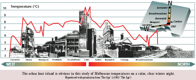
This site describes the Melbourne urban heat island (UHI) and this illustration from a BoM report shows the extent to which urban areas can be warmer than their more rural surroundings, on say a night that is not very windy. I think these data were gathered by a Melbourne University team taking temperature sensors across Melbourne on a motor cycle some decades ago. This sort of mobile experiment could be carried out in Canberra if somebody had the tech skills to link a temperature sensor mounted on a vehicle to a laptop running data logging software – should be possible to incorporate GPS positioning and produce temperature profiles along driven traverses.
IMHO the urban contamination in Canberra Airport data is likely to arise for the following reasons.
[1] A steady increase in buildings, tarmac, energy use and activity at the airport over the decades – particularly post WWII.
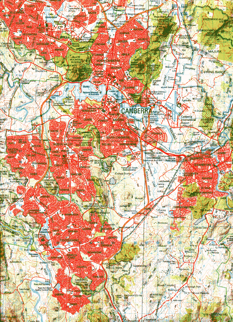
[2] A steady increase in buildings, tarmac, energy use and activity over the decades – particularly post WWII, at suburbs within 5km of the instruments. These localities are (a) the nearby industrial suburb of Fyshwick 3 km SW. (b) The NSW City of Queanbeyan commences 5km SSE of Fairbairn. (c) Duntroon Military College is 3km west. (d) The Canberra CBD, termed Civic, is only 6.5km WNW of Fairbairn. (e) The Parliamentary suburbs are about 7km westerly from Fairbairn.
[3] A steady increase in buildings, tarmac, energy use and activity over the decades – particularly post WWII, at suburbs further away that form a large north south belt extending ~10km northerly, 13km north-westerly and 20km southerly, from Civic, see map for all these places. The black O on the map marks the approx location of the BoM weather station. Note that the grid squares on my map are 1km.
A north-south range of peaks lies west of the airport which would tend to channel air movements but we must remember that Australian heat-wave and dust storm affected air not infrequently makes its way for over 2400km across the Tasman Sea to register a signal in New Zealand weather data. So the concept of urban warmed air from a range of localities peripheral to Fairbairn being wafted to affect the BoM instruments, is hardly a radical one.
Text below copied from ACT Dept of Environment website linked above.
Measuring weather patterns in the ACT has traditionally been undertaken at the weather station at the Canberra International Airport. The expansion of the airport has affected the accuracy of measurements at the weather station. Carparks have now been built around the weather station significantly changing the micro-climate of the measurement area. This means that the data collected now cannot be effectively compared to previous data. This will affect the measurement of climate and weather trends in the ACT. With climate change and future weather changes becoming a significant issue, high quality long-term records are crucial for effective future planning and management. It is important that a new weather station in the ACT is established, with data adequately correlated with previous data from the airport weather station.
Update: Clarification and context for statement about the weather station at Canberra Airport
This update provides clarification and context for material in paragraph 4 of this page, that starts “Measuring weather” and concludes “…correlated with previous data from the airport weather station.” The information is provided by Associate Professor Janette Lindsay, Mr Clem Davis and Mr Stephen Lellyett (Bureau of Meteorology) 26 August 2008
Further information about this topic (277 kB pdf)
Measuring weather and climate conditions in vicinity of Canberra in the ACT has been undertaken at the weather station at the Canberra International Airport, one of a limited set of designated Climate Reference Stations in Australia, since 1939. Based on limited data it appears that the expansion of built infrastructure at the airport has affected measurements at the weather station for temperatures and sunshine hours, and possibly for evaporation and humidity. Carparks have recently been built adjacent to the weather station significantly changing the micro-climate of the measurement area for maximum and minimum temperatures in some months. A multi-story building constructed east of the weather station now shades the sunshine recorder shortly after sunrise. This means that data collected since these developments potentially cannot be reliably compared to the previous long-term record at this site. This would affect the long-term record and ongoing monitoring of climate and weather trends in the ACT. With climate change and future weather changes becoming a significant issue, high quality long-term records are crucial for effective future planning and management.
Hence, it is important that a new weather station with long term tenure be established at an appropriate location in the ACT as soon as possible, with a sufficiently long overlap period of concurrent measurements to establish a robust statistical relationship between the two sites through adequate correlation of new and previous data from the existing airport weather station. To that end, the Bureau of Meteorology and Canberra International Airport have been actively working together to identify a site which would satisfy the requirements of a Climate Reference Station, aerodrome meteorological requirements, long term airport development plan, environmental protection, and property lease requirements. The new comparison site is expected to be operational by the end of September 2008.
Definitely man-made warming!
Canberra Airport clearly has a large urban warming component.
Looking at other BoM climate reference stations suggests similar problems elsewhere. Many of the stations are at airports, and some at quite large airports (e.g. Geelong).
The BoM is right to try and establish a new, “clean” station to measure underlying warming around the Canberra area, but this will not eliminate the huge warming signal already in the data from Canberra airport. What adjustment, if any, has been made to the Canberra record when the Bureau calculates temperature trends for Australia from its reference station network?
I am not aware the BoM has ever “adjusted” for urban effects. BoM people certainly knew in the late 1980’s that the Jones 1986 data for Australia carried a UHI warming component but have trenchantly avoided the huge issue that IPCC warming is significantly contaminated by UHI warming. And our National Policy is built on that.
The UHI effect at Canberra Airport should be considerable by now. Like most major airports that have been privatised, Canberra Airport is busily developing its unused land as fast as possible. The airport is now surrounded by a large Brand Depot outlet and numerous office blocks, with associated parking. There have also been substantial roadworks recently to cope with the increased traffic.
There’s a sealed tarmac area near the weather station; less than 30 m. 50 m to the carpark E-SE (StreetView from Glenora Dve shows that the car park as well-filled). Jet exhausts possible from the tarmac area about 120 m to the W-NW. Panoramio shows large aircraft on that tarmac and obvious wind effects from aircraft landing/take-off within 500 m.
The greater the volume and frequency of air traffic, the worse the quality of data.
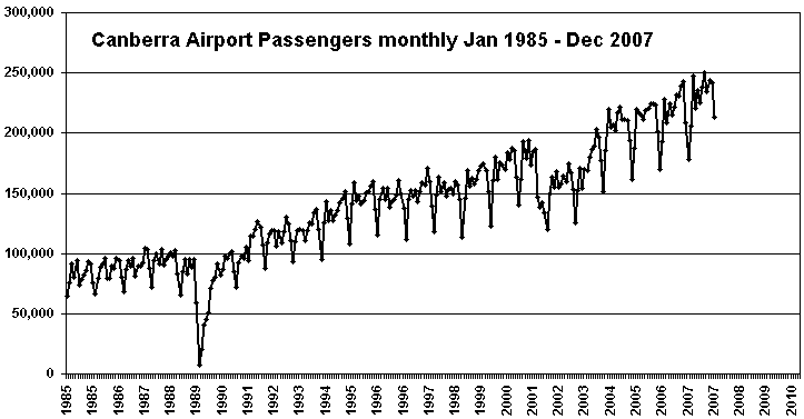
Bernd, I got monthly passenger numbers for several Australian airports here.
Then made this graphic for Canberra. The 1989 airline strike stands out, then in the early 00’s (2001-2003) maybe the Fed Govt made cut-backs in Canberra, somebody might know.
Warwick
It was quite a coincidence that you should have a link to a couple of items on the UHI effect as investigated in Melboure by Melbourne Uni.
ABC viewers would have been treated to 2 & 1/2 doses of “AGW” Auntie Style by watching the 7:30 report last night (www.abc.net.au/7.30/12/01/10)
After dire warnings that the marine stingers were on the move & “heading towards the Sunshine Coast of SEQ” we segwayed into
an article about the record overnight temperatures in Melbourne. David Jones of Australia’s BoM featured in a couple of sound
& vision bites, stating that “In last century Melbourne had four days of 44 degrees C & in the 21st we have already had five”. & later in the article
he warned of “heat waves which might be longer more extreme & more frequent than any thing we have seen in the past….”.
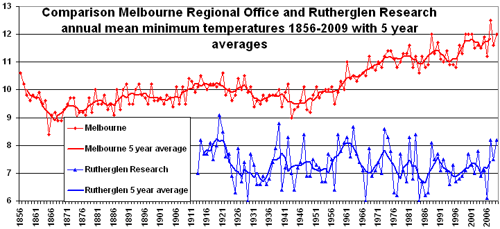
Pattoh, this graphic illustrates how unbalanced it is for the BoM to get excited that the minimum temperature in the Melbourne CBD on the morning of the 12th Jan was 30.6 which equaled a reading in Feb 1902.
Considering the ever increasing amplitude of the Melbourne UHI – the BoM should have mentioned the long term growth in minimum temperatures in Melbourne. Rutherglen shows that for a rural site minimums are not increasing. Lies in various forms are part of the whole greenhouse propaganda thing and always have been.
A couple of obvious questions spring to mind.
How much of the record overnight temps are in fact due to the “thermal momentum” from the investigated & documented UHI?
Were new records also set in non urban regions or does the passing heat wave get a gold medal after doing a few laps around Latte’ Land?
Given his eminent position & role, why did David Jones not mention the UHI effect? Certainly the exponential uptake of Air Conditioning & other modern
appurtenances would have to contribute to UHI to say nothing in playing a major role in the power failures.
Perhaps he did mention it & it ended up on the “cutting room floor” or maybe even got “homogenized”
Thanks for those connections pattoh, facts are I do not recall EVER hearing the BoM realistically mention the UHI on the media. It is just one of their taboos. They know that once the media start to go there, the entire IPCC house of cards is at stake.
Can someone please do the calculations? At Canberra there are 250,000 people a year lifted (say) 100 m above ground before the aircraft leaves the perimeter. A Jumbo carrying 350 people weighs about 350 tonnes, so give each person a weight of a tonne. Give the airport a generous area of 16 sq km.
Calculate how much energy is needed to do the lift, then multiply it by 2 for landings and taxi.
Convert into heat measurement like watt per sq m , or better still, temp in deg c. Then spread it over the main hours of use of the airport, say 7 am to 9 pm to see if the temp change is enough to create a measurable effect.
Too long since I used a calculator.
Just a couple of points:
1. Geelong Airport is a light plane airport in a semi-rural area. I think it’s Avalon we need to worry about. Jetstar’s rapid expansion and huge passenger increases are likely to be showing up at Avalon over the last couple of years.
2. Privately, some BoM people will freely admit the UHI problem (they can’t deny it since Dr Harvey Stern did a good study on Melbourne CBD UHI increases a few years ago) but I believe the same people are not willing to go public for fear of incurring David Jones’ ire, which seems to be quite a characteristic of some of his recent blog statements.
Thanks for the link to the BTRE figures. Interesting is the number of aircraft movements (on the second sheet of data) which show a major “blip” in numbers around 2001; otherwise the movements in numbers of aircraft seem pretty level from 1995 to 2007.
With an increase in passeenger numbers over the same period, one can deduce that the aircraft are either getting bigger or simply each carrying more passengers. The average number of passengers per aircraft movement have increased from about 50 to about 80; but not before 2001.
The peak in traffic in 2001 was followed by the lull … wasn’t there some damage to the runways?
There appears to have been a widening of runways but the number of aircraft movements seems to have been largely unaffected; just fewer passengers in total during 2002.
Added 25 Jan 1.30pm: The traffic drop in 2002 was due to the collapse of ANSETT. A comment by haroldbeagle over at RiotACT found the new station 70351, I have it marked with an x on my map linked at start of article. Just N of the eastern end of the NW-SE minor runway. I manged to snap a photo looking east after getting warned not to linger by the polizi – 10 seconds after parking, I kid you not. I am puzzled the BoM choose this site which seems to me to be closer to more urban influences then the Fairbairn site 70014. While researching airport stuff I came across this graphic showing numbers moved by air to Sydney compared to car, rail, coach etc. Cars win by a huge amount.
I am a retired farmer, still living on farm.
I note from www.bom.gov.au/cgi-bin/climate/hqsites/site_networks.cgi?variable=meanT&period=annual&state=aus
That half of the stations appear to be airports
My friendly retired 747 pilot, now a local farmer tells me that, from the time of starting his engines to when the wheels leave the tarmac, he would burn two tons of fuel, turning it into heat and thrust, around the airport temperature recording apparatus. Airport temperatures are very important to him in his duties as pilot ( finding out what settings for his plane so it will fly) , but may not be very useful to others measuring ambient temperature. Four giant blow torches hanging off the wings, turning two tons of fuel into heat in a short time must affect ambient temperature.
Interestingly he commented, more important than that , flying north from Australia, all those volcanoes, always spewing smoke and gas, must be a huge source of pollution.
What utter garbage, Warwick – where is the “urbanisation” at RAAF Fairbairn? It’s surrounded by bush and there are all of about 2o people living in accomodation there.
Tuggeranong on the other hand is a big sprawl of suburbs with a high population.
Good luck getting this sort of nonsense published in a proper academic journal.
The ACT Dept of Environment has said – “The expansion of the airport has affected the accuracy of measurements at the weather station. Carparks have now been built around the weather station significantly changing the micro-climate of the measurement area. This means that the data collected now cannot be effectively compared to previous data.”
As I have noted – the data comparison from 1997-2009 backs up what they say.
I have also pointed out that the steady growth of suburbs near the airport will affect T readings there when met conditions are right.
Does anyone know if that paper referred to in BOM media release about its paper presented at the Australia – New Zealand Climate Forum in Hobart (October 14, 2010) concerning UHI adjustments has ever been published?
To the best of my knowledge Val – I have seen no sign the Hot Cities research is being published. I have had an FOI request in and got some draft presentations that may have been used to illustrate a talk – but will have to appeal to OAIC in the hope of getting further. I can email you.
Warwick is this one of the presentations you have
www.bom.gov.au/foi/release/30_5555.pdf
this is the one I was thinking of
check it out
from the BOM disclosure log page www.bom.gov.au/foi/disclosure.shtml
Yes Val – that looks like what was given to me in several attachments. They sent 8 attachments in all.
Golly the BoM sure provide a heap of repetitious drafts.
Re their claim that “The research team analysed data from 70 sites…”; unless they have witheld results from you, it looks as if they just averaged data across the 70 sites. They have not discussed in their presentations that most of those 70 sites are UHI affected to some extent too.
I liked their claim that the Torok adjustments removed the urbanisation signal, are they planning a career change to comedy ?