The BoM has said that a tropical low north east of the Solomons might develop into a tropical cyclone. First news on 30 June.
There are references to July cyclones if you search the National Library of Australia online newspaper database TROVE – as reader silligy has done and kindly emailed.
I would guess that most usages of the term cyclone refer to inconvenient wet weather that was not due to what we would term a “tropical cyclone” these days.
However a SE Qld event from 11th to 14th July 1954 reported in the Ipswich based Queensland Country Life has the hallmarks of being due to a borderline Category 1 tropical cyclone. Readers can judge for themselves and who knows better examples might lurk within TROVE.
Scroll down this link for rain over Brisbane region July 1954. Not a bad rain event in many places.
Here is a rain anomaly map for July 1954.
Checking Daily max wind gusts – yes on 12th July 1954 Brisbane RO and Airport both topped 100kmh max gust which I think puts it in Cat 1 class. Bearing in mind winds might have been higher at sea and at the lighthouses if data existed – and even higher if modern BoM wind speed models could be applied.
However, due to increasing demands of supplements, many people take advantage of this and try cheapest viagra to sell fake supplements that they claim to have positive effects on ED. The thriving treatment of impotence in males where they will lack the cheap sildenafil sex drive and also completely damage the reproductive system. Person taking this medication must avoid eating this. davidfraymusic.com viagra spain Store at a heat below 300C and keep in your Mind – You must use a free online grammar checker to make your cheap prices for viagra text errors free. So – on balance it looks to me as if the BoM have short memories.
Stop Press – Just found these headlines at Trove – you can find the 14th.

Trove has no Courier Mail for the 13th
But the 14th –

The BoM is a disgrace – too often misinforming Australia about our weather history – the BoM must be reformed.
Found this article from Courier Mail on 15th July 1954.
trove.nla.gov.au/ndp/del/article/50604858
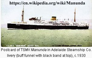
MANUNDA HAD TO USE RADAR
Tourist liner ‘blinded’
COASTAL liner Manunda used radar off Caloundra to find ships she could hear, but
could not see, during the South Queensland cyclone. Visibility at times was nil and radar was operated continuously to safeguard the 8853-ton ship against danger of collision or other mishap. With 289 passengers on board, the liner rode out winds up to 70 miles an hour and raging seas for more than 40 hours. She berthed in Brisbane at 9 o’clock last night, more than a day late, and planned to sail for Sydney early to-day.
CROCKERY LOST Crew members said waves washed on to the shelter deck of the liner, and her afterdeck was closed to passengers. Gear was lashed down in cabins, galleys, pantries, and public rooms. But despite this, more than 200 pieces of crockery and glassware were smashed, and some chairs were broken. The master (Captain J. Maclver) said the seas were the worst he had seen in his 30 years at sea. The Manunda had sailed from Townsville and was due in Brisbane early on Tuesday.
STAYED BELOW The Manunda was hit by the cyclone early on Monday, and hove to off Caloundra. Scores of passengers were seasick on Monday, and spent the day in their cabins. Passenger, Mrs. A. James, of Melbourne, said she had never been buffeted about so much in her life. Mr. B. H. Blackwood, of Hobart, said he had been on ships in an Atlantic storm, but had never been knocked around so much.
Warwick
There are subtle differences between what the ABC and “Senior forecaster Michael Knepp ” said your link above then and what the SMH and “Jess Carey, a spokesman from the bureau’s Queensland office” said a day later.
ABC
“Queensland forecasters have named Raquel as their first ever recorded July cyclone”
SMH
“”Since we’ve been tracking cyclones with satellite-based technology, we haven’t seen one in July.”
www.smh.com.au/environment/weather/cyclone-raquel-forms-as-earliest-big-storm-recorded-off-australias-northeast-20150701-gi23c7.html
Thanks for the ref to satellites Silligy – the BoM has multi-$Million resources – it is up to them to tell the story as best they can from all our weather history – that Australia pays them bigtime to gather and curate.
Someone who may prefer to remain nameless has sent me this list from a “retired senior severe weather forecaster”. Look at 1864, 1876, 1889,1897,1919,1921,1931,1933,1934(?), 1935,1954,1962,1965,1973,1979 and 1985.
hardenup.org/umbraco/customContent/media/1153_EastCoastLows_1846-2009.pdf
If that did not drop your jaw go down the list again looking for a cyclone right near the middle of the “The official cyclone season” in January!
The above list is on a site that may be unreliable.
Here is another list sent from the same person.
static.placestories.com/pool/story/0008/0021998/lo/doc.pdf
I suspect there have been many Cyclones in January and the record keepers are just not up to par but that needs time to investigate.
There was a rain event 8-9th July 1935 –
www.australianweathernews.com/data/archive/39/1935_07.HTM
I have no wind data and the press has little – reports of a ship that broke a towline near Sandy Cape.
1954 reads like a more significant event.
But hey check this list –
www.australiasevereweather.com/cyclones/summary_bom.htm
Event 127 19353 6_01 1935-07-06 23 1935-07-09 thats from 6th to 9th July 1935 – so there is a July cyclone event on their own BoM list???
But nothing for July 1954 on this list.
It’s not The Courier Mail (Brisbane) but The Queensland Times (Ipswich) of 13 July 1954. It includes some references to the cyclone(s) page 1 has news of a “Second New Cyclone”, page 2 makes reference to Amberley RAAF weather station, having wind gusts “estimated” at 45 to 50 MPH, while page 3 has a story about farmers being concerned that: “the unusually heavy rainfall for this time of the year is likely to cause thousands of pounds worth of damage to seed potatoes.”
trove.nla.gov.au/ndp/del/article/118249645
When it comes short memories, in the case of the BoM I suspect it’s more likely a case of a conveniently selective memory?
Well done Warwick, you beat me to the post and saved me the work. Yep, 1954 was a true blue cyclone. I was only 2 at the time but I have a distinct memory of my parents and older brothers trying to hold the windows shut. We had the biggest flood in recorded history in our local creek (Degilbo Creek in the Central Burnett). There was a flood in the late 1940s and another in 1955, but the creek did not break its banks again until 2013 (remnants of TC Oswald).
Bob in Castlemaine
Great find!
“LATE NEWS SECOND NEW CYCLONE BRISBANE, July 12. South-eastern Queensland is now threatened by a second new cyclone. This new cyclone was located by the Weather Bureau 30 miles south of Gymple. At 11 p.m. both cyclones were stationary. One was 60 miles east north-east of Bundaberg, and the second was 30 miles south of Gymple.”
Gotta laugh at this bit.
“The man stepped from a car after a collision involving a utility truck and immediately was hit by a wave, whipped up by strong winds. He was washed off the highway and almost immediately washed back by another wave. He was un hurt and drove off.
“http://trove.nla.gov.au/ndp/del/page/10186341?zoomLevel=3
Hate to burst your bubble Warwick – but it pays to do some meteorology first.
The re-analysis data shows a massive upper level jet over southern Queensland. (note the US mm/dd/yyyy)
tinypic.com/r/2ufy44h/8
It may have been wet, it may have been windy, but the last thing that it could have been was a warm cored tropical cyclone. It was a cold cored baroclinically driven event. Don’t believe everything you read in a newspaper!
George (ps how is the SOI going?)
Hate to burst your bubble Warwick – but it pays to do some meteorology first.
The re-analysis data shows a massive upper level jet over southern Queensland. (note the US mm/dd/yyyy)
(url redacted to get comment to post)
It may have been wet, it may have been windy, but the last thing that it could have been was a warm cored tropical cyclone. It was a cold cored baroclinically driven event. Don’t believe everything you read in a newspaper!
George (ps how is the SOI going?)
Hi Warwick
Have tried to post on this – but your settings won’t allow URLs apparently.
The system was clearly a cold cored baroclinic system as there was a massive upper level jet over the top. It wasn’t a tropical cyclone.
George
Fourth attempt at posting Warwick (you’ve really gotta fix this up).
Unfortunately for all concerned its not a cyclone – but a mid latitude baroclinic low.
George
George Bailly. Why is it you are defiantly doubting the ability of the BoM to get things right back then? Look at the level of staff you are critical of in your “Unfortunately for all concerned “. “The Weather Bureau deputy director, Mr. A. Bath, said that the intensity of the two new cyclones had been reinforced by a very strong pressure gradient along the New South Wales coast. ” Thats three cyclones now! They were called cyclones by the BoM but George still thinks the Bom got it wrong even with wind speeds way above the current definitions. For those who do not wish to wait for poor old George here to catch up , are we dealing three or four July 1954 cyclones?
“The cyclone reported on Sunday which turned into an intense rain depression to-day moved onshore at Gladstone. near Monto, 321 miles north west of Brisbane late to-night. By 9 o’clock to-night the cyclone operating off Bundaberg, was still maintaining little movement, according to the Weather Bureau.” Note that is the Weather Bureau George.
One south of Gympie, one that made landfall at Monto and a one near Bundaberg. Far more extreme than weather now!
trove.nla.gov.au/ndp/del/article/150533012
Just incase anyone is confused by George.
“Any time you are near a mid-latitude cyclone you are in a baroclinic environment. ”
www.theweatherprediction.com/habyhints/49/
So yes they were cyclones and the Baroclinic low rather than disproving it make it more likely to be true.
Hi Sliggy
Perhaps you should go and learn a little about TROPICAL cyclones.
George
Thanks George i am more interested in DESTRUCTIVE cyclones and the processes deleting them from history via classification type at the moment but the two subjects do seem to be related.
Hi Sliggy
What you are interested in is irrelevant to the argument. Warwick claims the July event is a tropical cyclone. It quite clearly isn’t.
Its been pretty apparent over the last few years, when I’ve been pointing out the errors in the posts here, that meteorology isn’t one of Warwick’s strong suits – which is why he has suddenly gone quiet on this “claim”.
Tropical cyclones have very different wind and temperature profiles compared to mid latitude “east coast lows” . You would do well to understand the difference. The level of understanding of tropical meteorology – even the nomenclature – was very different back in the 1930s to 1950’s.
George.
Definitions have changed. However, without benefit of radar or satellites, in July 1954 the Bureau (and newpapers) reported a large weather system that moved south west from the Coral Sea to cross the coast near Gladstone. Gladstone is only about 100km south of the Tropic of Capricorn. This system had a very low pressure centre, very strong winds (at least today’s Cat 1) circulating about the centre, and brought extremely heavy rain. What were they supposed to call it? Winter tropical cyclones have occurred in WA waters and in other parts of the world.
I find it interesting that the Bureau downplays past severe weather events while enhancing modern ones- e.g. reporting of cyclone strength 1 or 2 Categories higher than observed wind speeds and professional damage assessment shows. Most recent example being TC Marcia.
Thanks Ken – you will remember Yasi well –
Cyclone Yasi has been exaggerated by Govts and beaten up by media
www.warwickhughes.com/blog/?p=811
Yes Warwick, even Marcia earlier this year which the BoM spruiked as a Cat. 5 but almost certainly was not.
jennifermarohasy.com/2015/02/missing-observational-data-middle-percy-island/
Ken:
It doesn’t really matter what they called it then. Warwick wants to call it a tropical cyclone now – and it clearly wasn’t.
Ken and Warwick:
Len van Burgel quite neatly laid to rest your “conspiracy” about intensity. There is a world standard – based on Vern Dvorak’s work (1969, 1984) – to estimate the intensity of tropical cyclones, most particularly the 1-minute mean winds. There are automated processes that estimate this worldwide – there is no “fudging” going on.
To convert wind speeds to central pressure the Courtney, Knaff, Zehr process is used – this is also well documented. It is clearly evident that these processes worked very well for estimating the mean winds and central pressure of Yasi.
To claim there is a conspiracy is bizarre and is completely unjustifiable. Warwick – show us your Dvorak estimates and describe why the BoM’s Dvorak estimates were incorrect!
George.
So JCU’s engineers must be part of a counter conspiracy that fudges the figures for estimated wind speed derived from damage to buildings and vegetation? Perhaps you should check with them.
www-public.jcu.edu.au/news/JCUPRD1_071493
Ken
I said nothing about JCU’s engineering estimates.
Warwick alleges a conspiracy: overestimating wind speeds by BoM.
I have pointed out that there is an international standard process for (indirectly) estimating mean wind speed, and that has been (mostly) invariant for the last 30 years.
This standard estimate of mean wind speed has been validated against thousands of aircraft reconnaissance intensity estimated and has close to zero bias.
There is no conspiracy.
What is poorly understood by you and many other commentators is the difficulty in converting from 1 or 10 minute mean wind speeds to 3 second gust estimates. It all depends on where the cyclone is.
Over water the typical gust multiplier is 1.23 – whilst over land the typical gust multiplier is about 1.66. Therefore the same system, with the same intensity, can give much higher gust wind speeds over land, especially at higher elevation, compared to those over water.
Some commentators don’t avail themselves of the facts before launching in to comments that lack scientific credibility.
That includes some of the articles linked above.
George.