Western Queensland community turns out for drought forum in Longreach
The chart shows there have been worse droughts in the 120 odd years of rain history at Longreach. So why would anybody be surprised at recent low rainfall?

You can make droughts maps for various periods out to three years at the BoM.
Check out Qld in 1902 in this interactive map series.
www.abc.net.au/news/2014-02-26/100-years-of-drought/5282030
During the Federation drought, Longreach had 7 consecutive years of below average rainfall including 3 years of less than 140mm (lowest 108mm in 1902).
The lowest total for Longreach’s last 7 years has been 168mm (2014). They have 3 years above average in that period with only 2 years below 300mm (2013/20140).
The NYTimes is doing a similar job on the drought in California.
It has been running scare stories for some time but this article tops them all –
“Your contribution to the California Drought”. Apparently if you consume agricultural products from California you are contributing to the drought!
Wow, thats powerful stuff – I can control the climate in California by consuming its farm produce. Add that one to my being able to control the climate by burning fossil fuels!
Geeze, we’ve come a long way from the old “rain dance” havent we or have we?
Thanks Ian for the nudge about the Federation drought.
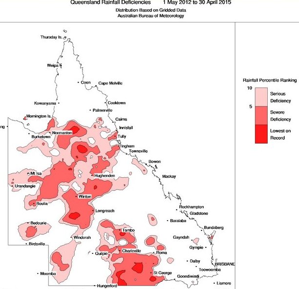
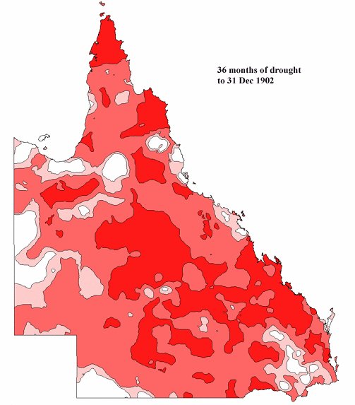
Last night I saw the Longreach drought forum on ABCNews24 at 7.30pm – it will appear again I am sure – nobody spoke the rain history truth. I think the contrast in these two maps shows what a bunch of whiners is encouraged by ABC style misinformation.
First the 3 years to April 30 2015
Now the 3 years to 31 Dec 1902
Just as well our pioneers do not have to hear the ABC rubbish.
Further to my blog re Longreach, I have been checking the drought maps you’ve displayed above. It would appear that the Longreach area is in the ’36 month lowest on record’ shading.
For the 36 months from May, 2012 until Apr 2015, Longreach has recorded just under 800mm.
For the 36 months from May, 1899 until Apr 1902, Longreach had recorded about 630mm.
However the BoM ‘officially’ start its rainfall record from 1900.
From May, 1900 until Apr 1903, Longreach recorded around 710mm – which surely makes it the official driest 36 months on record.
If you check nearby Beaconsfield, the last 36 months have recorded over 900mms and the 1900-1903 recorded less than 700mms.
The only area which may lay claim to its driest 36 months is Evesham Station (71kms from Longreach) but it has data missing for 2014/15. Ambo station also has present data missing but it had an extremely dry 1901/1902 so I would say the last 36 months were not the driest.
All other stations around Longreach have data which does not include the Federation drought period or have closed.
So for the BoM to represent the Longreach area as the ‘driest 36 month on record’ is a misrepresentation, to put it kindly.
As someone who spent some years in the grazing business I never cease to be amazed how politicians and the media don’t require graziers/ croppers who have been caught out by dry periods to explain what steps they took to consult their long term district rainfall history and how they took account of it in managing their property.
I am similarly amazed at today’s ‘drought relief’ & related schemes which seem to be about providing subsidies for those who took too much of a risk in light of past rainfall history – often combined with too little equity and sometimes at the expense of the more prudent.
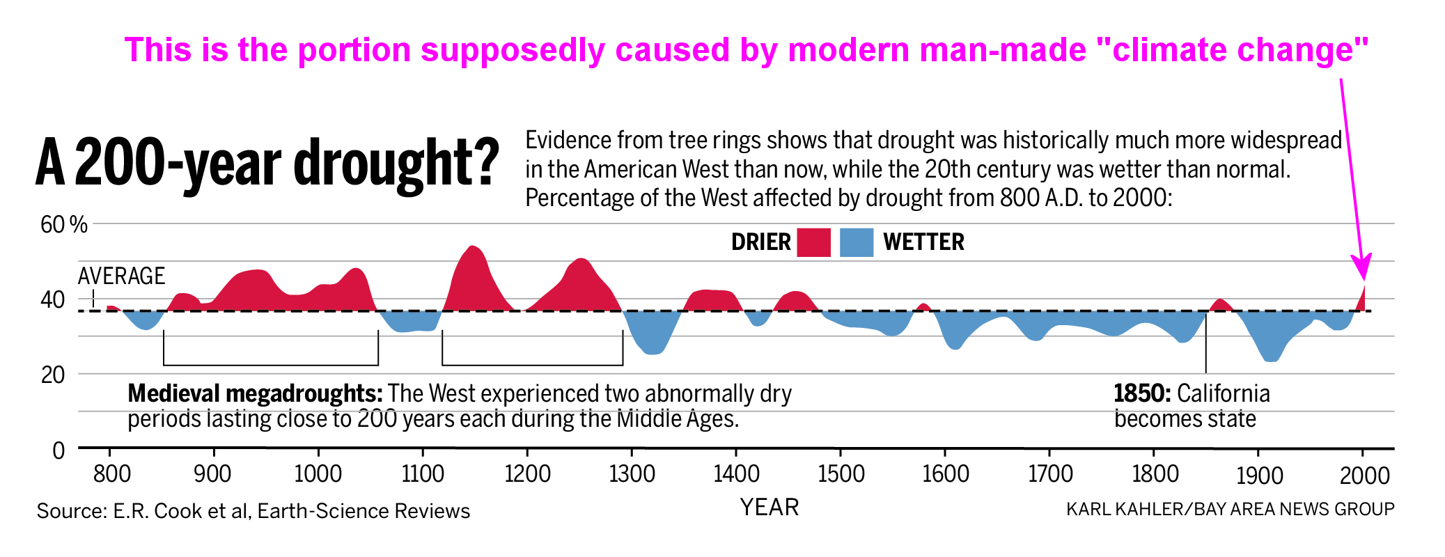
As in the case with climate data, any drought graphic is dependent on the timeframe. If you start at the right point, any climate event can be made to appear “unprecedented.” Most of the California Drought graphs show recent time frames for the past 30, 50, or 100 years. These capture abnormally long wet periods ending in the drought we are in today. If you extend the time frame back to the early 14th Century, there are two 30 year long droughts. If you extend the time frame to begin in the 5th Century, there are two extended periods of drought, each of which is 200 years.
The following graphic was posted in the San Jose Mercury News.
Brooks,
I can see a ‘problem’ with the drought maps in the start time for each map. Is the 1902 drought map based on data prior to 1902 or does it incorporate all the data to the present? (If it did, the map itself may need to change each year depending on the new data).
I needed to go back to the Fed drought rainfall data and compare it with the present drought situation to see if the maps reflected reality. In this case, it appears that the Fed drought was worse than the present one.
PS Interested in your San Jose graphic – doesn’t appear to be posted.
Thanks for the comment. I sent Warwick the graphic. The story is www.mercurynews.com/science/ci_24993601/california-drought-past-dry-periods-have-lasted-more
Thanks.
Here is the graphic from the San Jose Mercury News
Worth a separate article I think.
Thanks, Wazsah!
The rainfall presentations I like are those available from the Qld government longpaddock website
www.longpaddock.qld.gov.au/products/australiasvariableclimate/index.html
Agree that LongPaddock pdf page of many rain anomaly maps provides a great synoptic view of over a century of Australian rain and drought. Pity more people who buy farm properties are not aware of the data and the rain history of their districts.
In other business ventures it’s called ‘due diligence’.