Jones et al 1986 looked at 86 Australian stations and rejected 46 (25 Short term – 21 long term). Of the 40 they used 27 were short term and 13 long term. Of the long term there were 5 large cities.
The 27 short term stations were mostly only quoted from 1951 onward – regardless of what data was available. It just so happens that the years just post WWII were not prominently warm in Australia so an “automatic” warming trend was reinforced into the CRU Australian component.
Here are 11 examples where Jones et al systematically truncated pre-1951 data or ignored more rural data around many small town Australian stations. These graphics and text have been extracted from a 1992 vintage Word doc that somehow survived the decades and how many HDD’s. Note 27 Nov 09 to clear up any ambiguity – check my comment (WSH) 17 below.
Port Hedland
The aerodrome records 1951-80 shows a clear warming trend. Marble Bar, 150 kms south east, shows a similar trend over that period but a flat trend over 80 odd years.

Longreach
For the period 1951-80 this trend is sharply upward, yet if the Longreach Post Office record is spliced to the aerodrome record (post 1940s) the trend becomes markedly flatter. When Longreach is compared to Isisford, a much smaller rural centre 80 kms south, the trend is closer to neutral over about 70 years.

Mackay
The A.M.O. record 1951-80 shows a clearly steeper warming trend for Mackay when compared with St Lawrence and Pine Islet Lighthouse.

Rockhampton
Compared to Bustard Head Lighthouse and St. Lawrence, Rockhampton shows a warming trend of about 0.5°C over 70 years. Rockhampton data was used only for the period 1951-1970. The two nearby more rural sites show a similar temperature pattern but a negligible temperature change over 70 years.

Meekathara
The Aerodrome record 1951-80 shows a clear strong warming trend. The small centre of Cue, 120 kms south west however has a flat trend over 90 years.

Charleville
The trend for this station 1951-80 also shows a strong warming trend. Cunnamulla, a smaller centre approximately 170 kms south, shows a much flatter trend over about 80 years.

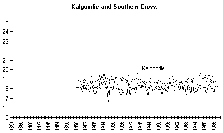
Kalgoorlie
The aerodrome record 1941-80 shows a well defined warming. However, when Post Office records are spliced on, the trend is much closer to zero over 90 years. Looking at Southern Cross, a continuous Post Office record, approximately 200 kms west, the trend is very similar, flat over some 90 years.

www.warwickhughes.com/cru86/tr027/kalgoorlie.gif
Forrest
This station 1951-80, shows a steeper warming trend than the nearby Rawlinna, where records go back to 1926.

Ceduna
A warming trend is seen over the 1951-80 period, yet the longer term and more remote Streaky Bay, where records are available back to 1925, shows a flatter trend.

Woomera
Once again, this record shows the 1951-80 warming. Broken Hill, the nearest long term station in a similar climate, shows a cooling trend over a hundred year time span.

Mt. Gambier
From 1951-80 this aerodrome station shows a strong warming trend. When the Post Office records are spliced on the trend 1860s to 1990, it is close to neutral.

Using the 30 year statistics for places like Gunnedah, Bourke, Broken Hill, Casino, Murrurundi and Yamba, which all have long-term records, they all show falls in temperature from the late 1800s and the first half of the 1900s. One, of course, will have to wait for the 1981-2010 averages to be calculated but I’m sure they will not beat those old records. Are any of those included in the final 40 weather stations?
By the way, has anyone seen the NSW drought map. The only satisfactory area is the central tablelands. This would come as a shock to the people of the mid-north coast around Coffs Harbour who have had some 2400mm+ so far this year (it’s described as marginal – they had over 500mm for this month so far).
Weatherzone had a story this week about a November heatwave in Gunnedah in 1878 -15 days of over 35C. I wonder how much of that area was also affected?
I have also done my own plots for Geelong and Cape Otway (1902-2008). Cape Otway shows an increase (linear trend) of only 0.3 degrees in 107 years, and Geelong (urban but adjacent to Corio Bay till 1996) a perfectly flat trend. The move to Geelong Airport (semi-rural) from 1996 caused a temporary fractional increase but not near any previous extremes. Geelong’s hottest years are (in order) 1988, 1928 and 1959. Cape Otway’s highest were in 2007, then 1998 and 1921. If I had enough IT knowledge I could include the graphs.
Ian, you ask, “Are any of those included in the final 40 weather stations?”
The situation for Jones 1986 Sth Hem compilation – is that Sydney and Melbourne aside, there is not one station, long or short term, between Brisbane and Mt. Gambier. This area includes all of NSW and Victoria and contains the greatest concentration of long term recording stations in Australia. Must be one of the great and complete exclusions in the history of science.
See my Graph 1 and Graph 2 about two thirds way down this page.
Sorry to be a pest but…..
In the light of the New Zealand ‘fudge of temperature figures’ just hitting cyberspace, may I revisit the post I made earlier regarding the October max av temps data in NSW. As I have pointed out before, when I add all 185 temps for NSW and divide them, I do not get their figure of 25.2°C which is 0.7°C above the historical average of 24.4°C but a figure below 25.2C. I assume that this is the way the average is calculated but stand corrected if I am wrong.
The summary statistics are at:
www.bom.gov.au/climate/current/month/nsw/summary.shtml
Does anyone know?
Just found this
www.bom.gov.au/cgi-bin/climate/hqsites/site_data.cgi?variable=maxT&area=wa&station=004020&dtype=raw&period=annual&ave_yr=0
doesn’t look anything like this
www.bom.gov.au/jsp/ncc/cdio/weatherData/av?p_display_type=dataGraph&p_stn_num=004020&p_nccObsCode=36&p_month=13
Interesting.
Warwick You might like to look at WUWT re this post
wattsupwiththat.com/2009/11/25/uh-oh-raw-data-in-new-zealand-tells-a-different-story-than-the-official-one/
I left a msg on that posting re the wealth of NZ data you have and kindly sent to me a while back. If you are so inclined it might be worth putting up a couple of graphs on WUWT of some of the long term remote sites that you have data for. eg Hamner, Coleridge, etc.
Just a thought. Kind regards
Ian; I think the BoM NSW average they quote for Oct would derive from their gridded product. I have never been able to discover which stations contribute to their gridded data.
Ripper; At your first URL, where the BoM say “High Quality” – that translates to “tweaked and stroked”. Good on you for picking that example up.
Terry; Thanks for dropping by, great that the Salinger/NIWA warming tweaks are now being exposed for what they are.
Remember this “Hadley Centre inserts more warming into New Zealand climate history”
A few years ago I posted graphics for raw NZ station data for both islands – that I worked on in 1994.
North Island
South Island
Obviously there are some inhomogeneities in the raw data – but nothing to warrant the Salinger / NIWA treatment.
Theres more,
Southern cross , Kalgoorlie , Geraldton have all just copped the “treatment”
Your taxes at work.
What you discovered in Australia occurred world wide. After 1950, GISS added ~3,000 stations to its Surface Temperature Analysis, thereby overstating the subsequent temperature increase. Considering only those stations (422 plus the US) with periods of record starting before 1940 (the mid-century high and also the start of CO2 increases), the net global temperature increase by my calculation was only 0.2 deg C – statistically insignificant.
Sam (in CA) Says:
November 26th, 2009 at 9:57 am
What you discovered in Australia occurred world wide. After 1950, GISS added ~3,000 stations to its Surface Temperature Analysis, thereby overstating the subsequent temperature increase.
I am so happy that this data “fudging” includes NSAS-GISS. The entire shows at CRU and GISS need to be cleaned up. These people have been using advocacy psuedo-science and hiding behind their cabal which peer review each other.
Hi Warwick
I tend to write about historic examples of climate change- which the scientific establishment seem to want to ignore or minimise.
Recently I have taken an interest in the obvious climatic variability as recorded by instruments prior to 1850-Hadley/cru and 1880 Giss. This neatly picks up the fact that both measured from the bottom of LIA dips and subsequent recovery consequently looks MUCH more impressive than if you step back and look at what happened BEFORE the start of their data.
Article: reliability of temperature records (leads to my new web site containing some 60 records back to 1660)
wattsupwiththat.com/2009/11/14/little-ice-age-thermometers-%e2%80%93-history-and-reliability/
Three linked temperature records
noconsensus.wordpress.com/2009/11/25/triplets-on-the-hudson-river/#comment-13064
Article: Historic instrument readings demonstrate climatic variability
noconsensus.wordpress.com/2009/11/05/invisible-elephants/
Hope this resource might be of interest to you or your readers
Tonyb
Maybe there’s more background that I missed somewhere, but this is a bit hard to follow. Was the word doc among the CRU files? Or is it a coincidence that this is coming out at the same time or did you produce this earlier and just are re-releasing it now? Is the text between the graphs yours or that was in the word doc? Whose word doc was it?
TonyB; Thanks for those links, I think the BoM paper your quote re introduction of Stevenson screen is on balance wrong and was just written to reinforce their mythology.
I had a paper in the same journal earlier in 1995 quoting chapter and verse from historical records how the SS or close copy was in common use in Australia, Fiji, NZ, in the late 1800’s. There is even a photo from 1890 of an SS in the Darwin Post Office. Darwin !! Do you seriously think the SS was not used then in the more civilised parts of the colonies ?
Reading your third link I see discussion of the red graph of Torok, UHI in Australian country towns. I agree with the shape of that curve because it we found something very similar in a mid 1990’s paper “Eastern Australia temperature variations 1930-1992” where we went to a lot of trouble to uncover data from very rural sites. The paper is scanned.
Our graphic suggesting the exponential curve is the last scanned page;
Thanks TonyB.
Sean; Yes there is a lot of background you have missed Sean. If you scroll down two thirds of this page where I started a 20th anniversary review of Jones et al 1986, you see a section headed, “[2] Tasman Institute 1991 review of the Australian component of temperature records used in the 1986 Jones et al Southern Hemisphere paper,”
That is the Executive Summary of a 20 odd page paper I wrote in 1991 critical of the Jones et al 1986 Australian component of their southern hemisphere compilation. The two refs for which are given at the above link.
So my blog entry that you commented on – text and graphics – are from this word doc of mine, from 1991-92 – which has never seen the light of day since the early 1990’s. It was circulated to the BoM who attacked it while grudgingly agreeing with the main findings. Also circulated to Tasman Institute sponsors who no doubt had the BoM in their ear, the upshot was it never went any further but I have been researching temperature data on and off ever since. In answer to your questions to make it crystal clear;
Was the word doc among the CRU files? No
Or is it a coincidence that this is coming out at the same time, My choice of timing.
or did you produce this earlier Yes in 1991-92
and just are re-releasing it now? Yes
Is the text between the graphs yours or that was in the word doc? Mine from 1991-92
Whose word doc was it? Mine and Tasman Institute – I certainly got much help from TI staffers bashing my rough research into some sort of shape. I am sure a more skilled researcher could have done a better job than me.
The real scandal Sean is that the BoM knew of this blatantly poor science by Jones et al and remained silent. The birth of global warming was assisted by a lot of silence, the only journal comment was by Wood in 1988. I have his paper and the Wigley & Jones reply all scanned with comments here.
In March this year I started jotting down an account of my contacts with the BoM from 1991.
“Some early contact with bias and mythology in the Australian Bureau of Meteorology BoM near two decades ago”
Thank you Sean.
Thanks for replying to my blog above. Still, looking at the summary statistics doesn’t seem to suggest a positive 0.7C anomaly. It would be nice to see which NSW stations they use to calculate that figure.
Here’s a little bit of trivia which may demonstrate the UH effect. Casino has 2 weather stations, a manual (058063) and an automatic (058208), within 300m of each other (lat and long positions are the same). The manual w/s is only metres from a tarred road and surrounded by buildings on all sides. The AWS is in the middle of a grassed oval with no road or buildings within 50-60m and with about 300 degree open exposure to the elements.
The manual always reads higher maximum temps than the AWS, usually 0.6C to 0.9C. Surprisingly, minimum temps are a bit closer, but the manual will usually read higher. And all this within a distance of 300m.
The 300 metres difference can replicated at 30 metres
If the ground is wet the difference is virtually Zero
Warwick #17
Thanks for your comments. I take this comment from your linked paper ‘similar local variant’
I agree. I think virtually every advanced country had some sort of effective screen far earlier than the SS. The reason for using that example is purely to point out the official thinking is muddled-if only SS stations should be used as a ‘reliable’ modern record that date should be from the first decade or so of the 20th century when the majority of places had such a branded device-not from 1880 or 1850.
My contention-(in my second article examining the much older records) is that the need for screening was very well understood in the 18/19th Century with readings often carried out by very skilled observers. I would maintain the old records (pre 1880) are as reliable as post 1880 ones-probably more so as they weren’t modified or subject to uhi or other siting problems.
However, bearing in mind the natural drawbacks of a none digital thermometer I don’t think we can do more than accept the generality of their measurement-I don’t believe they were accurate to small fractions of a degree, nor that sticking together the readings from hundreds of local thermometers can create an accurate global temperature
Tonyb
One thing Ive always been interested in is the spike in temps at Observatory hill especially on very cold days. The BOM records of temps seems to jump up markedly (often 1 – 2 degrees) whilst the rest of Sydney seems flat. Often this jump means cold records arnt broken.
twawki; how about sending some numbers to illustrate this. Are you seeing this in the 30min data as seen at these pages ?
You can check the truth/falsity of global warming yourself here in
Australia by accessing the Bureau of Meteorology’s archives. Here is a
very simple exercise you can do yourself to judge the truth (or otherwise)
about global warming (I think the data for Cape Otway and Wilsons Prom are enormously instructive):
Goto: Weather Station Data:
www.bom.gov.au/climate/data/weather-data.shtml Look for ‘Long
Record Temperature Stations’, (they are below, right)Open (in Microsoft
Excel), Click top left box between 1 & A which will highlight all boxes,
Choose: Data, Sort, Column F, OK which will sort them from oldest to
newest. Note some have closed, so chose ones with the most complete
datasets. Also chose ones which are most remote or which you know or
figure have been subject to the least change over time eg population
growth, land clearing etc. Then go and find them here:
Goto: Climate statistics for Australian sites:
www.bom.gov.au/climate/averages/tables/ca_site_file_names.shtml
Choose eg in Monthly Statistics New South Wales, Gunnedah Pool, Monthly
statistics, Click (VERY IMPORTANT) under map All Available, then notice
Highest Temperature, LowestMaximum Temperature, Lowest Temperature,
Highest Minimum Temperature for each month and also note the date in
Column ‘Annual’ when the record occurred. You will notice for Gunnedah
that even though the 19th century comprises only 24 out of 132 years of
data that (counting 1900) it
includes 6 out of 12 of the hottest days and 8 out of 12 of the coldest
days! You will also notice that the period 1975 to 2009 when we have been
told the world has been warming most and when extremes of weather have
been increasing most that NONE of the hottest days have been in that
period but 3 of the coldest have been! Since that period comprises 32 out
of 132 of the years of data you should expect a like proportion to that of
extreme days of all sorts or 24.24% or about one in four (3 out of 12)as
we find with the coldest days. But as NONE of the hottest days occurs in
that period (though we should expect one quarter of them to – again 3 out
of 12) we can only conclude that Gunnedah at least has cooled in the last
32 years! If you look at the four Annual climate extremes for Gunnedah you
will see 24 Jan 1882 (hottest), 4 Aug 1921 (lowest maximum), 27 June 1881
(coldest), 2 Jan 1905 (warmest night). In other words far from extreme
weather events increasing recently it has been 87 years since Gunnedah
experienced an extreme weather event!
Perhaps the REST of Australia (or the world) has warmed and Gunnedah is
the exception? I have looked at a selection of the more remote sites on
the Australian Weather Bureau’s site which have long-term records (eg Cape
Otway Vic ) and found the same pattern, ie very few of the hottest days
have occurred in the period 1975-2008 and a very high proportion of the
hottest days occurred in the 19th century. You have to choose sites which
have long-term records comprising the last quarter of the nineteenth
century up to 2009 otherwise some relatively warm years recently will
appear to be the warmest when they were not. Obviously large cities WILL
have warmed because of the urban heat island effect NOT because the
climate has changed.
You have to be VERY careful to notice what years have been averaged in
the column ‘Years’ as even though the station may have data from eg 1869
to 2008, it may be that the data averaged is only 1970-2008 or the like.
Some sites have moved too and so or not very reliable eg Melbourne
Regional Office has averages from 1855-2008 but the site only BEGAN in
1908 which begs the question of where the earlier data comes from and is
it comparable? Even so, for that site (a very warm site because of the
huge growth of the city) only two out of 12 of the hottest days were in
that period and they were both back in the 1980’s. The three hottest days
by a long shot were in 1938-1940. (Black Saturday may have eclipsed this –
but this day cannot have been the hottest in Victoria’s history because of
the urban heat island effect; indeed because of that it must have been a
number of degrees cooler than Black Friday in 1939). Sydney Observatory
has 6 out of 12 of
the hottest days in the defined period but no-one would have thought
Sydney had not warmed.
Deniliqiuin is one of the oldest continuous sites: It has 2 out of 12
hottest
days; Bourke has 1 out of 12; Boulia has 0 out of 12; Marble Bar has 3/12
etc.
You can look at the actual temperature records for each site by going to:
www.bom.gov.au/climate/data/weather-data.shtml
And typing in the station number you found on the Excel page above. Be
sure to sort for temperature. Go to the page and then be sure to
Highlight: Highest to see when the warmest months occurred.
You can look at the NASA/GISS records for the ‘same’ sites by going to:
data.giss.nasa.gov/gistemp/station_data/ typing in the Station Name
at #2, hit return, be sure you have the right one by latitude and
longitude (You can check it against the Bureau of Meterology’s record).
Then compare.
APPENDIX 2
Here are the only fifteen (sixteen counting Bathurst) sites (from the sort
you did earlier – I have since found a few more from the List of All
Stations on the same page – whose records begin in the 19th century and
extend into the 21st century. I have included the Bureau of Meterology’s
Temperature Records and Climate Statistics for them and for comparison
Nasa/Giss’s Record. The sites are ordered by date of opening.
There are a number of other sites which have records going back well into
the 19th Century but which closed usually over thirty years ago so that
the temperature in the 19th Century cannot directly be compared with the
temperature in say the last thirty years. One would have to compare the
records from a site nearby. These sites are: Bourke NSW 1871 (GISS
1880-1992), Wagga Wagga NSW 1871 (GISS 1942-2009), Forbes NSW 1873 (GISS
1880-1992), Inverell NSW 1874 (GISS 1907-1992), Alice Springs Post Office
NT 1878 (GISS 1880-2009), Walgett Council Depot NSW 1878 (GISS 1880-1992),
Cobar NSW 1881 (GISS 1962-2009), Darwin Post Office NT 1885 (GISS
1882-2009)…
In EVERY case you can see that what NASA/GISS has done is to exclude data
from the period 1850-1882 even if a available. This is
‘unfortunate’
as
in
every case (in rural areas) this period appears to have been the hottest
on record by a long shot. If you graph the average temperatures by month
over the full period 1850-2009 you will see that in practically every case
there has been a decline of approximately 2 degrees Celsius over this
period – which contrasts very sharply with the global warmers’ claims of
an increase in temperature of approximately 1 degree Celsius over this
time.
I include a Microsoft Excel pivot chart plot of Cape Otway (data taken
from the Bureau of Meterology’s website here
www.bom.gov.au/jsp/ncc/cdio/weatherData/av?p_nccObsCode=36&p_display_type=dataFile&p_startYear=&p_stn_num=090015
) to illustrate this. You can very clearly see the temperature drop for
every month (1864-2009) over this time. You will also notice that there is
nothing very interesting about the last thirty years which is the period
that all the fuss is about. A more pertinent question might be: ‘Why did
temperature fall by approx 2 degrees Celsius about the end of the 19th
century and remain relatively static since?’
You can produce your own chart of each site by following these
instructions:
Here are the sites:
Melbourne Regional Office Temperature Record 1855-2009: Click: Highlight
data in table: Highest:
www.bom.gov.au/jsp/ncc/cdio/weatherData/av?p_nccObsCode=36&p_display_type=dataFile&p_startYear=&p_stn_num=86071
Melbourne Regional Office Climate Statistics 1855-2009:
www.bom.gov.au/climate/averages/tables/cw_086071_All.shtml
Melbourne Regional Office Nasa/Giss record 1880 – 1992: Click: monthly
data as text:
data.giss.nasa.gov/cgi-bin/gistemp/gistemp_station.py?id=501948680000&data_set=1&num_neighbors=1
Bathurst Gaol Climate Statistics 1858-1903:
www.bom.gov.au/climate/averages/tables/cw_063004_All.shtml
Bathurst Gaol Temperature Record 1858-1903: Click: Highlight data in
table: Highest:
www.bom.gov.au/jsp/ncc/cdio/weatherData/av?p_nccObsCode=36&p_display_type=dataFile&p_startYear=&p_stn_num=063004
Bathurst Agricultural Station Climate Statistics 1908-2009:
www.bom.gov.au/climate/averages/tables/cw_063005_All.shtml
Bathurst Agricultural Station Temperature Record 1908-2009: Click:
Highlight data in table: Highest:
www.bom.gov.au/jsp/ncc/cdio/weatherData/av?p_nccObsCode=36&p_display_type=dataFile&p_startYear=2009&p_stn_num=063005
Bathurst Agricultural Nasa/Giss record 1909 – 1992: Click: monthly data as
text:
data.giss.nasa.gov/cgi-bin/gistemp/gistemp_station.py?id=501947300000&data_set=1&num_neighbors=1
Deniliquin NSW (Wilkinson St) Temperature Record 1858-2003: Click:
Highlight data in table: Highest:
www.bom.gov.au/jsp/ncc/cdio/weatherData/av?p_nccObsCode=36&p_display_type=dataFile&p_startYear=&p_stn_num=74128
Deniliquin NSW (Wilkinson St) Climate Statistics 1858-2003:
www.bom.gov.au/climate/averages/tables/cw_074128_All.shtml
Deniliquin NSW (Wilkinson St) Nasa/Giss record 1880 – 1992: Click: monthly
data as text:
data.giss.nasa.gov/cgi-bin/gistemp/gistemp_station.py?id=501948690000&data_set=1&num_neighbors=1
Sydney (Observatory Hill) Temperature Record1859-2009: Click: Highlight
data in table: Highest:
www.bom.gov.au/jsp/ncc/cdio/weatherData/av?p_nccObsCode=36&p_display_type=dataFile&p_startYear=&p_stn_num=66062
Sydney (Observatory Hill) Climate Statistics 1859-2009:
www.bom.gov.au/climate/averages/tables/cw_066062_All.shtml
Sydney (Observatory Hill) Nasa/Giss record 1880 – 1992: Click: monthly
data as text:
data.giss.nasa.gov/cgi-bin/gistemp/gistemp_station.py?id=501947680000&data_set=1&num_neighbors=1
Cape Otway (Vic) Temperature Record 1864-2009: Click: Highlight data in
table: Highest:
www.bom.gov.au/jsp/ncc/cdio/weatherData/av?p_nccObsCode=36&p_display_type=dataFile&p_startYear=&p_stn_num=090015
Cape Otway (Vic) Climate Statistics 1864-2009:
www.bom.gov.au/climate/averages/tables/cw_090015_All.shtml
Cape Otway (Vic) Nasa/Giss record 1901 – 2009: Click: monthly data as text:
data.giss.nasa.gov/cgi-bin/gistemp/gistemp_station.py?id=501948420000&data_set=1&num_neighbors=1
Gunnedah Pool NSW Temperature Record 1876-2009: Click: Highlight data in
table: Highest:
www.bom.gov.au/jsp/ncc/cdio/weatherData/av?p_nccObsCode=36&p_display_type=dataFile&p_startYear=&p_stn_num=055023
Gunnedah NSW Pool Climate Statistics 1876-2009:
www.bom.gov.au/climate/averages/tables/cw_055023_All.shtml
Gunnedah NSW Resource Centre Temperature Record: Click 1948-2009:
Highlight data in table: Highest:
www.bom.gov.au/jsp/ncc/cdio/weatherData/av?p_nccObsCode=36&p_display_type=dataFile&p_startYear=&p_stn_num=055024
Gunnedah NSW Resource Centre Climate Statistics 1948-2009:
www.bom.gov.au/climate/averages/tables/cw_055024_All.shtml
Gunnedah Composite NSW Nasa/Giss record 1907 – 1992: Click: monthly data
as text:
data.giss.nasa.gov/cgi-bin/gistemp/gistemp_station.py?id=501947420010&data_set=1&num_neighbors=1
Hobart (Ellerslie Rd) Temperature Record 1882-2009: Click: Highlight data
in table: Highest:
www.bom.gov.au/jsp/ncc/cdio/weatherData/av?p_nccObsCode=36&p_display_type=dataFile&p_startYear=&p_stn_num=94029
Hobart (Ellerslie Rd) Climate Statistics 1882-2009:
www.bom.gov.au/climate/averages/tables/cw_094029_All.shtml
Hobart Regional Office Nasa/Giss record 1882 – 1992: Click: monthly data
as text:
data.giss.nasa.gov/cgi-bin/gistemp/gistemp_station.py?id=501949700010&data_set=1&num_neighbors=1
Robe Comparison (SA) Temperature Record 1884-2009:: Click: Highlight data
in table: Highest:
www.bom.gov.au/jsp/ncc/cdio/weatherData/av?p_nccObsCode=36&p_display_type=dataFile&p_startYear=&p_stn_num=26026
Robe Comparison (SA) Climate Statistics 1884-2009:
www.bom.gov.au/climate/averages/tables/cw_026026_All.shtml
Robe Comparison (SA) Nasa/Giss record 1957 – 2009: Click: monthly data as
text:
data.giss.nasa.gov/cgi-bin/gistemp/gistemp_station.py?id=501948120000&data_set=1&num_neighbors=1
Boulia (Qld) Temperature Record 1888-2009: Click: Highlight data in table:
Highest:
www.bom.gov.au/jsp/ncc/cdio/weatherData/av?p_nccObsCode=36&p_display_type=dataFile&p_startYear=&p_stn_num=038003
Boulia (Qld) Climate Statistics 1888-2009:
www.bom.gov.au/climate/averages/tables/cw_038003_All.shtml
Boulia (Qld) Nasa/Giss record 1900 – 1992: Click: monthly data as text:
data.giss.nasa.gov/cgi-bin/gistemp/gistemp_station.py?id=501943330000&data_set=1&num_neighbors=1
Burketown (Qld) Post Office Temperature Record 1890-2009: Click: Highlight
data in table: Highest:
www.bom.gov.au/jsp/ncc/cdio/weatherData/av?p_nccObsCode=36&p_display_type=dataFile&p_startYear=&p_stn_num=29004
Burketown (Qld) Post Office Climate Statistics 1890-2009:
www.bom.gov.au/climate/averages/tables/cw_029004_All.shtml
Burketown (Qld) Post Office Nasa/Giss record 1907 – 2009: Click: monthly
data as text:
data.giss.nasa.gov/cgi-bin/gistemp/gistemp_station.py?id=501942590000&data_set=1&num_neighbors=1
Port Lincoln (SA) Temperature Record 1892-2002: Click: Highlight data in
table: Highest:
www.bom.gov.au/jsp/ncc/cdio/weatherData/av?p_nccObsCode=36&p_display_type=dataFile&p_startYear=&p_stn_num=18070
Port Lincoln (SA) Climate Statistics 1892-2002:
www.bom.gov.au/climate/averages/tables/cw_018070_All.shtml
Port Lincoln (SA) Nasa/Giss record 1922 – 1992: Click: monthly data as
text:
data.giss.nasa.gov/cgi-bin/gistemp/gistemp_station.py?id=501946600000&data_set=1&num_neighbors=1
Gayndah (Qld) Post Office Temperature Record 1893-2009: Click: Highlight
data in table: Highest:
www.bom.gov.au/jsp/ncc/cdio/weatherData/av?p_nccObsCode=36&p_display_type=dataFile&p_startYear=&p_stn_num=39039
Gayndah (Qld) Post Office Climate Statistics 1893-2009:
www.bom.gov.au/climate/averages/tables/cw_039039_All.shtml
Gayndah (Qld) Post Office Nasa/Giss record 1894 – 1992: Click: monthly
data as text:
data.giss.nasa.gov/cgi-bin/gistemp/gistemp_station.py?id=501945430000&data_set=1&num_neighbors=1
Richmond (Qld) Post Office Temperature Record 1893-2009: Click: Highlight
data in table: Highest:
www.bom.gov.au/jsp/ncc/cdio/weatherData/av?p_nccObsCode=36&p_display_type=dataFile&p_startYear=&p_stn_num=30045
Richmond (Qld) Post Office Climate Statistics 1893-2009:
www.bom.gov.au/cli:mate/averages/tables/cw_030045_All.shtml
Richmond (Qld) Post Office Nasa/Giss record 1908 – 2009: Click: monthly
data as text
data.giss.nasa.gov/cgi-bin/gistemp/gistemp_station.py?id=501943400000&data_set=1&num_neighbors=1
Georgetown (Qld) Post Office Temperature Records 1894-2007: Click:
Highlight data in table: Highest:
www.bom.gov.au/jsp/ncc/cdio/weatherData/av?p_nccObsCode=36&p_display_type=dataFile&p_startYear=&p_stn_num=30018
Georgetown (Qld) Post Office Climate Statistics 1894-2007:
www.bom.gov.au/climate/averages/tables/cw_030018_All.shtml
Georgetown (Qld) Post Office Nasa/Giss record 1907 – 1992: Click: monthly
data as text
data.giss.nasa.gov/cgi-bin/gistemp/gistemp_station.py?id=501942750000&data_set=1&num_neighbors=1
Low head (Comparison) Tas Temperature Records 1895-2001: Click: Highlight
data in table: Highest:
www.bom.gov.au/jsp/ncc/cdio/weatherData/av?p_nccObsCode=36&p_display_type=dataFile&p_startYear=&p_stn_num=91057
Low head (Comparison) Tas Climate Statistics 1895-2001:
www.bom.gov.au/climate/averages/tables/cw_091057_All.shtml
Low head (Comparison) Tas Nasa/Giss record 1895 – 1992: Click: monthly
data as text
data.giss.nasa.gov/cgi-bin/gistemp/gistemp_station.py?id=501949650000&data_set=1&num_neighbors=1
Nhill (Vic) Temperature Records: Click: Highlight data in table: Highest
1897-2008:
www.bom.gov.au/jsp/ncc/cdio/weatherData/av?p_nccObsCode=36&p_display_type=dataFile&p_startYear=&p_stn_num=78031
Nhill (Vic) Climate Statistics 1897-2008:
www.bom.gov.au/climate/averages/tables/cw_078031_All.shtml
Nhill (Composite) (Vic) Nasa/Giss record 1897 – 1992: Click: monthly data
as text:
data.giss.nasa.gov/cgi-bin/gistemp/gistemp_station.py?id=501948270000&data_set=1&num_neighbors=1
Some other long-terms sites not found on the Bureau’s Long Term
Temperature Stations List (I don’t know why not, ask them):
Omeo Comparison Temperature record Click: Highlight data in table: Highest
(1879-1909):
www.bom.gov.au/jsp/ncc/cdio/weatherData/av?p_nccObsCode=36&p_display_type=dataFile&p_startYear=&p_stn_num=083025
Wilsons Promontory Lighthouse Click: Highlight data in table: Highest
(1877-2009):
www.bom.gov.au/jsp/ncc/cdio/weatherData/av?p_nccObsCode=36&p_display_type=dataFile&p_startYear=&p_stn_num=085096
Here is a sample of other Long Term (or very old) Stations which have
their data unavailable or foreshortened, eg:
Wangaratta Station (1868-1987) No 082053 – first approx 40 years
temperature of data missing.
Wahgunya (1868-1979) Station No 082051 – all temperature data missing.
Aberfeldy (1891-1985) Station No 85000 – first 80 years of data missing.
Maffra Shire Hall (1878-1968) Station No 85054 – all temperature data
missing.
Port Albert (1856-1976) Station No 85070 – all temperature data missing.
Rosedale (1878-2007) Station No 85071 – all temperature data missing.
Stratford (1877-1953) Station No 85078 – 55 years of data missing.
Warragul (Carbethon) (1878-1962 Station No 85092 – all temperature data
missing.
Alberton (The Meadows) (1879-1909) Station No 85245 – all temperature data
missing.
Beenak (1878-1952) Station No 86005 – all temperature data missing.
Cape Schank Lighthouse (1879-1997) Station No 86017 – first 3 years of
data missing.
Cowes (1882-1978) Station No 86025 – 55 years of data missing.
Dromana ( 1880-1964) Station No 86032 – all temperature data missing.
Gembrook 1877-1967) Station No 86045 – all temperature data missing.
Hastings Post Office (1872-1969) Station No 86048 – all temperature data
missing.
Warburton (1878-2008) Station No 86121 – all temperature data missing.
Bacchus Marsh (1880-1962) Station No 87002 – 28 years of data missing.
Geelong SEC (1870-1970) Station No 87025 – first 30 years of data missing.
Romsey (1877-1970) Station No 87057 – all temperature data missing.
Barkers Creek Reservoir (1872-1882) Station No 88004 – all temperature
data missing.
Bendigo Channel (1877-1969) Station No 88005 – all temperature data
missing.
Smeaton Weir (1877-1972) Station No 88016 – all temperature data missing.
Expedition Pass Reservoir (1872-1957) Station No 88024 – all temperature
data missing.
Kingston (1871-1954) Station No 88035 – all temperature data missing.
Kyneton Post Office (1873-1969) Station No 88035 – first 14 years of data
missing.
Maldon (Derby Hill) (1878-2008) Station No 88041 – first 30 years of data
missing.
Newlyn Reservoir (1877-1938) Station No 88101 – all temperature data
missing.
Ararat Post Office (1861-1969) Station No 89000 – first 40 years of data
missing.
Glenthompson (1878-1978) Station No 89013 – all temperature data missing.
Ballarat Survey Office (1840-1890) Station No 89049 – all temperature data
missing.
Hamilton (1869-1983) Station No 90044 – first 17 years of data missing.
Mortlake (1879-1996) Station No 90058 – all temperature data missing.
Warrnambool Shire Office (1867-1998) Station No 90081 – all temperature
data missing.
I have had a bit of a look around some of the other states and the same
pattern is repeated, for example, get this:
Port Arthur (1837-1980) Station No 94052 – all temperature data missing.
Campbelltown NSW (1845-1961) Station No 068014 – all temperature data
missing.
You can get the list of all stations from the page:
www.bom.gov.au/climate/data/weather-data.shtml and check them out
yourself. The Bureau has been extraordinarily wanton in junking the
scientific data it has collected over nearly two centuries.
Love your work, Steve
I noticed at the Casino airport station, the ‘all available’ records only go from 1965 yet the temp data goes back to 1908. Therefore, many records set back then do not feature in the ‘all available’ so are more easily broken.
www.bom.gov.au/climate/averages/tables/cw_058063_All.shtml
www.bom.gov.au/jsp/ncc/cdio/weatherData/av?p_nccObsCode=36&p_display_type=dataFile&p_startYear=&p_stn_num=058063
I just noticed that Meekatharra goes back to 1910 when the old PO data was only available from 1926.
reg.bom.gov.au/cgi-bin/silo/reg/cli_chg/timeseries.cgi?variable=rain®ion=aus&season=0112
It appears to have lost 1.5 degrees in the 1930’s as well.
members.westnet.com.au/rippersc/meeka.jpg
Most of the global warming in Australia has been adjusted into the vast unpopulated central Australia.
We want our raw data back.
Check this out,
reg.bom.gov.au/cgi-bin/silo/reg/cli_chg/timeseries.cgi?variable=rain®ion=aus&season=0112
reg.bom.gov.au/cgi-bin/climate/change/timeseries.cgi?graph=rain&area=aus&season=0112&ave_yr=0
Same graph different axiz. The Bom is turning out propaganda.
We need to download and save as many of those old records as possible.
In the light of your research above, plus the new raw data figures for NZ scandal, I have revisited some work I started a couple of years ago and abandoned due to lack of reliable data.
After checking Aust temperatures over the past couple of years, I had noticed that some years (ie 1914) appeared very warm for individual locations yet didn’t appear to translate to the ‘Annual mean temperature anomalies for Australia’ graph at www.bom.gov.au/announcements/media_releases/climate/change/20090105.shtml.
So I starting checking a few individual weather stations records (mainly Qld, NSW and some Vic w/s so far) that have long-term records which include the 1900s and are still operating today.
After comparing 1914 yearly max av temps with 2008, I found that 23 out of the the 30 stations I reviewed showed higher temps in the 1914s than 2008. This appears to be at odds with the official graph which shows 1914 as about 0.2C cooler than 2008.
It’s slow work but I will continue to do some more searching. Based on this snapshot though it appears that 1914 may have been warmer than it shows on the graph mentioned above. Has anyone looked at this and crunched the figures for 1914 or other warm years?
Interestingly, Sydney, Melbourne and Hobart don’t follow this trend – only country areas.
This is the reason I love www.warwickhughes.com. Killer psts.
Gday Warwick
Excellent work, and supports what I have found. I’m currently auditing all 100 High Quality sites to compare adjusted with raw data- BOM says should be neutral result, results show otherwise. I’ve also found significant UHI in quite small towns.
Best wishes
Ken
Thanks for noticing Ken – I did that in 1991. I enjoy seeing the results of other people wrestling with these huge issues.