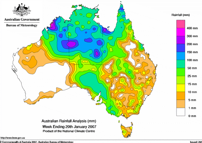
On the 12 Jan the Darwin BoM said (read further below) that the then “monsoon trough” would move north leaving Alice Springs dry. I watched the BoM website radar and satellite images and there was rain on the Monday and the clouds on the satellite image seemed to hang around the general vicinity of the Alice all week, then later in the week it rained so much the usually dry Todd River ran a banker. See map of Australian rainfall for week ended 20 Jan 2007.
Poor old BoM, another trick they could not take.
Last Update: Friday, January 12, 2007. 9:00pm (AEDT) ABC Online
Monsoon trough moving north, says bureau
The Bureau of Meteorology says Central Australia is unlikely to see much more rain from the current monsoon trough.
Parts of the region have recorded falls between 20 and 50 millimetres over the past week.
The bureau’s Graeme King says some of the drought-affected properties south-east of Alice Springs have largely missed out on the rain.
“Most of it would have been focussed up to the north and north-west nearer the monsoon trough for sure, up around Yuendumu,” he said.
“It looks like the monsoon trough might be trying to move slowly up to the north again.
“I’d say there’s still some more rain for the Alice district, but clearing out from the south tomorrow and by the time we get to Sunday and Monday most of the Alice should be fine.”
Meanwhile all one sees in the mainstream media is an unending big dry, from shore to shore, with cattle bones whitening in the baking sun … how dramatic! 😉