Carnegie in central WA is used in ACORN to adjust Giles!!! Replaced original WA map with Australian map and added 3 days of August.

Carnegie in central WA is used in ACORN to adjust Giles!!! Replaced original WA map with Australian map and added 3 days of August.
You once found a night time hotspot. On the NT-WA border. Is there a link to that? BTW; Longpaddock seems to be showing a creeping towards La Nina numbers.
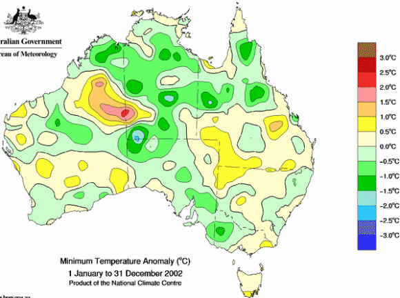
Here is my last animation of annual charts showing the National Night-Time HotSpot – from about 3 years ago. “National Night-time Hotspot” (NNTHS) errors still in BoM temperature anomaly maps 2002-2007 14 Jul 2014 – I first noticed the NNTHS in 2011 (the NNTHS appears nicely again in 2011 too BTW)
Just checked the site summary for there and it seems to show that Australia had GPS satellites in 1942 when this station was first move on the day it was opened. Sometime after that they were able to do “rather different” surveys. From which the number was then changed by zero to the exact same number as before the change.
“01/JAN/1942 STATION longitude Changed to 122.9739Coordinates confirmed by GPS.
22/MAY/2002 STATION longitude Changed to 122.9753GPS using WGS84
30/NOV/2001 STATION longitude Changed to 122.9753previous position supposed to have been by survey but is rather different”
Also a thermometer was installed in September 1988 so that nothing at all could be read from it for three months.
www.bom.gov.au/clim_data/cdio/metadata/pdf/siteinfo/IDCJMD0040.013015.SiteInfo.pdf
That national hot spot appears to cover the whole of Lake Mackay, Australia’s 4th largest lake. Must be all the heat bouncing off the dry salt. Like Lake Eyre it is mostly a dry salt lake with occasional flooding. www.australiangeographic.com.au/blogs/photography/2015/01/the-ephemeral-lake-mackay
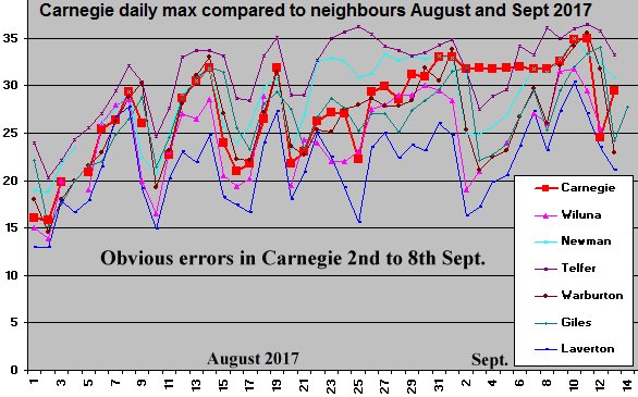
Are you aware these Carnegie maximum errors extend at least a few days into August?
Siliggy, FYI, the first GPS satellite was launched in 1973 and was for exclusive US military use. It wasn’t until a decade later that the GPS was released for commercial use.
Wish we had GPS receivers when we were doing geological surveys and well locations (for oil exploration) in the forests of Borneo during the 70’s and early 80’s. Sadly, those same forests we explored have most probably been illegally logged & burnt down then replaced with the dreaded oil palm plantations.
Lance it is possible that changes in the grid projection used in Australia that generally happened around 2000 might cause small variations in lat & longs as recorded by BoM. I do not know about WA but from memory in NSW the differences are ~113m east west and 184m north south.
Here is a Tassie Govt page that shows the diffs in secs.
dpipwe.tas.gov.au/land-tasmania/geospatial-infrastructure-surveying/geodetic-survey/transformation-of-coordinates
The hot spot is there as “proof” of global warming. Unfortunately the weather balloons were unable to lift it into the troposphere.
Surely Giles is the perfect Met station. No UHI. No TOBS. Why should it need any adjustment whatsoever?
This fault in Carnegie may not last long but my animation will track it to the end. And Carnegie is not an ACORN station see ACORN map 2nd link.
www.bom.gov.au/climate/change/acorn-sat/
Carnegie is in that yawning gap between Giles and Meekathara but amazingly was used to adjust some early mins in Giles – despite Giles being a purpose built manned(oops Woman’d) weather station
www.bom.gov.au/climate/change/acorn-sat/#tabs=Data-and-networks
There is a 2012 xls listing every ACORN adjustment and stations used in the process – If you want to look further at ACORN there is a pdf station “catalogue” let me know if you can not find that or the xls.
I have an ACORN SAT Category listing my pitiful attempts over years to highlight ACORN deficiencies and contradictions.
www.warwickhughes.com/blog/?cat=48
One day the BoM will bin ACORN and move on seamlessly to a brand new state of art new version of Oz t data – just as they have abandoned and moved on from every pre-ACORN version of Oz t data.
Looks like some but not all of the faulty days have been deleted from the CDO record. The maps still show the errors entrenched in the system. Could be interesting to check the maps over the next few weeks.
Yes BoM has woken from slumber and wiped out the worst errors in Carnegie. My chart shows Carnegie compared to neighbours and that period 2 to 8 Sep is v obvious. Large chart.