For sure, the hot February 2014 condition in Central Europe are not political related,
but what was the physical cause or contributor? Discussed here: www.2007seatraining.de/Archiv/_11a.html
The regional sea ice remained far below average,
and SST-anomalies in the Barents Sea, North Sea, Black Sea etc.
were well above average. In a very February cold Northern Hemisphere,
this small hot region from North Cape to Africa is remarkable.
Shows up on the BOM anomalies as cool 850hpa anomaly. Hmm. Didn’t know that .Thanks
FEB 2014

This drought is Queensland’s most widespread on record, with almost 80 per cent of the state now drought-declared.
www.abc.net.au/news/2014-03-07/qld-drought–most-widespread-ever-recorded/5306044
80% seems high looking at the rainfall anomalies. Unfortunately the ABS hasn’t updated its QLD agricultural production data since 2010.
More rain the West and less in the East is the El Nino pattern and we had a weak El Nino in the first half of the year
Also a cat 1 cyclone forecast to hit the QLD coast in a few days.
It’s bad but surely not as bad as the Fed drought.
Just check 1900-1902 and then check 2010 – 2013/present.
www.abc.net.au/news/2014-02-26/100-years-of-drought/5282030
Cool February shows up here as well.
www.bom.gov.au/cgi-bin/climate/change/timeseries.cgi?graph=tmean&area=aus&season=02&ave_yr=0
For sure, the hot February 2014 condition in Central Europe are not political related,
but what was the physical cause or contributor? Discussed here:
www.2007seatraining.de/Archiv/_11a.html
The regional sea ice remained far below average,
and SST-anomalies in the Barents Sea, North Sea, Black Sea etc.
were well above average. In a very February cold Northern Hemisphere,
this small hot region from North Cape to Africa is remarkable.
Shows up on the BOM anomalies as cool 850hpa anomaly. Hmm. Didn’t know that .Thanks
FEB 2014
ftp.bom.gov.au/anon/home/ncc/www/cmb/850t/anomaly/month/colour/latest.nat.gif
Main page and index
www.bom.gov.au/cgi-bin/climate/cmb.cgi?page=top
If you check the February Monthly mean temperature anomaly for Australia here –
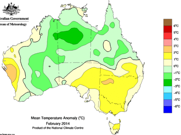
www.bom.gov.au/jsp/awap/temp/index.jsp?colour=colour&time=latest&step=0&map=meananom&period=week&area=nat
You will see BoM data indicates temperatures were similar 1.5m above the Australian land surface too.
See –
And then if you check the February mean anomaly charted –
You find it has dipped negative – has anybody expected that from reading anything in the media?