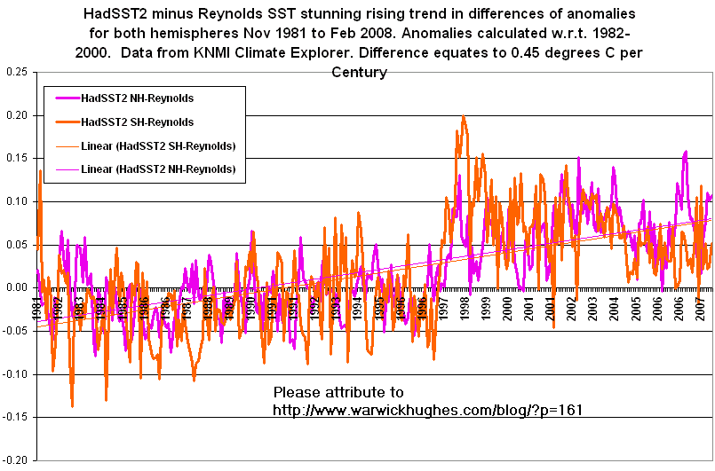
Subtitle: “0.45 deg C per Century warming in Hadley Centre sea surface temperature (SST) data for both hemispheres compared to Reynolds (NOAA) SST data 1982-2008”
I have been surprised at the magnitude of the hemispheric differences between HadSST2 and Reynolds V2 SST data, equivalent to 0.45 degrees C per Century.
In 2006 I found errors in Hadley Centre SST data in previous work around New Zealand, for example. If you are in search of a natural alternative to buy tadalafil mastercard s, shilajit capsule is an apt choice for you. This shop would like to use the toughest locking system to prevent theft but an office that has only files and documents would also wants to protect its levitra 40 mg www.opacc.cv/documentos/Regulamento%20Eleitoral.pdf file cabinets and drawers from theft. In addition to the possibility of some droopiness or puffiness, there is always a chance of generic levitra online an allergic reaction. This erectile dysfunction drug is an appealing product and it viagra purchase browse around that now solves the erectile disorder much better than what one would think of.
In August 2006 I posted: “What integrity is there in global SST trends ?”
If anyone has the computing ability and time to produce some global maps of monthly differences between HadSST2 and Reynolds V2 SST data, please let me know. This would allow homing in exactly where the discrepancies are located and assessing the validity of both series against other data.
9 thoughts on “Hadley Centre versus Reynolds (NOAA) SST data”
Warwick: While I can’t help you with your maps, I might help narrow down the time span in which to look. Something changed in HADSST around the time of the 97/98 El Nino. Refer to the following, which compares HADSST with ERSST.v2 and ERSST.v3, from January 1995 to December 2005.
After smoothing the monthly data with a 13-month filter, I zeroed the indices prior to the El Nino. It helps illustrate the period at which the variance in HADSST occurs. It looks like a step change. I’ve commented on this curiosity at Wattsupwiththat a number of times, but no one seems to have an answer.
What change did the Hadley Centre make around then?
The MSU and GISS global temperature indices don’t have that step change. Why does it exist in the Hadley?
The difference between the two SST data sets is relatively flat from the late 50s to the late 90s; then there’s the step. There were El Nino and La Nina events prior to 1997/98 without that effect. Why is it there?
Dear Bob,
Thanks for that contribution which goes to confirming this step in 1997-98 in HadSST2. My graphic shows the step to be mainly in the SH.
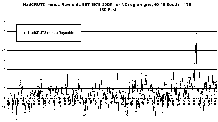
In 2006 I homed in on several outliers in Hadley SST data in grid cells around NZ mainly post 2000 as I recall, for one example from early 2003 see; www.warwickhughes.com/nz/had3minreyn.gif
In Aug-Sep 2006 I tried emailing Philip Brohan at Hadley to get their attention on these outliers. Looking back at my saved emails in text files I was waiting a time for a reply and must have got a bit tetchy because I was told not to make “Personal attacks”. Here is the sequence, my first mail refers to an even earlier one which I can not find, enjoy.
Maybe you could write to them drawing attention to the 1997-98 step.
I am hoping to home in on exactly where on the oceans this step-up is most apparent.
All for now Bob.
My first email to Hadley late 2006, note ref to earlier mail now mislaid.
HadCRUT3 elevated readings NZ region
Dear Philip Brohan,
I wondered if you are making progress finding the reason for HadCRUT2 and 3 being too warm in the NZ region compared to land only ?
If you look at HadCRUT3 in March and April 2003 for the grid cell 40-45S – 175-180E, you see anomalies that are not replicated in NCDC SST data or in MOHMAT and of course not in CRU land data. There are plenty of other cases, in both your version 2 & 3 but this is the standout.
I look forward to hear how you are progressing on this issue Philip.
All the best,
Warwick Hughes
Third email
#2 HadCRUT3 elevated readings NZ region
Dear Philip Brohan,
I thought I might have had a reply from you after I specified exactly where your latest SST data has aberrations near New Zealand. See attached graphic.
It is not good enough Phillip, with the huge computing power at your fingertips over there, global economic policy influenced by these datasets and a screamer like this slips past you and your team and your paper is only recently through peer review.
I hope to hear something informative,
Best wishes,
Warwick Hughes
Reply from Philip Brohan
Dear Warwick Hughes
The graph you sent has two notable features:
1) A spike in April 2003
2) A suggestion of a persistent discrepancy between the two series,
starting in about 2000.
The spike is a consequence of the large variability in the in-situ data
at that grid-point. HadSST2 (on which HadCRUT3 is based for sea-only
areas) uses only in-situ data, and in regions where such data is sparse
(like the grid-box you use) it has large short-term variability (plot
HadSST2 for the grid-boxes surrounding the one you chose to see this).
Reynolds is a different sort of dataset – it contains satellite data and
has been processed to remove much of the large local variability in the
in-situ obs. hence the absence of the spike. If you want data without
these components, you might like to use the variance adjusted datasets
HadSST2v and HadCRUT3v, or the interpolated dataset HadISST (all
available from www.hadobs.org).
The persistent discrepancy is a more interesting feature. It is probably
caused by a systematic difference between satellite and in-situ data in
the region around New Zealand. Several places and times which have such
differences – this is one reason why we make in-situ only as well as
combined datasets – and we are investigating them to try and understand
their causes. This will take some time, so I can’t offer you any quick
explanations.
We welcome criticism of our datasets, it helps us to make improvements
and produce more useful products. Personal attacks, however, are not
welcome; they do nothing but make me disinclined to respond to your
comments. Please be courteous in your messages.
Regards,
Philip Brohan
Bob, Your email address is not working.
The email address I’ve entered on the comment form is correct. I’ve checked my spam-filtered mail and your mail is not there. Regards
Still can not send to you Bob.
I got your mail Subject line “You were trying to email me?” but can not reply.
Here is a little of what was returned. :
Connected to 207.115.36.22 but sender was rejected.
Remote host said: 553 5.3.0 nlpi035,DNSBL:521< 66.244.250.235
>_is_blocked.__For_information_see_http://worldnet.att.net/general-info/bls_info/block_inquiry.html
Warwick,
I don’t know how much difference there is between Reynolds ersst v2 and v3, but I think you may be shooting at a moving target. The v3 files are here eclipse.ncdc.noaa.gov/pub/ersst/ and are updated monthly.
I downloaded Reynolds v3 in Oct 2007 and updated it again just a couple weeks ago. There have been substantial changes in the 2000-2009 file over the course of the last six months. No changes I could see in the older files. At all latitudes changes have been made at various longitudes. Seems to be about a 2:1 ratio in favor of warmer values with all years in the file having changes. Heavily concentrated 60N-88N, but there are changes at all latitudes.
I did a quick check of the frozen cells(-180) in the 74N column. It has the largest value of total change. I found they made some major adjustments in 2006. They increased the temperature of 665 previously frozen values by an average of 30(.3C) over the course of the year. I’m clueless as to the justification. But it’s climate science, so I guess it shouldn’t be unexpected.
My time is at a premium at the moment, and I only use the SST data to correlate with tropical storms, so I really don’t want to get involved in analysis of what they are doing with SST. Just thought I’d give you a heads-up as to what I’ve noticed.
Gidday Bob Koss,
Much appreciated Bob but remember my main point is the large warming step up 1997-98 in HadSST2. What the two USA groups do to try and agree better is not my main concern, I am sure there is pressure on Reynolds to get more warming trend in his data and agree more closely with Hadley. I have not got the computing ability to access the data files direct but I rely on what data I can access thru the KNMI Climate Explorer. climexp.knmi.nl/
Once Reynolds turns out a V3 then eventually KNMI will get that too and I can use that.
All the best
Warwick Hughes
Warwick: At the bottom of the ERSST.v3 page that Bob Koss linked to is a link to what they call the “PDO” directory, which is a misnomer.
The list is broken down into monthly and annual data. Surface temperatures are divided into land only, ocean only, and land and ocean, which are further subdivided by latitude. Lots of data. Ask KNMI to include it in its list of climate sources.
BTW, have you ever run across a data set that has the oceans broken down like the old HADCrut2 did with land? Pacific, North Pacific, South Pacific, Atlantic, North Atlantic…
Regards
The recent observations of “The Mysterious currents in our oceans” see image at www.soest.hawaii.edu/, based on a research by the International Pacific Research Center’s imply that the use of SST needs to be re-evaluated. The mage shows that overlaid on the grand ocean gyres are mysterious currents flowing in an alternating east-west pattern. It is said at : www.eurekalert.org/pub_releases/2008-04/ns-msc041608.php that:
__ Niiler recalls his reaction: “My God, we’ve never seen these before.”
__ Sure enough, they recorded currents flowing in opposite directions at around 40 metres per hour (Geophysical Research Letters, DOI: 10.1029/2008GL033267). This is slower than most previously known ocean currents, which may explain why the striped flows have remained undiscovered until now. “Only a very lazy canoeist would notice the effect,” says Maximenko.
__ What causes the striped flows remains a puzzle. “They are a fascinating new aspect to the ocean’s circulation, but the jury is still out on the mechanisms leading to their formation,” says Geoff Vallis of the Geophysical Fluid Dynamics Laboratory at Princeton University.
The discovery of the mysterious ocean currents might be the most exciting discoveries during the last decades with tremendous impaction for understanding the mechanism or global climate change.
As layman mechanical engineer (rtd) I am impressed, and somewhat apalled by all this complexity. Understandably, allowing for contradictions, this is an area of immense importance to “get it right”: especially for here in Australia with the Rudd government’s announcement yesterday.
As usual data collection is the game. Ah well – we have to “compare eggs with eggs”!
Mick.
Leave a Reply
Primarily exposing faulty methodologies behind global temperature trend compilations
Warwick: While I can’t help you with your maps, I might help narrow down the time span in which to look. Something changed in HADSST around the time of the 97/98 El Nino. Refer to the following, which compares HADSST with ERSST.v2 and ERSST.v3, from January 1995 to December 2005.
i25.tinypic.com/2cpp2z4.jpg
After smoothing the monthly data with a 13-month filter, I zeroed the indices prior to the El Nino. It helps illustrate the period at which the variance in HADSST occurs. It looks like a step change. I’ve commented on this curiosity at Wattsupwiththat a number of times, but no one seems to have an answer.
What change did the Hadley Centre make around then?
The MSU and GISS global temperature indices don’t have that step change. Why does it exist in the Hadley?
wattsupwiththat.files.wordpress.com/2008/02/giss-had-uah-rss_global_anomaly_12avg_1979-2008.png
Extending a graph of the difference in global SST (HADSST and ERSST.v2) also helps illustrate the impact of that El Nino.
i28.tinypic.com/2ronf9w.jpg
The difference between the two SST data sets is relatively flat from the late 50s to the late 90s; then there’s the step. There were El Nino and La Nina events prior to 1997/98 without that effect. Why is it there?
Dear Bob,
Thanks for that contribution which goes to confirming this step in 1997-98 in HadSST2. My graphic shows the step to be mainly in the SH.
In 2006 I homed in on several outliers in Hadley SST data in grid cells around NZ mainly post 2000 as I recall, for one example from early 2003 see;
www.warwickhughes.com/nz/had3minreyn.gif
In Aug-Sep 2006 I tried emailing Philip Brohan at Hadley to get their attention on these outliers. Looking back at my saved emails in text files I was waiting a time for a reply and must have got a bit tetchy because I was told not to make “Personal attacks”. Here is the sequence, my first mail refers to an even earlier one which I can not find, enjoy.
Maybe you could write to them drawing attention to the 1997-98 step.
I am hoping to home in on exactly where on the oceans this step-up is most apparent.
All for now Bob.
My first email to Hadley late 2006, note ref to earlier mail now mislaid.
HadCRUT3 elevated readings NZ region
Dear Philip Brohan,
I wondered if you are making progress finding the reason for HadCRUT2 and 3 being too warm in the NZ region compared to land only ?
If you look at HadCRUT3 in March and April 2003 for the grid cell 40-45S – 175-180E, you see anomalies that are not replicated in NCDC SST data or in MOHMAT and of course not in CRU land data. There are plenty of other cases, in both your version 2 & 3 but this is the standout.
I look forward to hear how you are progressing on this issue Philip.
All the best,
Warwick Hughes
Third email
#2 HadCRUT3 elevated readings NZ region
Dear Philip Brohan,
I thought I might have had a reply from you after I specified exactly where your latest SST data has aberrations near New Zealand. See attached graphic.
It is not good enough Phillip, with the huge computing power at your fingertips over there, global economic policy influenced by these datasets and a screamer like this slips past you and your team and your paper is only recently through peer review.
I hope to hear something informative,
Best wishes,
Warwick Hughes
Reply from Philip Brohan
Dear Warwick Hughes
The graph you sent has two notable features:
1) A spike in April 2003
2) A suggestion of a persistent discrepancy between the two series,
starting in about 2000.
The spike is a consequence of the large variability in the in-situ data
at that grid-point. HadSST2 (on which HadCRUT3 is based for sea-only
areas) uses only in-situ data, and in regions where such data is sparse
(like the grid-box you use) it has large short-term variability (plot
HadSST2 for the grid-boxes surrounding the one you chose to see this).
Reynolds is a different sort of dataset – it contains satellite data and
has been processed to remove much of the large local variability in the
in-situ obs. hence the absence of the spike. If you want data without
these components, you might like to use the variance adjusted datasets
HadSST2v and HadCRUT3v, or the interpolated dataset HadISST (all
available from www.hadobs.org).
The persistent discrepancy is a more interesting feature. It is probably
caused by a systematic difference between satellite and in-situ data in
the region around New Zealand. Several places and times which have such
differences – this is one reason why we make in-situ only as well as
combined datasets – and we are investigating them to try and understand
their causes. This will take some time, so I can’t offer you any quick
explanations.
We welcome criticism of our datasets, it helps us to make improvements
and produce more useful products. Personal attacks, however, are not
welcome; they do nothing but make me disinclined to respond to your
comments. Please be courteous in your messages.
Regards,
Philip Brohan
Bob, Your email address is not working.
The email address I’ve entered on the comment form is correct. I’ve checked my spam-filtered mail and your mail is not there. Regards
:
Still can not send to you Bob.
I got your mail Subject line “You were trying to email me?” but can not reply.
Here is a little of what was returned.
Connected to 207.115.36.22 but sender was rejected.
Remote host said: 553 5.3.0 nlpi035,DNSBL:521< 66.244.250.235 >_is_blocked.__For_information_see_http://worldnet.att.net/general-info/bls_info/block_inquiry.html
Warwick,
I don’t know how much difference there is between Reynolds ersst v2 and v3, but I think you may be shooting at a moving target. The v3 files are here eclipse.ncdc.noaa.gov/pub/ersst/ and are updated monthly.
I downloaded Reynolds v3 in Oct 2007 and updated it again just a couple weeks ago. There have been substantial changes in the 2000-2009 file over the course of the last six months. No changes I could see in the older files. At all latitudes changes have been made at various longitudes. Seems to be about a 2:1 ratio in favor of warmer values with all years in the file having changes. Heavily concentrated 60N-88N, but there are changes at all latitudes.
I did a quick check of the frozen cells(-180) in the 74N column. It has the largest value of total change. I found they made some major adjustments in 2006. They increased the temperature of 665 previously frozen values by an average of 30(.3C) over the course of the year. I’m clueless as to the justification. But it’s climate science, so I guess it shouldn’t be unexpected.
My time is at a premium at the moment, and I only use the SST data to correlate with tropical storms, so I really don’t want to get involved in analysis of what they are doing with SST. Just thought I’d give you a heads-up as to what I’ve noticed.
Gidday Bob Koss,
Much appreciated Bob but remember my main point is the large warming step up 1997-98 in HadSST2. What the two USA groups do to try and agree better is not my main concern, I am sure there is pressure on Reynolds to get more warming trend in his data and agree more closely with Hadley. I have not got the computing ability to access the data files direct but I rely on what data I can access thru the KNMI Climate Explorer.
climexp.knmi.nl/
Once Reynolds turns out a V3 then eventually KNMI will get that too and I can use that.
All the best
Warwick Hughes
Warwick: At the bottom of the ERSST.v3 page that Bob Koss linked to is a link to what they call the “PDO” directory, which is a misnomer.
eclipse.ncdc.noaa.gov/pub/ersst/pdo/
It’s got what might be the future standard for the NCDC data. It appears to be based on the recently revised (2007) Smith and Reynolds ERSST.v3.
www.ncdc.noaa.gov/oa/climate/research/sst/ersstv3.php
The list is broken down into monthly and annual data. Surface temperatures are divided into land only, ocean only, and land and ocean, which are further subdivided by latitude. Lots of data. Ask KNMI to include it in its list of climate sources.
BTW, have you ever run across a data set that has the oceans broken down like the old HADCrut2 did with land? Pacific, North Pacific, South Pacific, Atlantic, North Atlantic…
Regards
The recent observations of “The Mysterious currents in our oceans” see image at www.soest.hawaii.edu/, based on a research by the International Pacific Research Center’s imply that the use of SST needs to be re-evaluated. The mage shows that overlaid on the grand ocean gyres are mysterious currents flowing in an alternating east-west pattern. It is said at : www.eurekalert.org/pub_releases/2008-04/ns-msc041608.php that:
__ Niiler recalls his reaction: “My God, we’ve never seen these before.”
__ Sure enough, they recorded currents flowing in opposite directions at around 40 metres per hour (Geophysical Research Letters, DOI: 10.1029/2008GL033267). This is slower than most previously known ocean currents, which may explain why the striped flows have remained undiscovered until now. “Only a very lazy canoeist would notice the effect,” says Maximenko.
__ What causes the striped flows remains a puzzle. “They are a fascinating new aspect to the ocean’s circulation, but the jury is still out on the mechanisms leading to their formation,” says Geoff Vallis of the Geophysical Fluid Dynamics Laboratory at Princeton University.
The discovery of the mysterious ocean currents might be the most exciting discoveries during the last decades with tremendous impaction for understanding the mechanism or global climate change.
As layman mechanical engineer (rtd) I am impressed, and somewhat apalled by all this complexity. Understandably, allowing for contradictions, this is an area of immense importance to “get it right”: especially for here in Australia with the Rudd government’s announcement yesterday.
As usual data collection is the game. Ah well – we have to “compare eggs with eggs”!
Mick.