Vose et al provide two examples of discrepancies “to illustrate the typical causes involved”. The first, centred over the southern tip of the Baja California, involves a trend difference of 0.776 degrees per decade. This means that, over this part of the earth, the CRU series exhibits a temperature trend that is 2.10 degrees higher than shown by the GHCN over
the period 1976-2003.
“The second problematic box” addressed by Vose et al is centred near
southern California (incl L.A.), which has one of the densest networks of high-quality
temperature measurement stations in the world. Here there is a large
discrepancy in the opposite direction. The GHCN record has trend warming of
0.796 degrees per decade higher than the CRU record, or 2.15 degrees over
the period of record.
We tried to obtain station data for CRU so we could assist the authors of Vose et al with our analysis but were denied the station data.
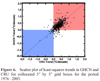
It soon became clear that this clever use of the calming number 9.4% was in fact concealing the fact that a vastly greater number of grid points varied by more than 0.1 degree C per decade, regardless of sign. Vose et al are trying to show that GHCN and CRU are similar, so it does not matter if for any grid point one or the other is higher, it is DIFFERENCE that is the issue, so sign is a red herring.
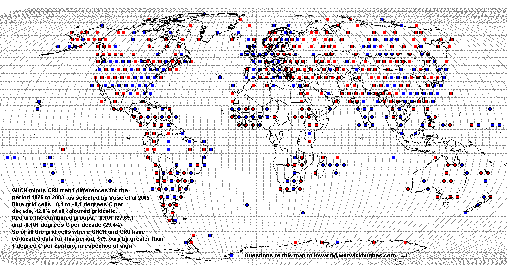
So, 57% of grid points differ by greater than the magnitude of century long global warming.
It looks to me as though any agreement between GHCN and CRU at the grid point level over the period 1976-2003 is simply due to the sum of all errors tending to approach zero.
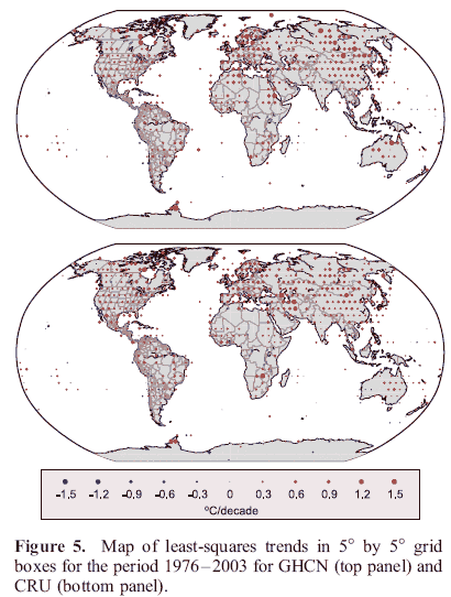
North America would have the largest area of high quality climate data on earth, yet look at the stunning differences in many grid cells. Click on the USA for our Global map.
Feb 2010 my submission to UK House of Commons select committee, note my Fig 2 map showing grid points for which GHCN has NO data and also grid points where CRU has NO data. The 57% referred to above is 57% of the remaining grid points where both datsets have data in the file Russell Vose sent me. So it is clear the percentage of total global grid points for which the two datasets strongly disagree is much more than 57%.
My point is that the point often made by Jones and Edward Acton the University of East Anglia Vice Chancellor; that people seeking station data should go to NOAA (GHCN) - is very misleading. Data behind the Vose et al paper, co-authored by Jones, shown in Fig 5 above, reveals that the datasets CRU and GHCN are very different - and that is over the 1976-2003 period chosen by Vose et al to demonstrate "close agreement".
Facts are that there are layered attempts to mislead by the "great and good" of climate science and their supporters.