(2) SHORT TERM RECORDS
Jones et al 1986 looked at 86 Australian stations and rejected 46
(25 Short term – 21 long term). Of the 40 they used 27 were short term
and 13 long term. Of the long term there were 5 large cities.
The 27 short term stations were mostly only quoted from 1951 onward –
regardless of what data was available. It just so happens that the
years just post WWII were not prominently warm in Australia so an
“automatic” warming trend was reinforced into the CRU Australian
component.
Here are 11 examples where Jones et al systematically truncated
pre-1951 data or ignored more rural data around many small town
Australian stations. These graphics and text have been extracted from a
1992 vintage Word doc that somehow survived the decades and how many
HDD’s. Note 27 Nov 09 to clear up any ambiguity – check my comment
(WSH) 17 below.
`
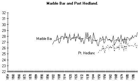
Port Hedland
The aerodrome records 1951-80 shows a clear warming trend. Marble Bar,
150 kms south east, shows a similar trend over that period but a flat
trend over 80 odd years.
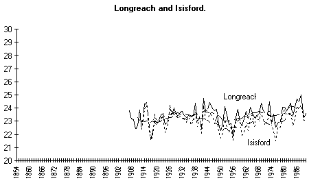
Longreach
For the period 1951-80 this trend is sharply upward, yet if the
Longreach Post Office record is spliced to the aerodrome record (post
1940s) the trend becomes markedly flatter. When Longreach is compared
to Isisford, a much smaller rural centre 80 kms south, the trend is
closer to neutral over about 70 years.
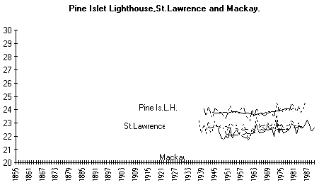
Mackay
The A.M.O. record 1951-80 shows a clearly steeper warming trend for
Mackay when compared with St Lawrence and Pine Islet Lighthouse.
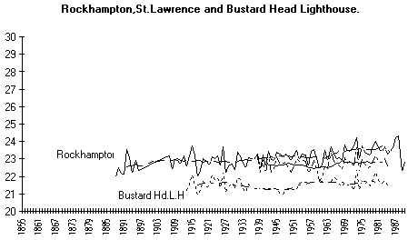
Rockhampton
Compared to Bustard Head Lighthouse and St. Lawrence, Rockhampton shows
a warming trend of about 0.5°C over 70 years. Rockhampton data was
used
only for the period 1951-1970. The two nearby more rural sites show a
similar temperature pattern but a negligible temperature change over 70
years.
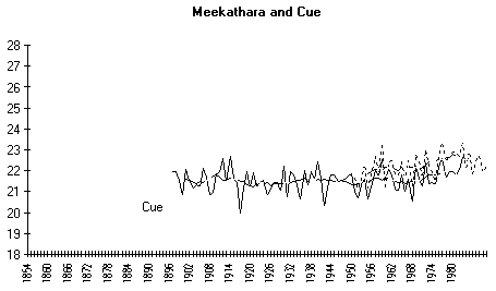
Meekathara
The Aerodrome record 1951-80 shows a clear strong warming trend. The
small centre of Cue, 120 kms south west however has a flat trend over
90 years.
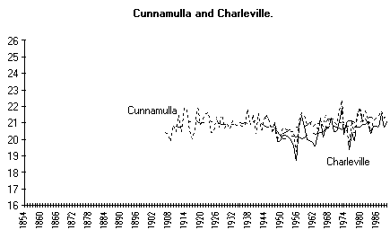
Charleville
The trend for this station 1951-80 also shows a strong warming trend.
Cunnamulla, a smaller centre approximately 170 kms south, shows a much
flatter trend over about 80 years.
Kalgoorlie
The aerodrome record 1941-80 shows a well defined warming. However,
when Post Office records are spliced on, the trend is much closer to
zero over 90 years. Looking at Southern Cross, a continuous Post Office
record, approximately 200 kms west, the trend is very similar, flat
over some 90 years.
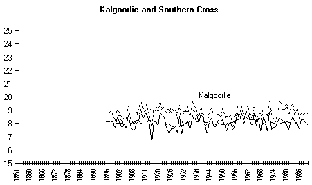
www.warwickhughes.com/cru86/tr027/kalgoorlie.gif
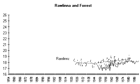
Forrest
This station 1951-80, shows a steeper warming trend than the nearby
Rawlinna, where records go back to 1926.
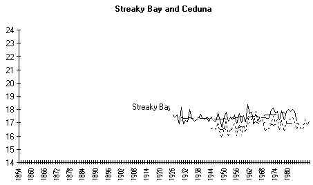
Ceduna
A warming trend is seen over the 1951-80 period, yet the longer term
and more remote Streaky Bay, where records are available back to 1925,
shows a flatter trend.
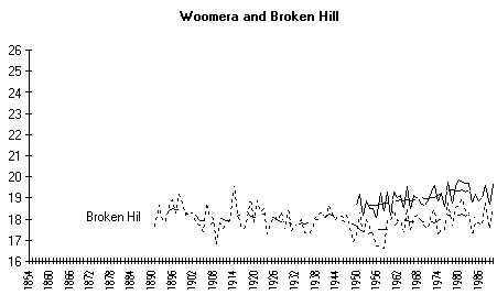
Woomera
Once again, this record shows the 1951-80 warming. Broken Hill, the
nearest long term station in a similar climate, shows a cooling trend
over a hundred year time span.
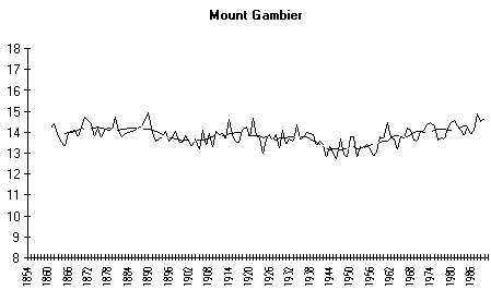
Mt. Gambier
From 1951-80 this aerodrome station shows a strong warming trend. When
the Post Office records are spliced on the trend 1860s to 1990, it is
close to neutral.