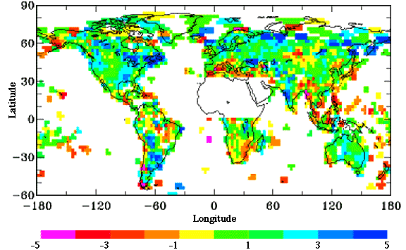
NASA's Goddard Institute for Space Studies in New York puts on the internet
the following map of global rainfall anomalies for the last century.
The map makes it clear that in the lottery of constantly changing climate,
many regions have had rainfall declines equivalent to SW WA or greater
and conversely many regions have enjoyed increasing rain, for example much
of Eastern Australia. Much of the globe seems to have had slightly
increased rain over the last 100 years.
Bureau of Meteorology High Quality Rain Data
The Bureau of Meteorology (BoM) collects and archives Australian rain
data.
In 1992 BoM staff published a survey of Australian rainfall data, Nicholls,
N. And Lavery, B.M., 1992 Australian Rainfall Trends in the Twentieth Century,
Int. J. Climatology, 12 153-163, and Lavery, B.M., Kariko, A.P., and Nicholls,
N., 1992
A High-quality historical rainfall data set for Australia, Aust. Met.
Mag., 40, pp33-39.
This filtered out 191 stations that were "high quality" over the history
of the data thus suitable to generate a long term trend on the basis of
less data gaps, statistical testing and station histories. A few years
later this list was increased to 379 and these data updated through 1995
are available as monthly totals for download on the BoM ftp site.
A point of relevance to any discussion re Perth's rainfall history is
that none of these high quality data are from the greater Perth region or
supply dam catchment areas. This leads to the point that to be in
the best position to make any scientific statements about Perth rainfall
history one would ideally first undertake a new statistical analysis of
the regions data.
No report on this subject is apparent looking over The Water Corporation
web site.
In recent media advertisements headed "Dam Update" The Water Corporation
relates dam inflow data to Perth rainfall for this year when it is obvious
that catchment area rain data is better related to stream inflow.
GHCN Global Rainfall Data
Another survey filtering out a high quality rainfall data set for Australia
is that carried out globally by United States climate groups National Oceanic
and Atmospheric Administration (NOAA) and National Climatic Data Center
(NCDC) as part of their Global Historical Climate Network survey in the mid
1990's. The GHCN survey has more stations
included than the 379 of the BoM so presumably used less demanding statistical
testing. These data can be downloaded from their site.
General points on rainfall data
Rain data can be difficult to analyse statistically because it tends to
be very "noisy" with large variations between years and typically
few years are actually near average. Also neighbouring stations can vary
significantly which just adds to the problem if you are trying to filter
out non-climatic trends or drifts.
Rainfall readings can be affected by structures or vegetation changing
near the rain guage and if these changes are progressive over years then
drifts can be produced in data and because the data is noisy, the drifts
are not easy to detect.
Sudden changes like a new building or clearing nearby trees can produce
a sudden jump in data.
Composite graphic of Perth and catchment region annual
rainfall in mm
The following graphic gives a fair impression of the Perth region
rainfall history with reservations that the Perth Regional Office was moved
several times. Note that the rainfall scale starts at 500 mm.
More updated catchment area data is being sought and will be posted when
available.
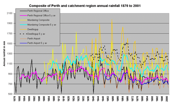
Note that Dwellingup and Mundaring data are more "noisy" than Perth so
the low rain in 2001 for Dwellingup is on scale with past years, not quite
as low as 1940.
Interesting to note how pre-1900 Perth rain went through periods
comparable with recent times so perhaps the "climate change" so much
chattered about could be seen as a return to an earlier climate. It
will be interesting to see if the pre-1900 Perth data stands up in other
regional comparisons.
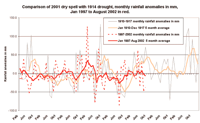
We have to face the facts that;
The Government is claiming we are in the "..worst drought since 1914..".
This is another example of Government misinformation in this whole "water
crisis". It is utter nonsense, 2001 was a moderately dry year in the Perth
region, in fact looking at Perth rainfall records 2001 was only the 15th
dryest year.
Click for graphic comparing the 1914 drought
with 2001, you can see the 1914 negative rain anomaly was much deeper
than in 2001.
Back to PerthWater
front page