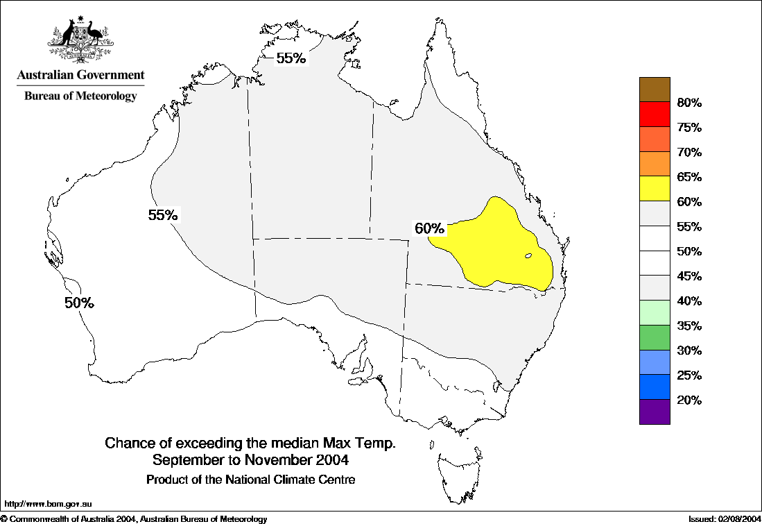
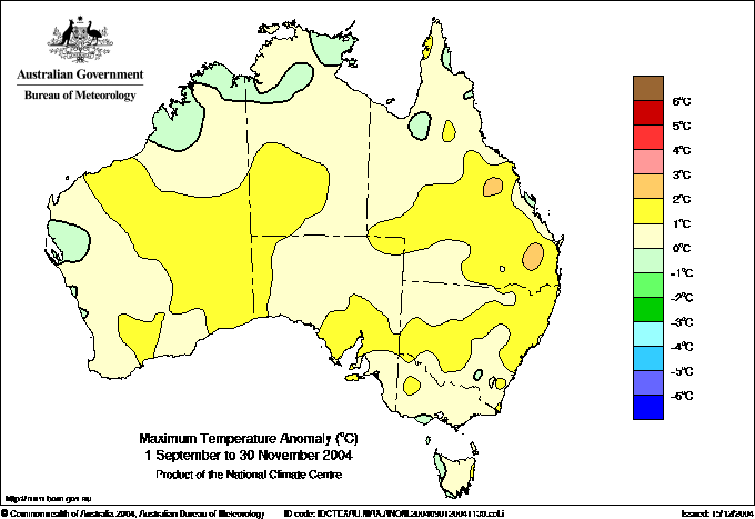
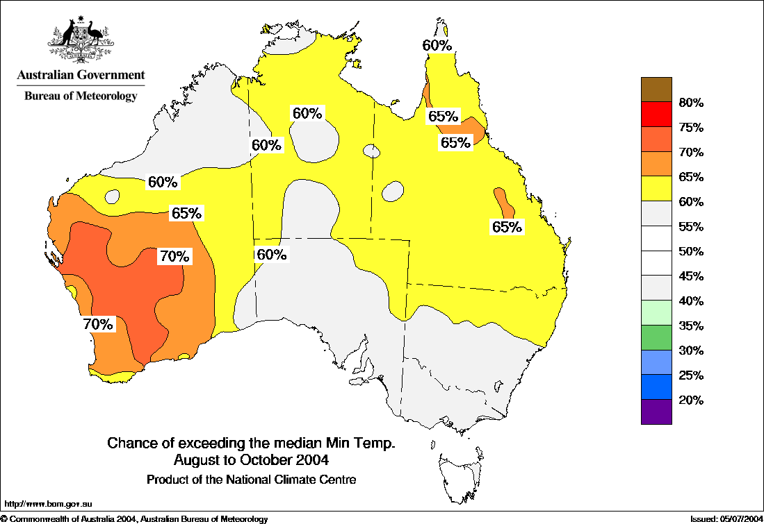
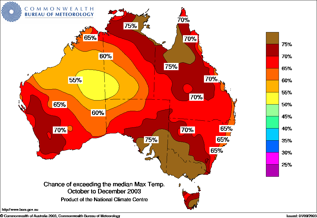
Maximum temperature Outlook Map for October to December 2004 published by BoM mid September 2004."Increased warmth favoured for much of eastern and southern Australia", says BoM. My comments; Additional to the BoM headline there is clearly a predicted slight cool anomaly in northern WA / west NT.
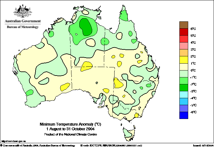
Actual temperature anomaly maps from the BoM four months after the corresponding Outlook and my comments.
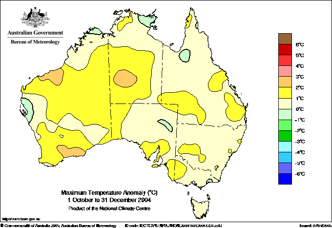
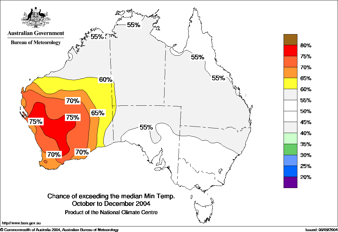
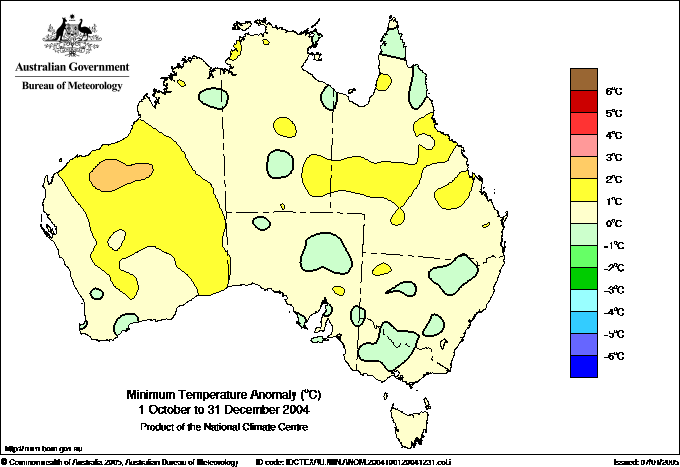
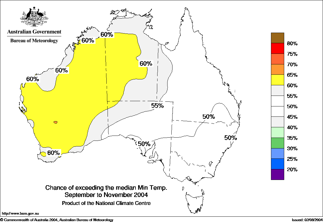
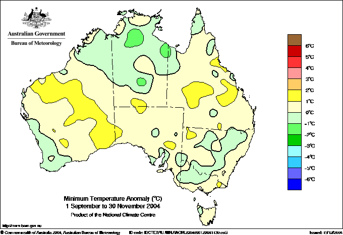
Observed maximum temperature anomalies October to December 2004, published mid January 2005. Instead of the predicted warm axis across the south as modelled in the September "Outlook" the EXACT OPPOSITE has happened in that the main axis of warming is in the NORTHERN half of the continent, not the SOUTHERN. It gets worse for the BoM because the prediced sl cool anomaly in northern WA / west NT turned out to be part of the MAIN WARM anomaly. To be fair SW WA and much of SE & E Aust are passable. Maybe a 40% overall.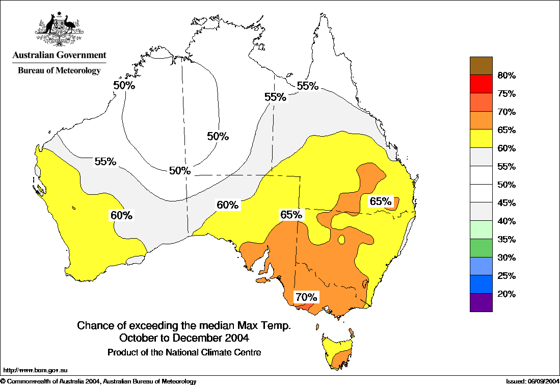
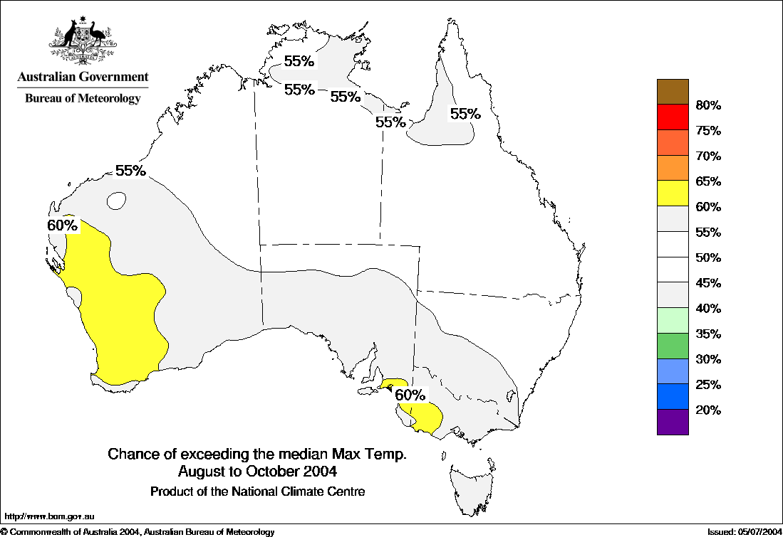
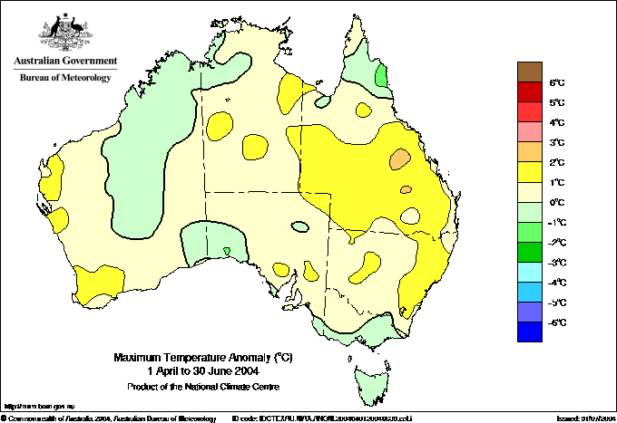
Comments; Hot in west, warm in north a simple predicted gradient to cool south east.
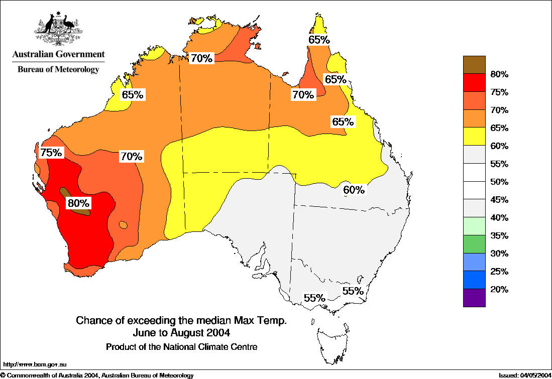
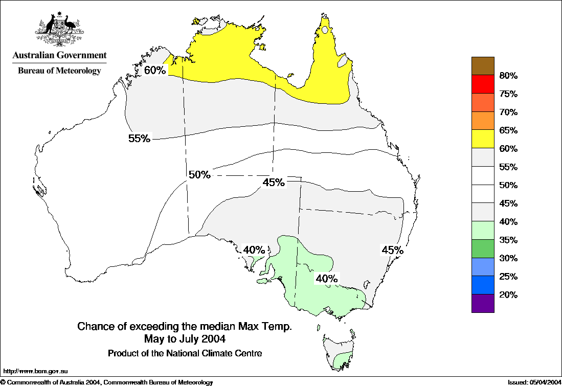
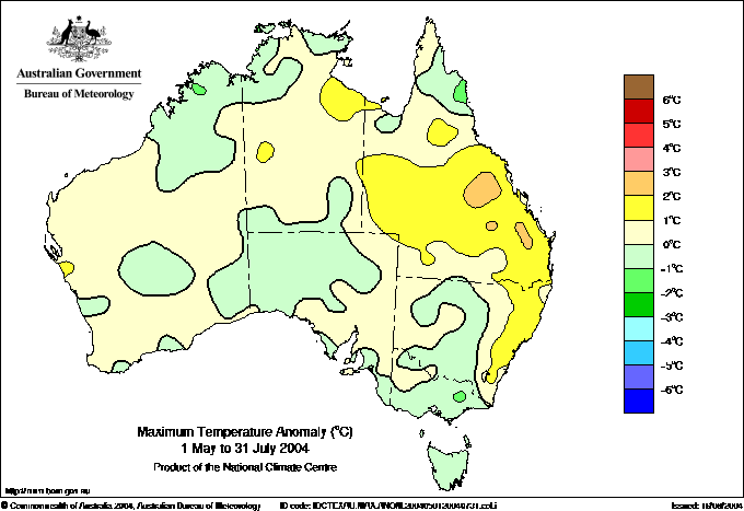
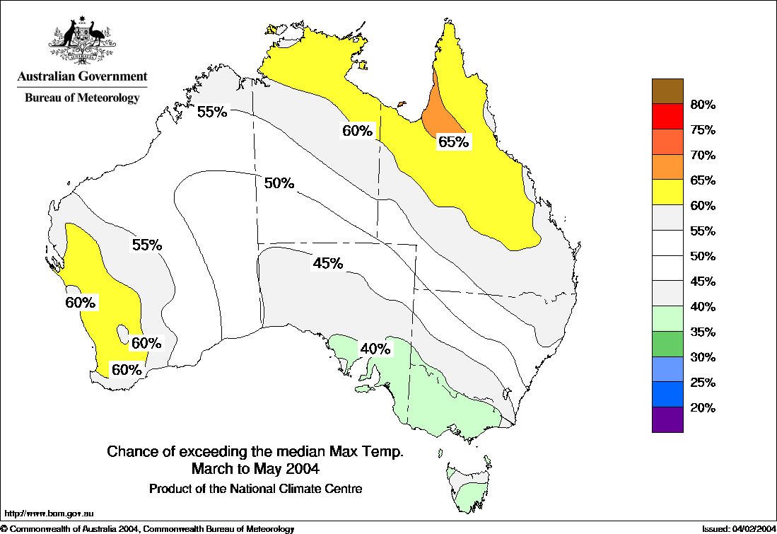
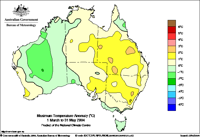
Maximum temperature Outlook Map for May to July 2004 published by BoM mid April 2004. "Cooler in the southeast, warmer in the far north.", says the BoM.
Comments; Except for WA, a simple predicted gradient from the warm north to cool south.
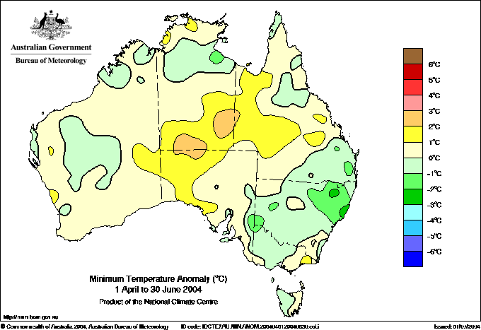
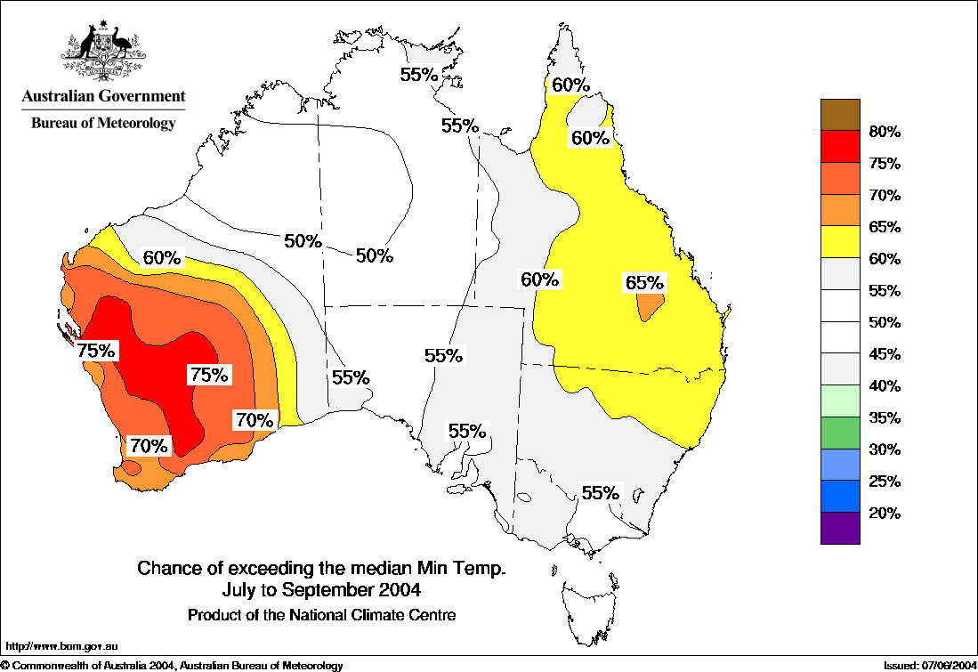
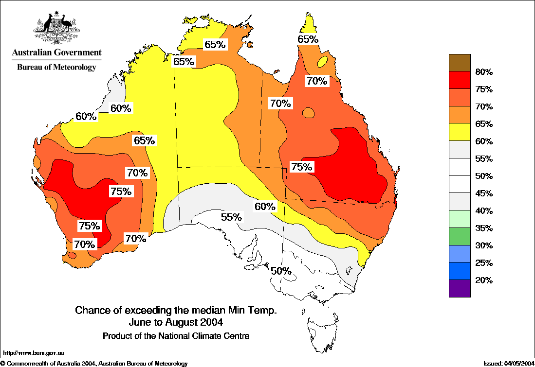
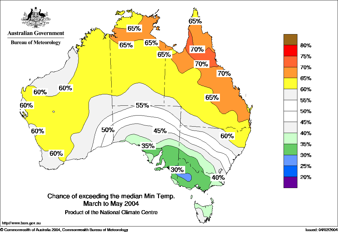
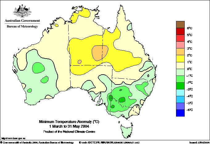
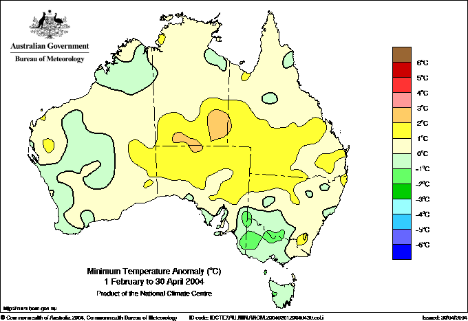
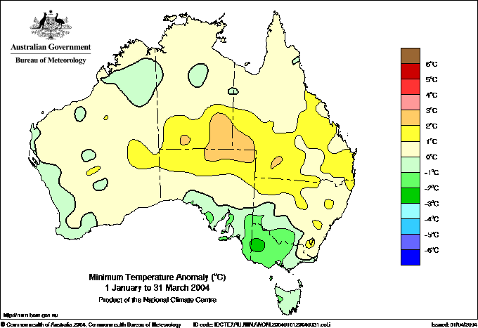
Minimum temperature Outlook Map for March to May 2004 published by BoM 17, February 2004. Comments; Gradient from N to S in east.
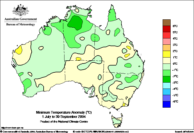
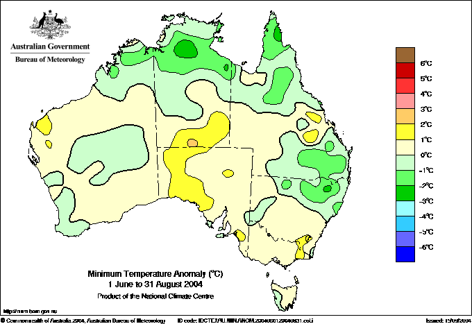
Observed minimum temperature anomalies for March to May 2004. Comments: SA Vic OK, S WA exactly wrong, no sign of predicted warm Cape York to Qld coast. Tas OK. Warm high east of centre not predicted.
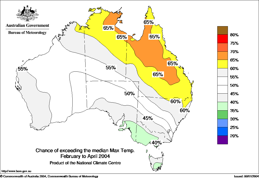
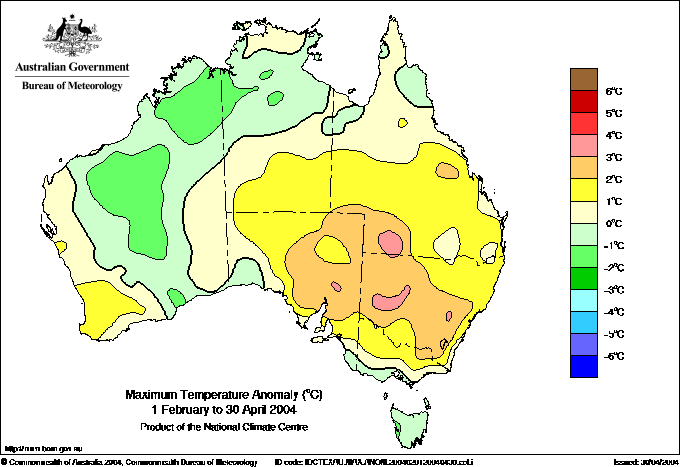
Maximum temperature Outlook Map for February to April 2004 published by BoM 15, January 2004. Comments; there are two main features here , a warm axis extending SE from Darwin and a cool axis extending NW from Tasmania.
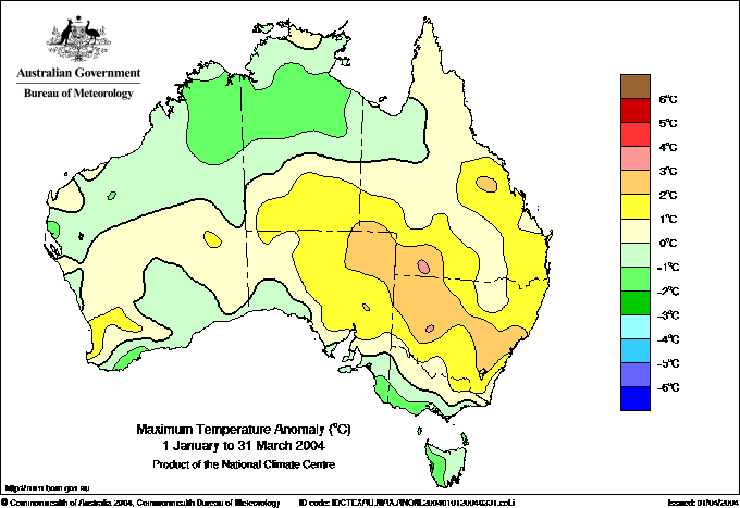
Observed maximum temperature anomalies for February to April 2004. Comments the warm axis is displaced about 1000 km to the SW and the cool axis flexes through 90 degrees. Hardly a ringing success.
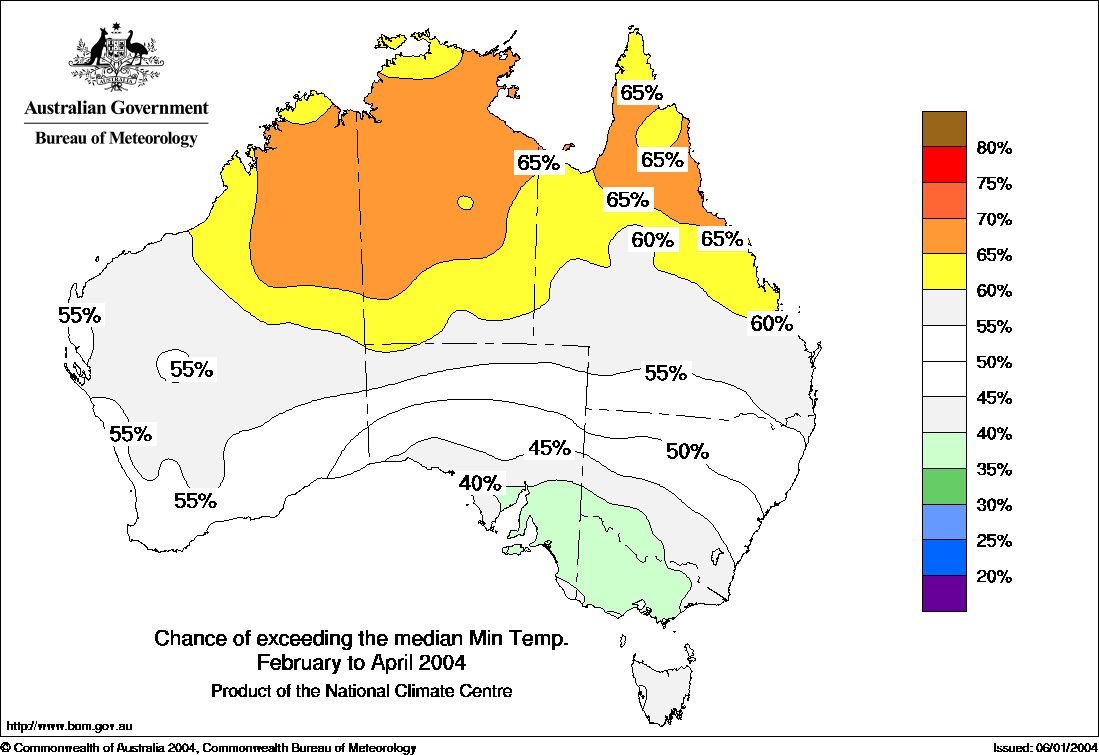
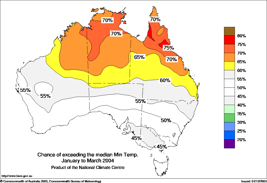
Minimum temperature Outlook Map for February to April 2004 published by BoM 15, January 2004. Comments; there are two main features here , a warm patch in the top end and a cool area around western Victoria.
Observed minimum temperature anomalies for February to April 2004. Comments: The warm patch in top end is displaced to centre of continent but the cool area over western Victoria is v good.
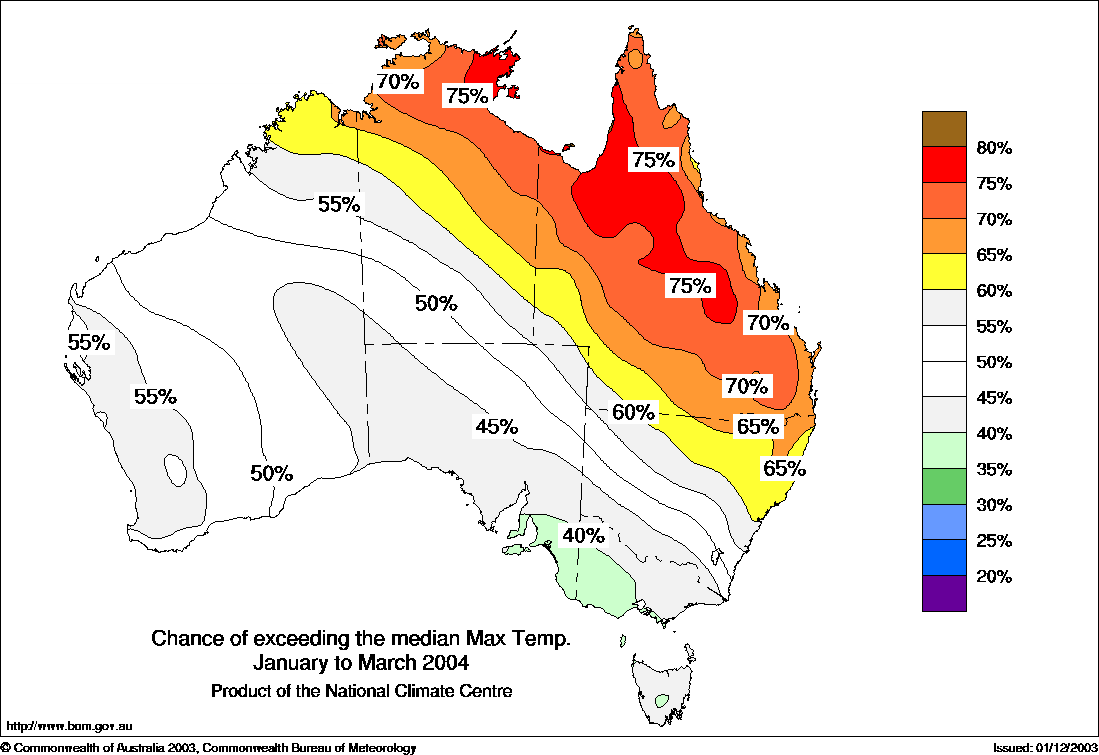
Maximum temperature Outlook Map for January to March 2004 published by BoM 16 December 2003 Comments; there are two main features here , a warm axis extending SE from Darwin and a cool axis extending NW from Tasmania.
Observed maximum temperature anomalies for January to March 2004. Comments: The huge cool patch in NT north WA was not forseen. The predicted warm patch in top end is displaced to SE of continent but the cool area over southern & western Victoria is v good.
Minimum temperature Outlook
Map for January to March 2004 published by BoM 16, December
2003 Comments;The main feature, a warm top
end.
Observed minimum temperature anomalies for January to March 2004. Comments: The warmth predicted for top end actually happened in the centre. Top end is actually average to cool, the cool area over western Victoria is much deeper than hinted at in the "Outlook" which only showed a cooling gradient.
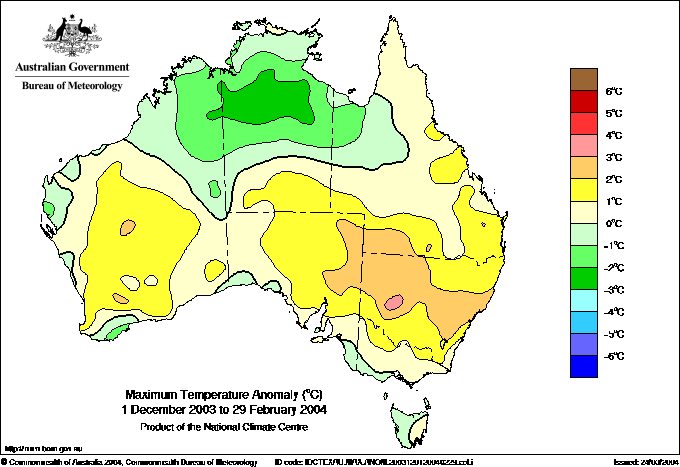
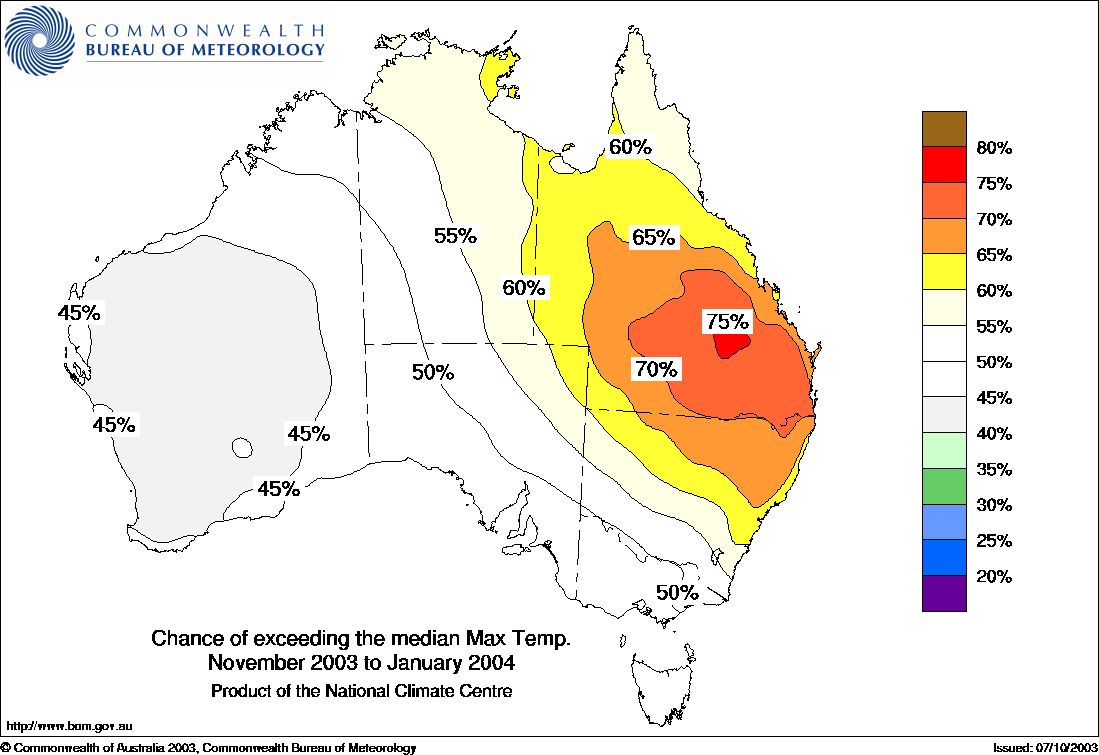
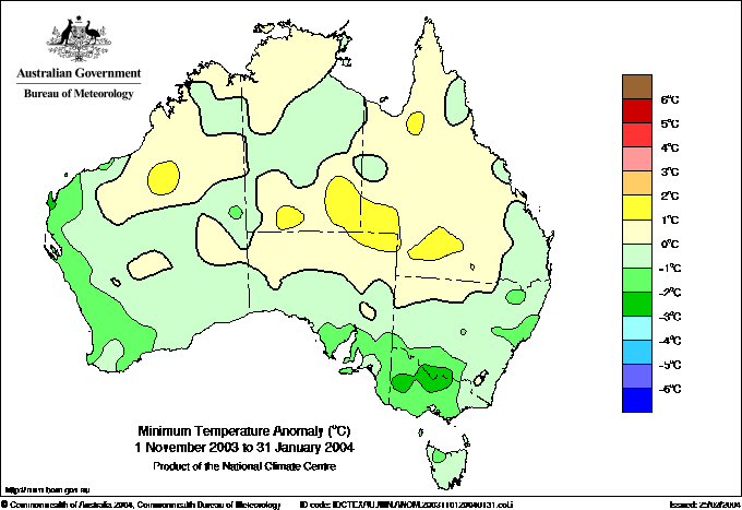
Maximum temperature Outlook Map for December to February 2004 published by BoM 14 November 2003 Comments;How any savvy scientific group could put out an "outlook" like this is beyond my ken. How often has Australia produced three monthly observations as flat as this ?
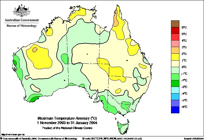
Observed maximum temperature anomalies for December to February 2004. Comments: The "Outlook" prediction completely missed the two main observed features.
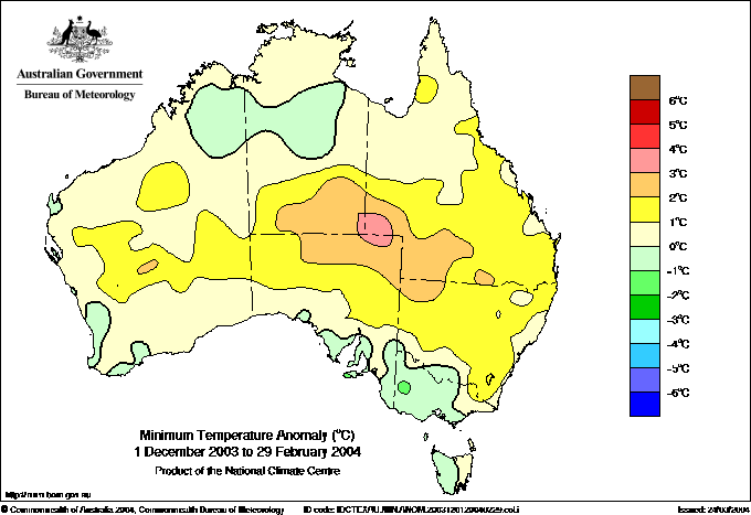
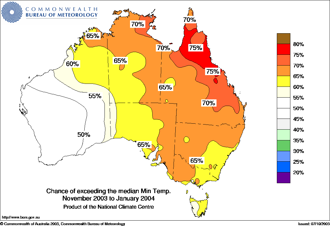
Minimum temperature Outlook Map for December to February 2004 published by BoM 14, November 2003. Comments; The warm top end dominates this "Outlook".
Observed minimum temperature anomalies for December to February 2004 . Comments: The warm patch in top end is displaced to centre of continent and replaced by a cool anomaly. Could any result be as wrong ? The cool in Victoria was not hinted at in the "Outlook".
Maximum temperature Outlook Map for November to January 2004 published by BoM 16 October 2003 Comments;Simple pattern, warm over SE Qld, steady cooler gradient to west.
Observed maximum temperature anomalies for November to January 2004. Comments: Some points for general Qld warmth but missed Cape York, Pilbara and and the cooler coast from west to Vic.
Minimum temperature Outlook Map for November to January 2004 published by BoM 16 October 2003 Comments;Simple pattern, warm over coastal N Qld to Cape York, cooler gradient to west.
Observed minimum temperature anomalies for November to January 2004. Comments: Nothing like the "Outlook" which completely missed the location of the mild warm axis thru centre and cooler SW WA and SA-Vic.
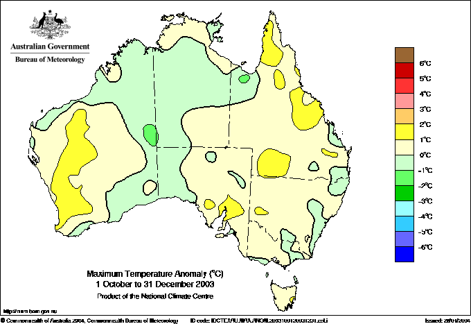
Maximum temperature Outlook Map for October to December 2003 published by BoM 16 September 2003 Comments; Prominently much above average, extreme warm over Top End and S SA-Vic.
Observed maximum temperature anomalies for October to December 2003 . Comments: Turned out markedly cooler. Some marks for S WA pattern if not magnitude, ditto central WA relatively cooler. V poor result for Eastern states.
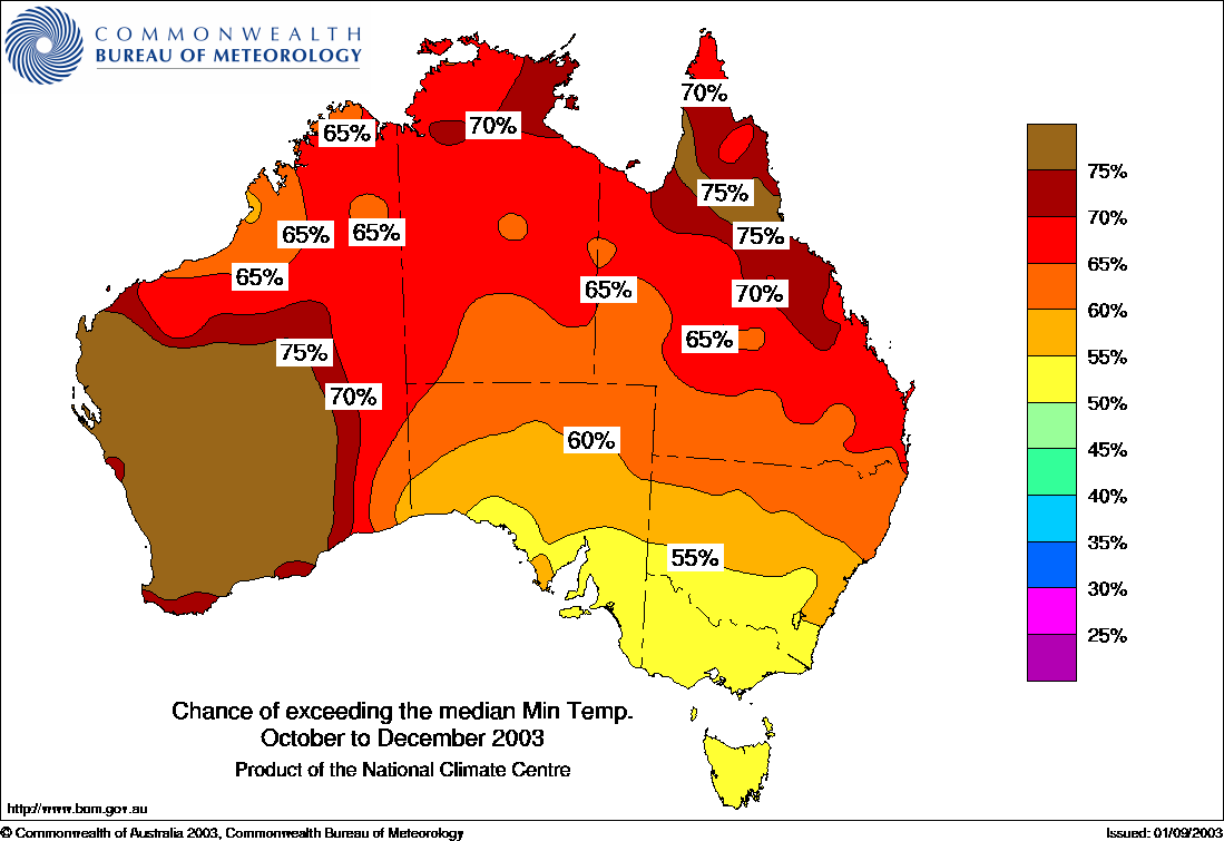
Minimum temperature Outlook Map for October to December 2003 published by BoM 16 September 2003 Comments;Model on steroids, major overall warmth predicted.
Observed minimum temperature anomalies for October to December 2003 . Comments: No sign of SW Qld warm patch in model, no sign of Kimberleys cool area in model. How can they predict so warm so often and be wrong. Yet the real world so often just oscillates nearer average
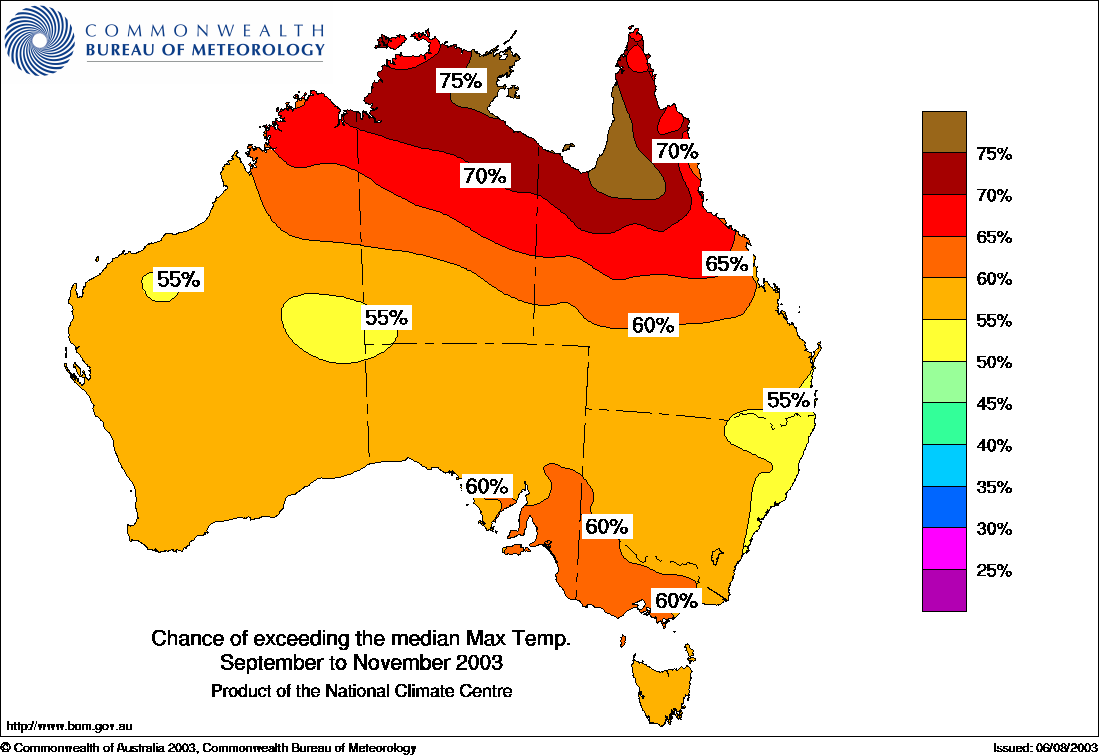
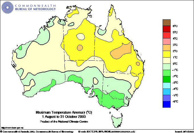
Maximum temperature Outlook Map for September to November 2003 published by BoM 19 August 2003. Comments; Extreme warm over Top End and warm S SA-Vic.
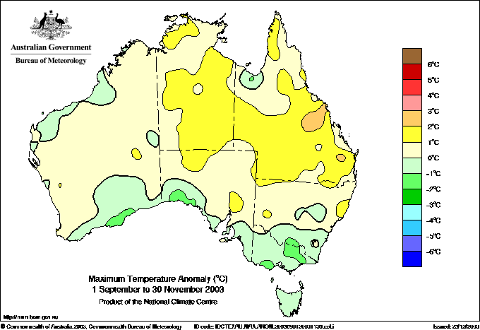
Observed maximum temperature anomalies for September to November 2003. Comments: Some points for general Qld warmth but predicted Cape York extreme warmth missed the bus. S SA and Vic exactly wrong as is Tas.
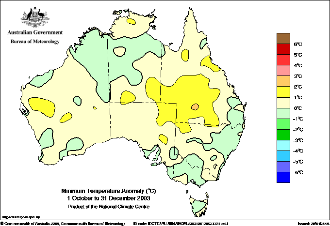
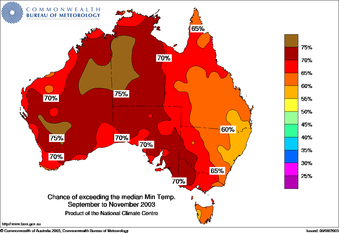
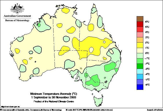
Minimum temperature Outlook Map for September to November 2003 published by BoM 19 August 2003. Comments;Model on steroids again, major overall warmth predicted.
Observed minimum temperature anomalies for September to November 2003. Comments: How many times does the model predict too warm overall before they learn ? The patterns are so much at odds with prediction that you have to ask, what is the use ?
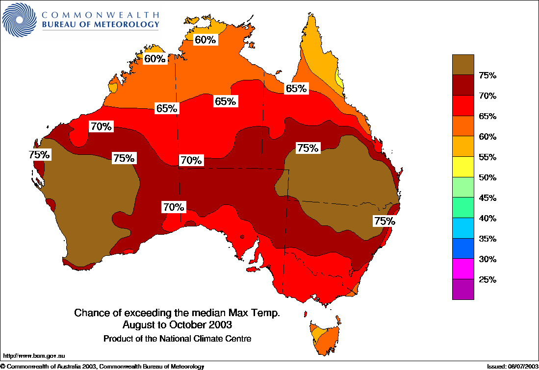
Maximum temperature Outlook Map for August to October 2003 published by BoM 16 July 2003. Comments; Prominently much above average, extreme warm over S WA and S Qld N NSW.
Observed maximum temperature anomalies for August to October 2003. Comments: Huge loss of points for turning out near average overall. Some points for general Qld warmth. The model totally missed cooler Pilbara and the prominently cooler coast from west to Vic. S WA NOT hot. Tas wrong again.
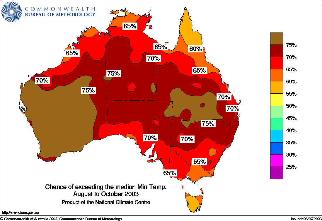
Minimum temperature Outlook Map for August to October 2003 published by BoM 16 July 2003. Comments;Model on steroids again, major overall warmth predicted and that dipole effect persists.
Observed minimum temperature anomalies for August to October 2003. Comments: The warm patch in Qld is not where model predicted but worth 60% for Qld say. S WA NOT hot again ? Vic NSW cool not predicted. Tas wrong again.
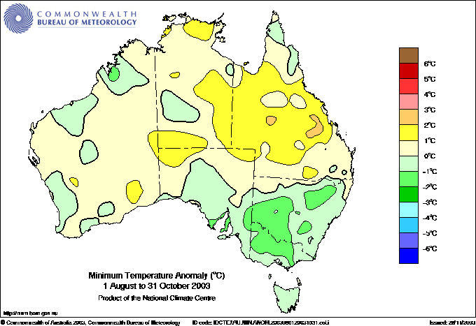
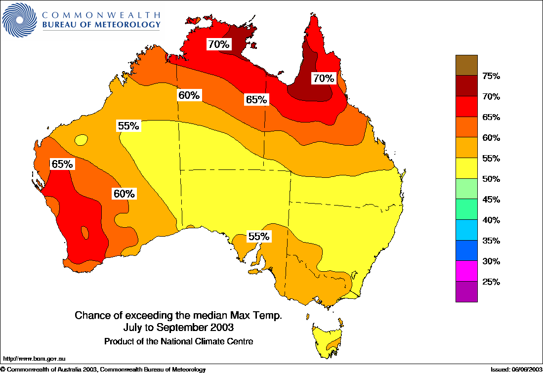
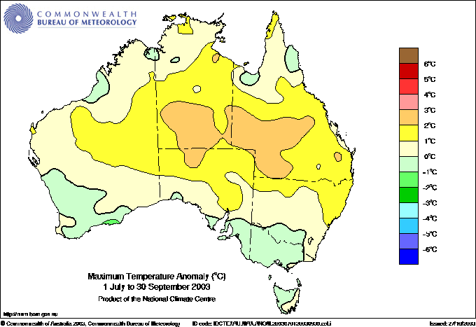
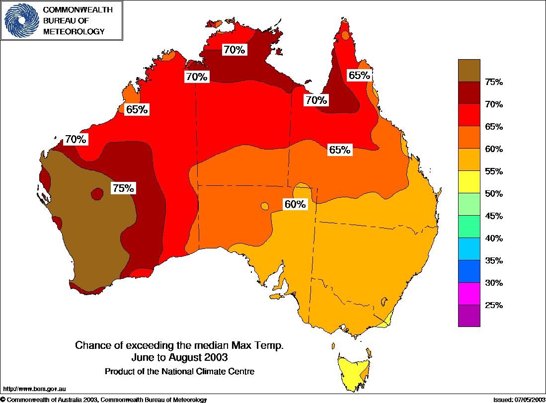
Maximum temperature Outlook Map for July to September 2003 published by BoM 17 June 2003. Comments; Above average overall again, extreme warm over Top End. East plunging cooler trough extends thru NSW.
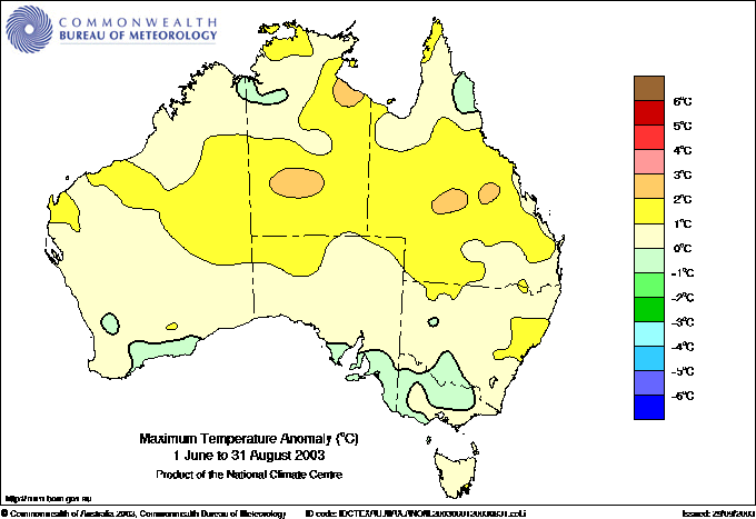
Observed maximum temperature anomalies for July to September 2003. Comments: No 1, real world NOT as overall warm as model. No 2, real world acrually has a warm RIDGE EW thru centre while model had a TROUGH. Some points for general Qld warmth but missed Cape York, Pilbara and and the cooler coast from west to Vic. SW WA NOT hot, again !! Cool anomalies in south exact opposite of prediction.
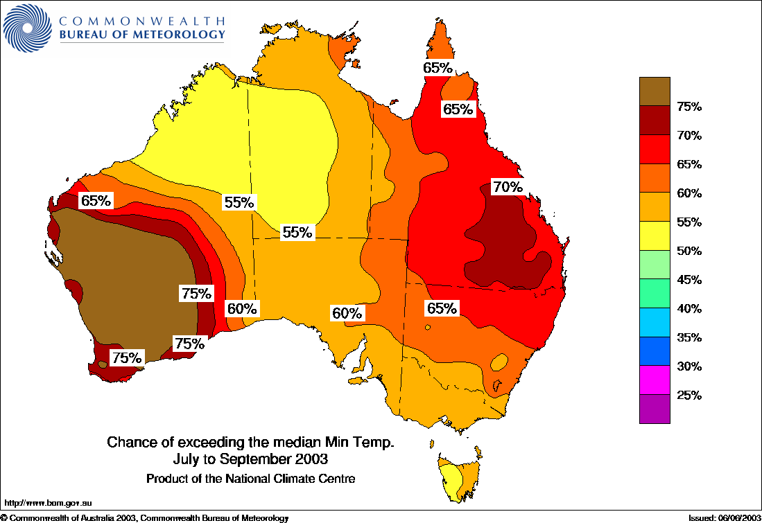
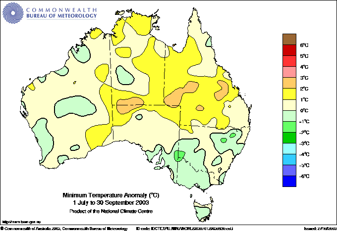
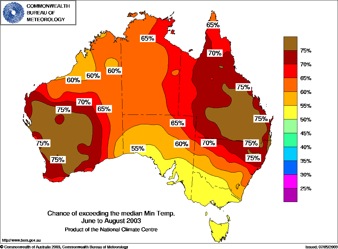
Minimum temperature Outlook Map for July to September 2003 published by BoM 17 June 2003. Comments;Model on steroids, again ! overall warmth predicted.
Observed minimum temperature anomalies
for July to September
2003. Comments:
No 1, real world is much closer to average overall.
Some marks for Qld warmth . S WA NOT hot again !! S
SA , Vic, NSW all cooler than model, Tas wrong again.
Maximum temperature Outlook Map for June to August 2003 published by BoM 15 May 2003 Comments; Number 1, too damn warm overall. Why can not these guys see this overestimating ???? Time after time after time.
Observed maximum temperature anomalies for June to August 2003. Comments: The top end might score 55% but the rest not worth two bob. South WA not hot again !! Southern cooler fringe not picked in model.
Minimum temperature Outlook Map for June to August 2003 published by BoM 15 May 2003 Comments;Once again, model on steroids, major overall warmth predicted. The model likes these dipoles.
Observed minimum temperature anomalies for June to August 2003. Comments: Let's score Qld a 75%. Southern WA not HOT againshould be a minus 35%, the BoM would claim Tas, Vic & S SA a success and the rest not worth mentioning it is so wrong.
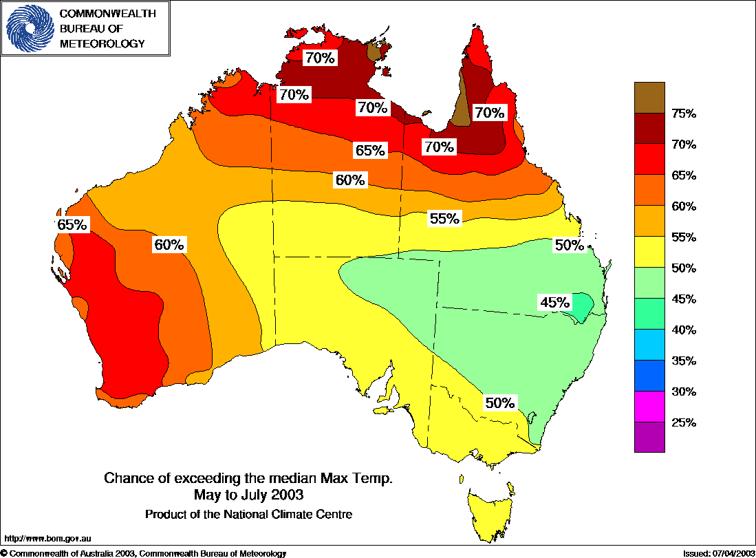
Maximum temperature Outlook Map for May to July 2003 published by BoM 15 April 2003 Comments; The model likes these easterley plunging troughs.
Observed maximum temperature anomalies for May to July 2003. Comments: How wrong can the BoM modelling be !!! But Hey ! they got Tasmania.

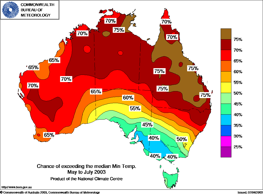
Minimum temperature Outlook Map for May to July 2003 published by BoM 15 April 2003 Comments;Once again, strong NS gradient in east.
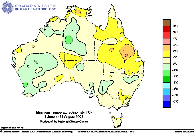
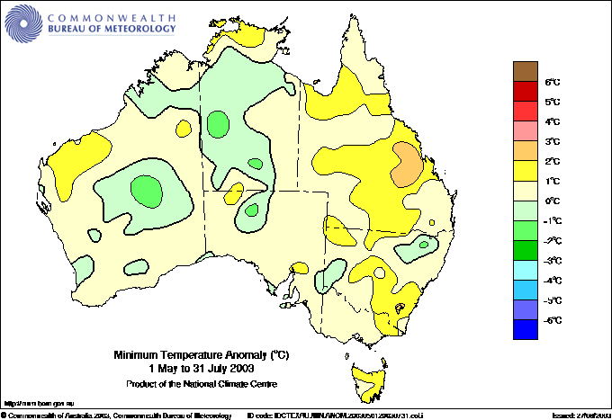
Observed minimum temperature anomalies for May to July 2003. Comments: Just not good at all and Ta......
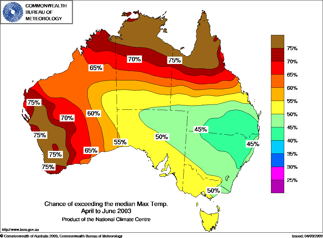
Maximum temperature Outlook Map for April to June 2003 published by BoM 18 March 2003. Comments; Plunging geosynclinal structure.
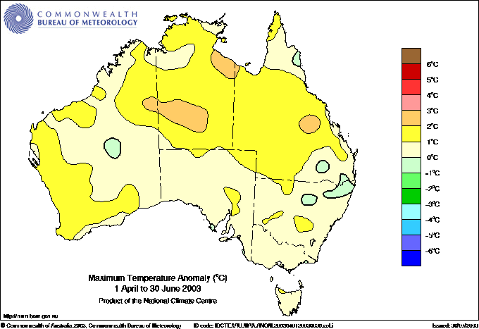
Observed maximum temperature anomalies for April to June 2003. Comments: About a 55%.
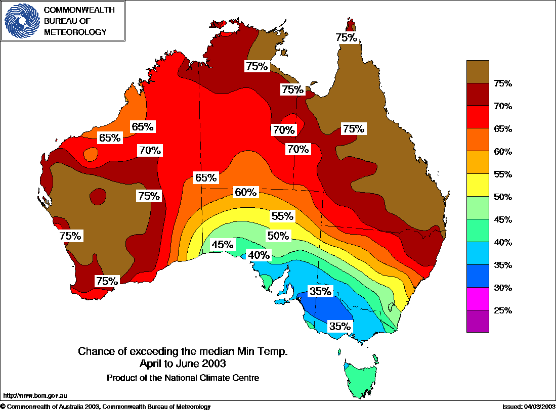
Minimum temperature Outlook Map for April to June 2003 published by BoM 18 March 2003. Comments;Model on steroids too hot, trough structure planges SSE.
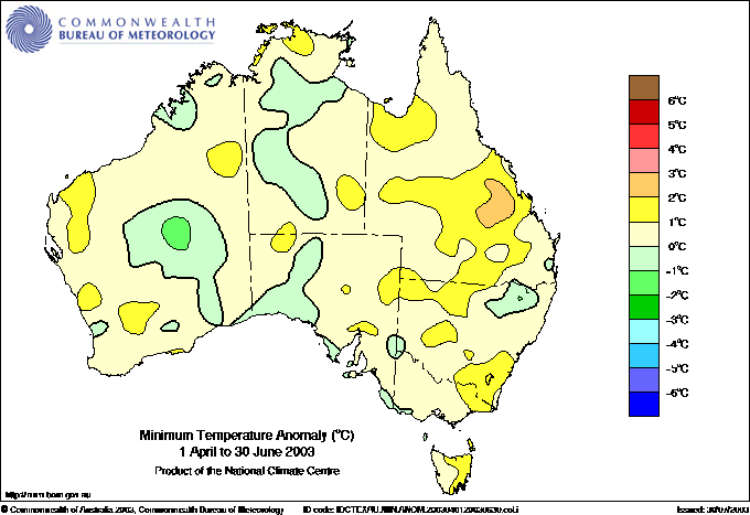
Observed minimum temperature anomalies for April to June 2003. Comments: Maybe some score for SE Qld but I do not see how the rest can rate. No sign of Vic SA predict cool. Tasmania wrong again.
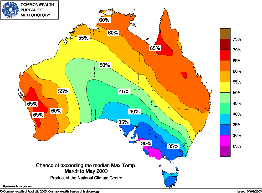
Maximum temperature Outlook Map for March to May 2003 published by BoM 18 February 2003 Comments; Synclinal structure, speaking geologically.
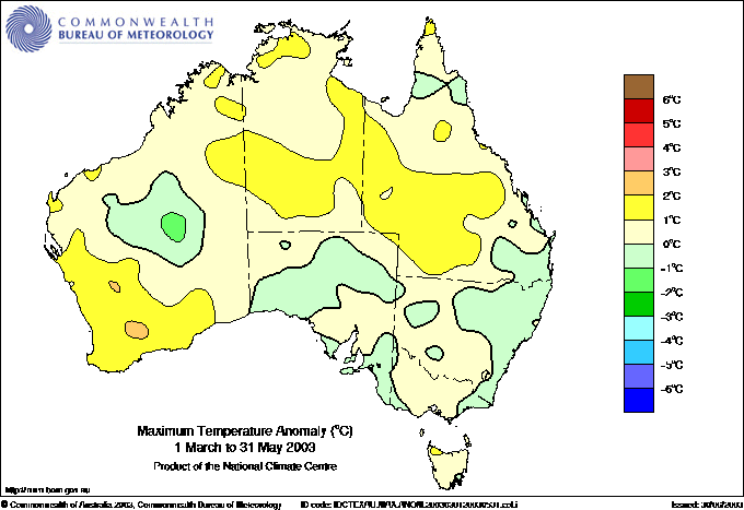
Observed maximum temperature anomalies for March to May 2003. Comments: Fair result, about a 65%.
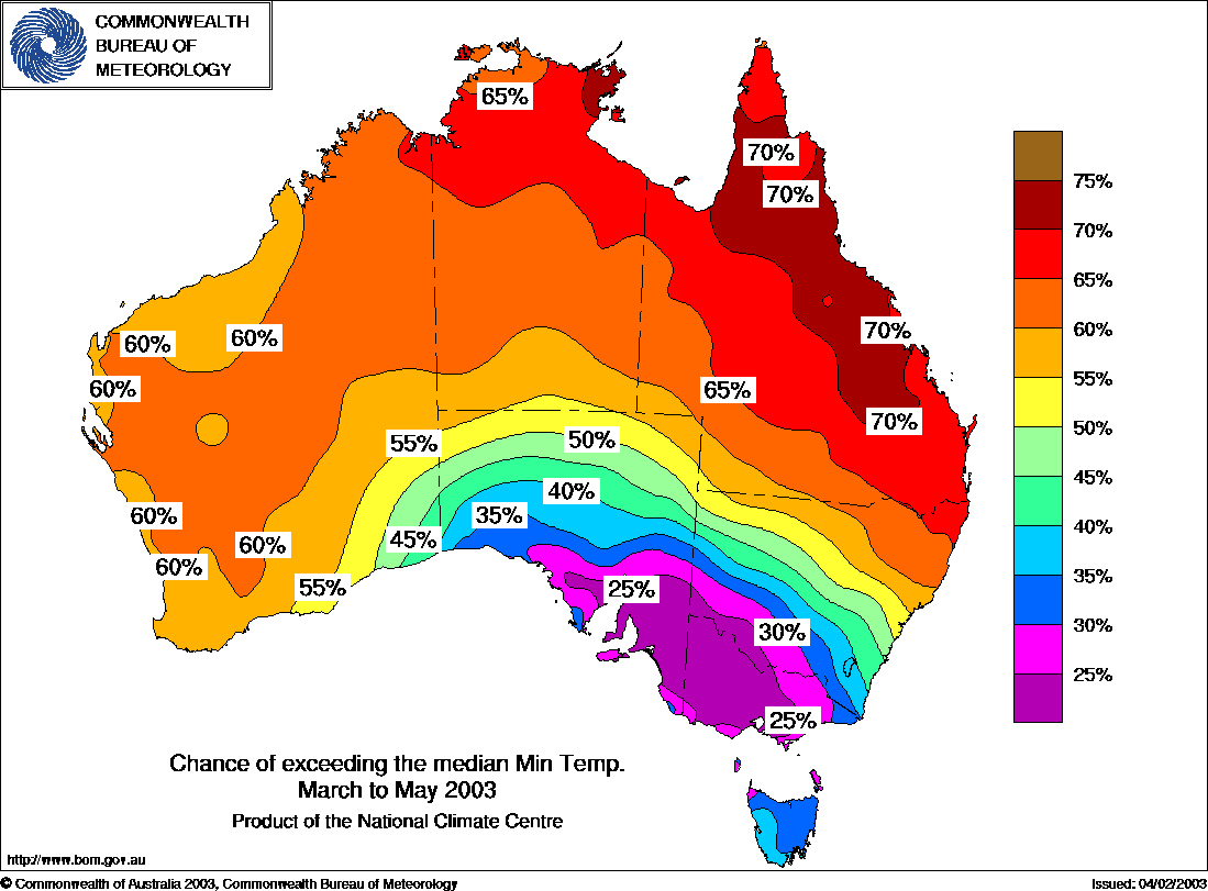
Minimum temperature Outlook Map for March to May 2003 published by BoM 18 February 2003 Comments; V well defined NS gradient in east
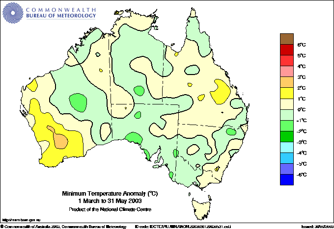
Observed minimum temperature anomalies for March to May 2003. Comments: Apart from S WA is there any more than say 25% merit ?.