Brisbane
water issues and catchment rainfall history 1900 to 2005
People are saying that Brisbane is experiencing its worst drought in
100 years.
Let’s take a look at what the data can tell us.
The Bureau of Meteorology (BoM) has a website with pages where you can
construct maps of drought affected areas for various periods. Readers
must realise that the BoM drought definition is a statistical one,
based on how current rain periods relate to the worst 10% of historical
data and the worst 5%. All this is explained on the BoM
website.
http://www.bom.gov.au/cgi-bin/climate/rainmaps.cgi
 Making a 3 year drought map of the Brisbane River
catchments for the period 1 August 2003 to 31 July 2006 (see below) we
see that no areas are classified as “Lowest on Record”. In
the portion of the BoM at left, pink is a "serious" rainfall deficiency
and the light red is "severe".
Making a 3 year drought map of the Brisbane River
catchments for the period 1 August 2003 to 31 July 2006 (see below) we
see that no areas are classified as “Lowest on Record”. In
the portion of the BoM at left, pink is a "serious" rainfall deficiency
and the light red is "severe".
So we must ask, exactly what are public figures talking about
when they say Brisbane is experiencing the worst drought in 100 years
? It could be that they are referring to another period.
Looking at rainfall historic data now and averaging annual readings
from Blackbutt, Esk and Kilcoy Post Offices we find that several
periods over 30 years have delivered similar rain to recent
levels.
Rainfall data is less than perfect, many stations close and
an alternative has to be opened at another site, recording can start
then stop, there can be gaps in data and on balance it would seem that
to make claims about the “worst drought in 100 years” could be beyond
what all the data could speak and looks like an attempt
to divert attention from past water policy shortcomings.
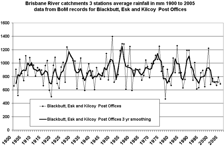
Starting in the years 1977 to 1980, again in 1986-87 and also in
1993-94, low rainfall years should have warned policymakers about
the limitations of the supply system. These clear signals of
cyclic low rain years, similar to periods such as 1918-19, are
set against a background of ever increasing population and
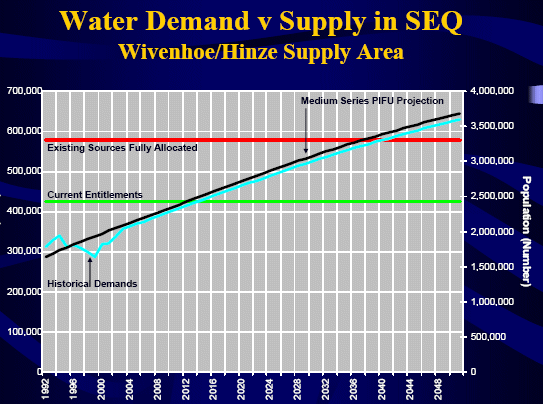
demand. The graph below is from a Queensland Govt report.
 At this point the issue of any changes to catchment
yields should be
understood.
At this point the issue of any changes to catchment
yields should be
understood.
Catchment yield is the perecentage of rain that makes its way into dams
and is reduced by a greater density of vegetation. It will be
interesting if we can discover if yields have been altered due to
changing vegetation, say
over the last 20 years ?
We are trying to discover data on catchment yields.
It is interesting to ponder that for every 100 mm of rain that falls
over the ~7000 sq kms catchment above the Wivenhoe Dam, about 700 Giga
Litres (GL = a Billion litres) falls onto catchments which is
about 60% of the capacity of Wivenhoe Dam. Of course only a small
percentage of this reaches the dam and this is the all important
yield.
It would seem obvious from the rain history data that policymakers
should have moved in the mid-1990's to shore up supplies.
Surely Brisbane people expect their Government to get water policy
right this time.
Dams have served Brisbane well for many decades, however it must be
recognised that due to the location of the State border and the
proliferation of National Parks, the most productive water supply
catchments in the Great Dividing Range have not been utilised.
Just as past signals about limitations to rainfall were not heeded by
policymakers when planned dams were cancelled, it would be bad
news for Queensland taxpayers if their Government lurched too far the
other way into undue pessimism about rainfall. No doubt Government
people are pressured by CSIRO reports based on pessimistic
greenhouse climate models predicting a drier future not to
mention the sales talk from desalination industry salesfolks who must
be pinching themselves that the Govt. is buying their water factories
yet rainfall is way over a metre per year in ranges scarcely 100 km
inland.
There can be no doubt that water costs will multiply with any move away
from traditional supplies and there will be a new water order with
upwardly mobile prices linked to energy costs plus the risk of strikes
in the desal water factories and the certainty of an increased water
bureaucracy feeding off the higher charges.
It is fascinating that Toowoomba recently voted on the issue of
drinking treated sewerage, yet not far from there rivers rise which
flow to Cubbie Station which has had no trouble in trapping truly vast
volumes of water.
One day in the future a Brisbane politician might discover that rain
actually falls free from the sky and can be trapped in dams for later
use.
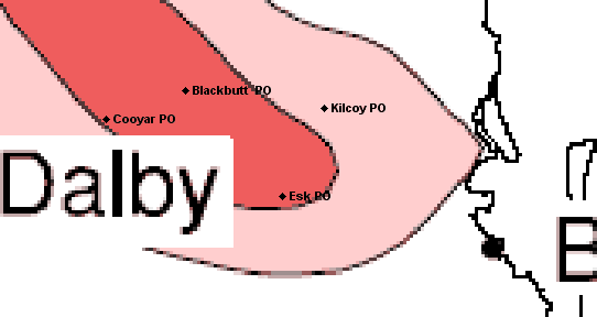
A note on data. Of course all the rainfall data used in the
graphic was bought from the BoM and the reference to Cooyar P.O.
on the map is because Blackbutt data was missing several years through
WWI and into the 1920's and I substituted Cooyar readings adjusted for
the typical average station difference. Kilcoy also
had 3 missing months in late 2003 which I replaced with estimates from
neighbours.
I think there are still gaps here and there in the daily data and if I
can obtain a more complete catchment dataset I might spend a long
day trying to correct these.
Back to Blog
Back to front page http://www.warwickhughes.com/
Posted 21 August 2006