A contact point for people interested in reversing the
tide of encroaching salinity in Western Australia. The various reports
that can be accessed here have been developed over recent years by
Peter Coyne, David Williamson, Jon F. Thomas and others.
The first 10 pages of "Dryland salinity in crisis - causes and
cures compared" by David Williamson
The causes and extent of dryland salinisation of
agricultural soils and water resources in Australia have been well
established scientifically and generally understood by rural land
managers.
The fundamental impacts of converting forest, woodland and heath
to arable agriculture include:
• rooting depth of vegetation changed from deep (>2 m)
to shallow (<2 m)
• a reduced availability of profile storage capacity for
infiltrating water;
• increased rate of aquifer recharge beneath the
agriculturally developed part of the landscape;
• an increase in the quantity, duration and velocity
of surface runoff;
• the change in the quantity and seasonality of actual
evaporation, and its spatial distribution within the landscape;
and
• the degradation of the soil resource in its various forms
- soil compaction, soil structural decline, soil acidity, soil
salinity, waterlogging, wind and water erosion, nutrient
deficiency, and decline in soil biota.
Managing salinisation of the land resources involves managing all
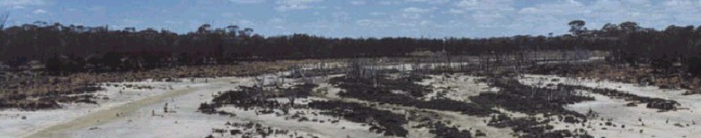
these impacts. Soil salinisation is probably the most visible of
the various forms of soil degradation.
The indicators of the process of land salinisation develop
immediately following the land use change and progress through:
1. development of an aquifer shown by the elevation of the
water level (hydraulic head) in an existing deep and generally
saline aquifer, or the creation of a new aquifer;
2. an increase in the mass of salt discharged from the catchment
measured as an increasing output/input ratio (O/I) for salt in
streamflow ;
3. the presence of areas of saline seepage (groundwater
discharge) and saline soil; and
4. poor growth and death of vegetation due to both excess water
and increasing salt concentration in the soil.
Unfortunately, there may be 15 to 50 years between stage 1
and the impact of salinisation on production at stage 4. Application
of control measures do not need to wait till stage 3 and 4
appear.
The desire to control the development of areas of saline soils
reached a critical state in the 1980’s with the emergence of
community and catchment land care groups. Despite the actions
taken over the ensuing 20 years, the current level of saline
groundwater discharge and the continuing spread of salinised land
remain as major concerns for farmers and water resource managers.
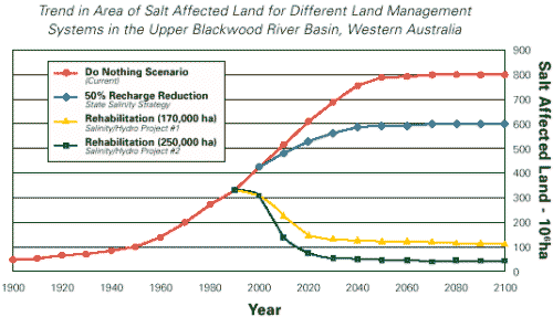
The extent of saline land is shown in Table 1 including the
prediction of the potential area at hydrological equilibrium.
The trend of increasing salinity in rivers is a significant and
direct consequence of the continuing salinisation process
occurring in both dryland and irrigated agricultural systems. The major
examples are seen in the declining water quality trends in the
Murray-Darling Basin and the loss of over 50% of the divertible
surface water resources in the south-west of Australia. The
increase in stream salinity for a selection of catchments is
given in Table 2.
Salinisation has its causes within the whole landscape
consequently the focus for management needs to be at the catchment
scale. Despite a recognition since the early 1980’s that managing
salinisation required an integrated catchment management (ICM)
approach, there has been almost exclusive focus on trees as the
solution to the problem. For at least
20 years there has been a persistent message giving to land
managers, landcare groups, politicians, the community and funding
bodies by
well intentioned individuals, groups and national organisations
that
"trees are the solution to the salinity problem". The large
investment
in planting trees, mostly to stop groundwater discharge in or
adjacent to saline areas, has had minimal effect for basic
technological reasons. Where plantings have survived, the impact has
been simply to hide
the unacceptable appearance of saline areas in valleys and
seepage
zones. Few land managers have claimed success with tree planting
programmes
in dealing with the salinity problem.
This paper aims to show that salinisation control requires
recognition of the range of factors operating at the catchment
scale which need to be managed. The salinisation process involves a set
of complex interactions requiring the integration of all
components
of a pragmatic and economic management system at the catchment
scale
to control the movement of excess water and salt.
The salinisation process has its impact on agricultural
production, stream water quality and its use, the natural ecosystems of
streams and landscapes, public infrastructure (roads, bridges,
urban amenities), and private and community buildings in rural
urban areas and on
farms. The management of the problem has both potential on-farm
and off-farm benefits which need to be included in any
cost-benefit
analysis of management options. These analyses need to include a
suite of factors in addition to the value of the land and the
restored
agriculture production.
BASIC REQUIREMENTS OF SALINISATION
There are 3 basic requirements for salinisation of soil and
streamflow to occur:
1. a storage of salt in the soil. This mass of salt has a range
of 50 to 5000 tonne/ha for a rainfall of 1400 to 320 mm
respectively.
2. a supply of water to mobilise the salt. The leakage to
groundwater recharge beneath agricultural crops and pastures
ranges from 4
to 10% of rainfall.
3. a mechanism by which the salt is re-distributed to locations
in the landscape, including rivers, where it can cause damage.
The hydrogeology of the regolith provides the structures for
transmission of water from recharge area to discharge area, including
the presences of geological structures which modify the direction
of flow.
Rehabilitation necessitates that only one of these 3 requirements be
eliminated, though where management is able to only partially
control one requirement, then achievement of the remaining
control must be found within another one of the requirements. The
removal of the stored salt would take 100’s to 1000’s of years
even at the current enhanced rates. There is no practical reality in
removing the store of salt. Rather there is significance in
avoiding the creation of conditions which could mobilise known
concentrations of salt in the regolith. Of the other 2
requirements, the logical approach for long-term control is to
cut off the supply of water (preventing excess groundwater
recharge) since this would manage the cause of the problem. The
recharge control focuses on the appropriate manipulation of
vegetation type, its
distribution and rooting depth. Since the hydrogeology of a
catchment
identifies the mechanism for water to move in the groundwater
system,
tapping into the hydrogeological structures, for example, with
artificial drainage, aims to intercept the process of salt
redistribution. Both of these approaches are discussed in more detail
in this paper. Rehabilitation could be expected to include the
application of a variety of both biological and engineering
options within a social and economic framework.
HISTORIC MANAGEMENT SCENARIOS
The classic approaches using vegetation have included:
• doing nothing! This has variations since farm management
practices are not static with specific changes determined normally
by
factors other than salinity control (eg. market forces)
• controlling excess recharge using perennial vegetation systems.
The recommendations have many variations including planting trees
on a percentage of the catchment, developing agroforestry
systems, inclusion of perennial pasture plants in crop rotation
systems, placing strips or blocks of trees upslope of areas of saline
discharge to intercept the groundwater flow, and planting trees
in high recharge areas.
• using "best management practice" (BMP) for agricultural
activities. This includes the vegetative control of excess
recharge especially applying agroforestry systems such as alley
farming, and whole farm water management systems.
• controlling seepage in discharge areas using shallow and deep
drains to remove excess surface and near surface water. Planting
of salt tolerant trees and use of salty tolerant pastures for
grazing has been applied in saline land across southern
Australia.
Revegetation with trees and perennial plants
Seeking recharge control Biological methods have been the primary
focus of management strategies since the 1960’s. Although few
perennial plants have been used, there has been reduction in
recharge measured for perennial pastures, specifically lucerne,
and also for tree plantations and other woody vegetation (eg. oil
mallee). Unfortunately there
have been many modelling studies of perennial vegetation
distribution in which the calculations assume that trees have
unlimited access to water in aquifers in both space and time. This has
led to proposals for using bands or strips of trees in an
agroforestry system across the landscape to act as biological
drains intercepting groundwater flow toward discharge areas. Few
studies have been rigorous enough to determine how much of the
observed fall in the groundwater level is due to actual withdrawal
by vegetation of water from the aquifer, withdrawal from within
the capillary zone above, and/or what is the result of natural
drainage when recharge has been eliminated. Basically, trees and
other woody perennials reduce recharge only where they are
planted and to a distance of approximately 10 m beyond the edge
of the tree belt or plantation.
The objective of establishing recharge control by catchment
scale revegetation techniques is sound in principle since it
seeks to manage the cause of the salinity problem and recognises
that salinisation is basically a groundwater problem. The
difficulty lies in applying the principle and in the capability
of economically viable agricultural vegetation systems to mimic
the hydrology of the native vegetation.
There have been advocates who propose that putting trees back
onto a proportion (from 10% to 30%) of the cleared land in a
catchment is sufficient to control the excess recharge. This
concept was first put forward in 1976 but one of the essential
requirements, the phreatophytic capability of the trees, has been
assumed but never demonstrated for Eucalyptus sp. in general. The
known exception is the river red gum (E. camaldulensis), and then
only where the groundwater salinity
is not excessive. There are good examples of catchments in which
30% (Upper Kent Catchment, WA) and greater (75% for Bingham River
Catchment, WA) of the area retains remnant vegetation but this
has
not prevented salinisation of soils and water resources. The
excess
recharge in the area of agricultural activity is not accessible
to
trees located elsewhere in the catchment.
Using the approach of planting trees in the areas of high
recharge under agriculture has been attractive. However, an
example of the inadequacy of this simple approach is shown in Figure 1
for a 100 ha catchment with 10 ha of saline land within which an
estimated 2,400
m3/year (240 mm/year) is being discharged from the aquifer. If
the
high recharge area of 10 ha (10% of the catchment) has excess
recharge
of 120 mm/year, re-forestation of the area would eliminate this
1,200 m 3 of water otherwise received by the aquifer preventing
its
flow to the discharge area. If the remainder of the catchment (80
ha) has an average excess recharge of only 15 mm/year, this is
equivalent
to adding 1,200 m 3 of water to the aquifer which will flow to
the
saline discharge area. Consequently, the 10 ha of re-forestation will
only
manage half of the water causing the area of saline discharge.
There has been a persistent message given to land managers
by well intentioned individuals, groups and national
organisations that "trees are the solution to the salinity
problem". Consequently, there has been a large investment in planting
trees usually within the saline and adjacent areas for the
purpose of using the excess water where it would otherwise
discharge at the soil surface. Where these plantings have
survived, the impact has been simply to hide the unacceptable
appearance of saline areas in valleys and seepage zones. Few land
managers have claimed success with tree planting programmes in
dealing with the salinity problem, at best, finding some control
in the area and/or rate of expansion of saline areas, or
achieving an aesthetic benefit.
Evaluation of success with recharge control
The scientific examination of revegetation strategies over the
last decade has concluded that the full management of excess recharge
at the catchment scale could only be guaranteed through
replacement of 70 to 90% of the original type of vegetation to
the landscape. This is obviously not a socially or economically
acceptable proposition.
Basically, the established agricultural systems all "leak"
and, therefore, only a partial control of excess recharge could
be expected for the current, economically-acceptable,
agricultural
vegetation strategies. The anticipation in the 1970’s of managing
salinisation solely through biological control of excess recharge
has not been realised, requiring more recognition that
complementary control measures will be needed to achieve even the
cessation of the continuing expansion of saline areas. While
there is excess leakage of water from the root zone
at the catchment scale, even using "best management practice",
water
will flow with minimum loss to discharge at the soil surface in
the
natural drainage lines of the catchment (often flat valleys) and
upslope
of hydrogeological barriers. The result is waterlogging and salt
accumulation, with some of the discharge becoming baseflow to a
stream.
Response time for recharge control
Even if adequate vegetation was established to reduce the
recharge to aquifers to pre-clearing quantities, there would be a
lag time between getting the vegetation in place and the cessation of
seepage to saline areas. Re-afforestation would require 4 to 7
years before full transpiration potential was achieved. The
subsequent decay curve for natural drainage of accumulated
groundwater is exponential, and includes a length factor for the
distance between recharge and discharge areas. It
is known that salinisation takes of order 15 to 50 years to
develop
after clearing. This time period should be seen as the most
optimistic
estimate of the time for the impact of an instantaneous, whole of
catchment re-forestation system to show an effect on seepage. A
natural
drainage analysis would show a much longer time for the
exponential
decrease in seepage to an acceptable rate.
Neglected issues in salinity management
A number of issues have been neglected in the pursuit of the
biological solution. 1. Development of engineering solutions involving artificial
drainage systems.
Managing the mechanism which mobilises salt in catchments is the
second basic requirement for the control of salinisation. For
over 40 years there has been resistance to exploring opportunities to
use artificial drainage because of the cost and the problem of
effluent
disposal. If these are the two principal factors delaying
progress
toward adding drainage to the options for controlling
salinisation,
then these factors require a concerted effort in research and
development, in innovative solutions and a redefined focus to
achieve effective results. Limitations in the understanding of
the hydrogeology in
agricultural landscapes, particularly the sedimentary
stratigraphy
often found in salinised broad flat valleys and the presence of
transmissive aquifers in non-sedimentary systems, has constrained the
possible
application of drainage methods in reducing the hydraulic head in
saline
land. Removing the hydraulic head causing groundwater discharge
(to
>2 m below soil surface) is acknowledged as managing the
effect
and not the cause, but has implications for the short-term need
to
prevent further spread of salinisation. However, in the situation
where the available management of the cause is either ineffective
or can only be identified as a partial long-term solution,
managing the groundwater discharge will be essential in both the
short and long-term. 2. Reducing the consequences of all forms of soil degradation
at the catchment scale that limit root growth and plant
production.
Determining the area of land affected by any one of the
sub-surface soil degradation problems has not received anywhere
near the effort given to determining the area of visual saline
land. These soil
degradation issues include soil compaction, soil structural
decline,
soil acidity, waterlogging, erosion, nutrient deficiency, and
decline
in soil biota. By virtue of their individual or combined impact on
rooting
depth alone, these issues affect water use and plant production
and
must be acknowledged as contributing to excess recharge, and
hence
the salinisation process. Most farmers have recognised wind
velocity
as a significant problem which affects plant growth and crop
yield.
Waterlogging is extensive in duplex soils. It is not confined to
flat valley sites but known to occur in all landscape positions.
The hydrograph data for waterlogged soils shows that the
direction for flow of the major volume of accumulated water is
vertically
downward. For broad-acre agriculture waterlogging may be the principal
mechanism for excess recharge. With soil compaction, soil
structure
decline and soil acidity, root depth would be restricted,
contributing
to a reduced availability of profile storage capacity for
infiltrating
water, and excess recharge.
Managing these soil degradation problems must be recognised as having
high significance in managing excess groundwater recharge at the
whole catchment scale. Application of what is already known in
the management of these problems must be seen as having a wider
implication than simply managing the individual degradation
problem. 3. Economic capacity and equity factors to support landcare
activities.
Currently, most farmers do not have the economic capacity at the
current commodity prices to undertake landcare activities at anywhere
near the scale required. Factors such as tax incentives, local
government rate relief for land declared non-productive,
realistic subsidies for landcare developments, as negotiation of
trade agreements which achieve acceptable commodity prices.
There is more recognition required of the equity issues which are
involved with landcare. All the factors which help determine the
private and public benefits which any landcare activity promotes
require both identification and quantification. For example,
there is a significant public benefit in the recharge
minimisation by land managers high in the catchment in addition to
the private benefit of
improved production. Even though a farmer may never have
salinised land, his actions to assist the management of excess recharge
in the catchment deserve a financial subsidy for their public
benefit.
Assistance in making provision for landcare activities may
be enhanced by the incentive of carbon credits which could be
specifically allocated to farm managers in their application of
agro-forestry systems such as alley farming, oil mallee
production etc. 4. Community responsibility to assist resource management.
The development of agriculture by extensive clearing of land in
the last 50+ years was promoted by government because of the
benefits to be received by the whole community in economic,
social
and political terms. The salinity problem is a legacy of the
development
of the agricultural economy and should be accepted as the
responsibility of the whole community. The salinisation of land and
water resources has its source at the catchment scale. The land
manager who owns the saline land rarely has the management
control over the remainder of the catchment in which his property
exists. On behalf of the community, government has a
responsibility to provide the economic, social and political
support needed to manage salinisation as was provided in loans
and tax incentives for the original land development. In some
management activities,
government could be the appropriate provider of the necessary
infra-structure. Benefits to the whole community, such as
improved water quality in rivers and streams, have to be included
in cost:benefit analyses.
5. Need to re-invent agriculture within the Australian
landscape, soils and climate.
Successful management of salinisation will include the urgent
need to re-invent agricultural landscapes to suit Australian
landscapes, soils and climate. Included in the suite of practices
will need
to be the strategic use and sound management of productive
vegetation on non-saline and saline soils. Permanent woody vegetation
will be included for its ability to limit recharge where it is
located, to provide shelter for stock and downwind vegetation,
and for aesthetic value and restoration of habitat for fauna
which control pests. New agricultural practices, and new crops
and pastures, need to be developed and applied
to eliminate causes of land degradation problems. 6. Market requirements based on accreditation to environmental
standards.
The future acceptability of our farm products on world markets
will be gauged by audits measured against environment management
standards including the judgement of the adverse impacts, such as
salinity, and sustainability of agricultural management practices.
Environmental management systems which will require compliance
with standards such as ISO14001 are being developed to provide
guidance to land managers in modifying practices.