This morning the news is all abuzz with the bushfire threat to townships just SE of Glenmaggie in Gippsland, Victoria.
Cowwarr, Dawson, Glenmaggie, Heyfield, Seaton, Toongabbie all have warnings issued. Weather radar shows the fire ignited west of Mount Useful about 1pm yesterday 17 Jan and moved SSE steadily to where it is now breaking out of bush into inhabited areas. Use the slider to control the image – local time is in bottom left where it says “(Updated on Server)”
I would like to know what was done to fight this fire yesterday ?
And where are multi-engined fixed wing air tankers when you need one ? Answer – sitting idle in the USA.
Just another shambles.
The radar images are great but was anybody watching yesterday?
I get an impression over a few weeks watching news of your fires SE of Hobart, east of Cooma, West of Yass, Deans Gap Nowra and now Coonabarabran; that the brigades just seem to battle away travelling with the fires over many days or weeks. Often not putting them out, leaving them ready to flare and run with the next wind.
Watching all this; and now today the Aberfeldie fire being left to gather strength all yesterday afternoon and evening, I think multi-engined large air tankers should be persevered with. Sooner or later a small town of thousands of people will be in line to be wiped out. Just waiting for the wrong circumstances. I think they were very lucky with Yass that the wind dropped on the 8th. We are lucky to be getting only mid-20’s out west today.
Once I calculated that Victoria’s controlled burn plans would take 192 years to cover the whole State at the planned rate. Maybe now they let fires burn in lieu of doing controlled burnoffs at other times, with skill and prudence of course.
Warwick, it’s 7 pm on Frid 18 Jan. Your email in tray seems overloaded. Can you please try to contact Chris to clear an article waiting publication? Tks Geoff.
Just a quick comment on Sydney’s hottest temp yesterday. The temp reached 45.8C at 2.55 pm.
I captured the AWS at Sydney Observatory and note the following.
14:39 – 44.3C
14:49 – 44.9C
14:59 – 44.7C
15:00 – 44.7C
The temp must have risen 0.9C in 6 mins and then dropped 1.1C in the next
4 mins. Would that suggest a hot gust of wind at that particular time?
I know this is OT to your subject at hand but needed to post
quickly before the AWS record disappears.
Ian George, you need a screen capture program. For Windows XP/NT there was/is a good free program PrintKey 2000 5.1 from Fred’s Software. Unfortunately I have not found a good (free) one for Windows 7. Maybe someone can help.
Your observations need to be published widely but you need proof.
Your point about gusts of wind is worth noting. A proper Stevenson screen would eliminate short (minute by minute) fluctuations. The max & min temperatures then have some relevance. But if the recorded max or min is now an instantaneous reading in a very small enclosure as shown by some of the photos on WUWT of new instruments then recent measurements will not be comparable to older measurements. Also, a mercury glass thermometer has some heat capacity (ie takes time to research equilibrium). A thermocouple (with little sheathing) can have raid response. Warwick may like to comment.
I have taken the temp from weather.ninemsn and these are backed up by the BOM site (daily observations). I saw the 45.8C
on the BOM site but did not write down the time. However, the papers seem to have recorded around 3:00 pm. Winds at the time were 19/20kms an hour from the east.
I have a screen capture on my iPad and have it saved. The data I have saved is still at the locations I have mentioned above.
Ian George:
An airconditioner “cycling”, perchance? 😉
Dry air has a low specific heat. To reject heat into air at a decent rate (power), one has to move a lot of air and/or change the temperature of the air by a several (even tens) of ⁰C as it passes through the heat exchanger.
Ten grams more of water vapour per cubic metre of dry air makes the air a great deal more able to take up heat; without changing its temperature a great deal. The psychrometrics go beyond airconditioning systems in applicability. Everything from combustion engine management through to “climate” needs to keep in mind that a small change in water vapour content can make a big difference to heat content/capacity and therefore temperature.
A study of a (modified) Mollier diagram is all that is necessary to gain an appreciation of how a few grams(H2)/kg(dry air) can make a difference. Prerequisites are an understanding of enthalpy and entropy.
47.9C (I think, unreliable memory) is the top recording for Perth, early 1990s. I was out in it that day, crabbing in Mandurah estuary. It was hot and we didn’t do too well. In those days, ‘Straya used to have hot summers with high/acute fire danger. Now, climate has changed, and it’s all different. That’s progress I suppose.
Does anyone know anything about platinum wired electronic thermometers and how long they have been used in Australian weather stations? Apparently these can pick up changes in temp quite quickly and may explain the unusual change to temps over the ten minute period on Friday.
Hector
There was a 46.7C on 23rd February, 1991 recorded at Perth Airport – a little lower at the Regional Office.
Ian George:
Platinum wire thermometers respond quite quickly; certainly could cope with a 0.9C rise in 6 minutes. We used them in the laboratory for measuring exotherms of 130-160C in 10 -15 minutes. That was in immersion use which would have speeded the heat transfer rate.
They were a bit slower cooling down because “the works” come encased with a stainless steel sheath. Coming down with air cooling from, say, 150C was noticeably slower. Given your parameters I have doubts about them returning to 44.7C in 4 minutes in air, unless the Weather Bureau has non sheathed versions for very rapid response.
I use a cheap, digital indoor-outdoor thermometer to monitor the temperature inside my refrigerator, using the “outdoor” probe inside the box. I’ll check the temperature before I open the door, but by the time that I close it again, less than aminite later, the indicated temperature is several ⁰C higher; sometimes more than 10⁰C. In less than a minute. Obviously opening the door provides a substantial change of air to whic the sensor responds rapidly.
Then, often simply by losing heat to the solids and liquids stored in the refrigerator (because the compressor doesn’t kick in), the air temperature inside the refrigerator returns to “nominal” within 10 minutes, falling perhaps 10 degrees.
The sensors aren’t reading the “true” transient temperatures of the air (they have their own thermal inertia and the air has low heat capacity), but they respond substantially to a change within a short time. One needs to consider how (un)important the short, unmeasured peaks actually are in the bigger picture.
For the fridge, what is important is the temperature of the solids and liquids stored in the box. The air temperature inside the fridge is only significant as a long-term average. Thus; the transients can be ignored.
I just tried searching google
and have not found much yet but am busy right now.
My search terms were a bit clumsy – thermal inertia meteorological mercury thermometer compared thermocouple
Graeme & Bernd, I think we are getting there on response and sensitivity but need to confirm exactly what are BOM using at Observatory Hill.
My understanding is they are using resistance thermometers which normally are free expanding platinum wire in a sheath. The thickness will determine the instrument response which could be under a minute. These need to be powered so there is a limit to the distance from a power source (which could be inside a building ie heat island effect)
Thermocouples have quicker response -unsheathed Pt-PT/Rh have a good temperature range and voltage difference output, and can respond in fractions of a second. They are normally sheathed but this can be as small as 1.6mm in diameter for quick response.
I understand there are now peizoelectric ceramic resistance instruments. These are used in computers to monitor temperature. In small size hey have quick response.
Beside the response and sensitivity of the measuring instruments I have suggested above that the enclosure may also have an affect on the recording of maximum temperature. The Stevenson screen was quiet large and so less prone to small swings in temperature from wind gusts. It appears the enclosure of continuous temperature measuring instruments in the modern era (since say 1965) is very much smaller. One can not compare an instantaneous measurement over a few second with a measurement from an enclosure which may have an overall response of 10,15 or even 30 minutes.
Based on the quoted results by Ian George above if averaged over 15minutes the supposed record max. temp. would disappear.
I suppose my point is that a sensitive platinum wired ET would pick up a change in temp much more quickly than the older thermometers used in 1939. Thus we would not be comparing ‘apples with apples’. I still believe the quick increase followed by a quick decline (all in ten mins) is highly remarkable.
The AWS monitor graph does not show the temp going over 45C though the AWS record shows 45.1C at 14:30.
Would the BOM have a copy of the minute by minute temps?
I think $94 is the minimum charge to buy a few kb of BoM data for us mug sucker taxpayers.
I must be careful of my language – the above little comment got trapped by the SpamCatcha.
A reader sent in this link to an animated map of global wildfires as seen from space. Australian forest fires are only minor in comparison to seasonal fires in equatorial Africa, Southern Africa, South America and many parts of Asia!
The other ‘global maps’ are also interesting………. carbon monoxide, water vapour etc etc
I recall seeing an earlier version of these data years ago.
PS: Please be patient if any comments are slow to appear – yesterday the site suddenly started getting hundreds of spam comments per day – can only hope the wave dies soon.
This thread has been discussing the OT subject re comparing readings in a modern AWS or thermistor with those read decades ago off a mercury thermometer and whether the AWS responds faster to warm air currents. An expert reader has sent in the following –
The move to AWS and the concurrent shift of many sites from Town Post Office to airports is like a fault line through the Australian climate records. In many cases the site change is not registered in the data because both have the same station number. This fault line is papered over by the analysis of the data using GIS procedures – any analysis is based on the stations reporting for that day/month and does not require a continuity of record at the site. Thus the ‘Australian’ daily maximum, and other BoM published analyses represents the available data interpolated to grid points and then areal averaging the gridpoints, not the data. For most practical purposes this is OK; the problems arise when trends or new records are claimed!
My first-hand experience of thermistors relates to an Darwin in the middle 1960s. The meteorological office had a remote reading and graphically recording thermistor in the instrument shelter to enable duty meteorologists to keep up with temperature changes at the airport. In winter there is a steady SE stable airflow across Darwin harbour to the then observing site and recorded winter minimum temperatures are fairly regular. However when the airflow turns more easterly it has a trajectory over the land rather than water. Although not registering on the minimum thermometer, the thermistor graph would often drop briefly and recover as the wind fluctuated. It should be noted that the thermistor was for operational use and the data did not get into the climate record but it did show the sensitivity not picked up in screen located thermographs and presumably not glass thermometers, each with a longer thermal lag.
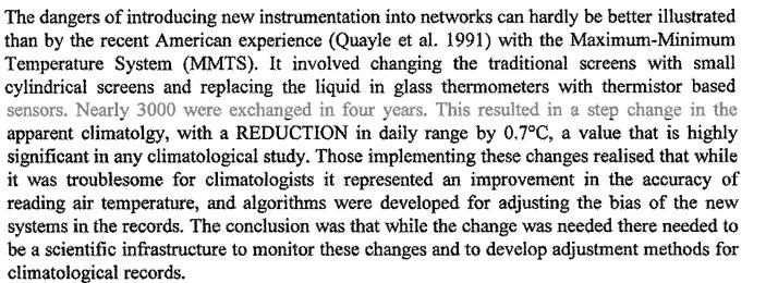
A WMO report puts the issue clearly:
Globally, how careful have the relevant authorities been in adjusting for the bias as meteorological services have shifted to AWS?
Immeasurable thanks for that expert information and the link to the WMO’s look at changes to enclosures.
FWIW; a standard “cheat” for achieving consistent readings from thermistors, which “work” by rejecting heat to their environs, is to use a small fan to blow a steady stream of air over them. One must be careful to ensure that the airflow is consistent but with the right controls, consistent, rapid response to air temperature is possible. Small eddies of air that do super-impose are much less significant within the overall fan-forced flow.
Devices are typically calibrated in still air so any forced convection, i.e. any air movement caused not solely by the sensor will cause the sensor to behave as though the air were cooler.
Some more from the WMO (PDF)
So the switch to AWS may be largely responsible for more extreme weather. 😉
I’ve seen mention of the step change downwards of the MMTS and seen the suggestion that it’s not so much that the sensor reads lower than the LIG thermometer, rather that lack of maintenance of the Stephenson screen allowed the whitewash to fade and darken, leading to a gradual increase in the temperature.
DaveE.