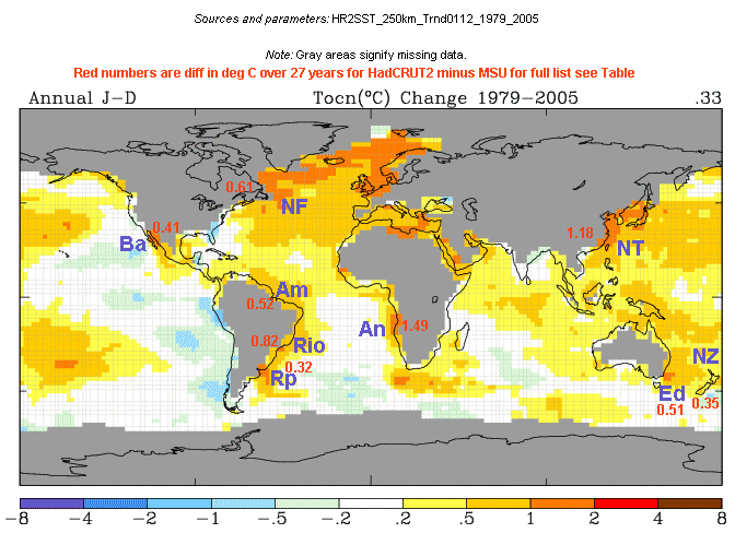
SST's warm patches mismatch with NASA UAH satellite trends 1979-2005

I made this map at the GISS website module, http://data.giss.nasa.gov/gistemp/maps/  and it shows the 27 year trends 1979-2005 for an SST (sea surface temperatures) dataset that GISS names HadReyn_v2 which I take in to mean the Hadley Centre version 2 SST's with Reynolds data grafted on post 1982.  There may be another explanation of exactly what the dataset is but for sure it is the SST data Jim Hansen's GISS group chooses to use.

I have annotated several warm anomalies near land that caught my eye and the Table below has exact Lat-Longs together with trends per year for UAH MSU LT vs HadCRUT2 combined land sea data taken off the calculation module at www.co2science.org plus the 27 year 1979-2005 difference in degrees C. 
NF refs to New Foundland, Ba = Baja, NT = North Taiwan, Am = Amazon, An=Angola, Rio=RDJ, RP=River Plate, Ed=Eden and NZ = New Zealand 10 degree grid cell.
Region
Lat
Long
MSU
HadCRUT2
SST-MSU 79-05 deg C
NF
45-50N
45-50W
0.035537
0.058120
0.61
NF
50-55N
45-50W 0.034914
0.04822
0.36
NF (incl land)
45-50N 50-55W
0.038062
0.033468
-0.12
Ba
25-30N
110-115W
0.014105
0.029212
0.41
NT
25-30N
120-125E
0.009356
0.053243
1.18
NT (west)
25-30N
125-130E
0.000983
0.029731
0.77
Am
0-5N
45-50W
0.005723
0.024945
0.52
An (incl land)
10-15S
10-15E
0.004546
0.059928
1.49
Rio
20-25S
35-40W
0.005339 0.0358
0.82
Rp
35-40S
50-55W
0.011944
0.023956
0.32
Rp east (incl land)
35-40S
55-60W
0.0101
-0.009
-0.03
Ed
35-40S
150-155E
0.004198
0.022979
0.51
NZ (area incl most NZ land)
35-45S
170-180E
0.010588
0.023471
0.35
Why are these SST warm spots "going to water" when compared to satellite lower troposphere trends ?
Is it unreasonable to expect greater agreement between lower troposphere satellite data and SST's ?
To keep dimensions in perspective,  at 35 degrees latitude a 5 degree grid cell is ~ 440 kms across EW, while the lower troposphere is say 8km high, so we are talking about satellites remote sensing a skin one fiftyfifth as high as the grid cell is wide.
Are some of  these anomalies due to SST's being adjusted to better match land trends ?
All for now  12 Aug 2006
Rio and NZ added 14th.
1979-2004 trends version of GISS SST's global map  added 24 Jan 2007