JULY 3rd 2006
URBAN HEAT ISLANDS
Those who claim that increases in carbon dioxide are harming the climate place greatest emphasis on the assertion that the "globe" is "warming".
It so happens that this claim is incapable of being supported from measurements made on or near the earth's surface, because it is impossible to place measuring instruments in sufficient numbers randomly over the earth's land and ocean surfaces to show that there is a significant upward trend in the average temperature.for a sufficient period of time
The only possibility has arisen quite recently with the use of NASA satellites which can monitor the entire earth's surface from the lower atmosphere. The technique uses Microwave Sounder Units which measure the microwave spectrum of oxygen in the atmosphere, from which temperature can be calculated.
As has been shown by my recent paper at
http://www.climatescience.org.nz/assets/20065312045370.TemperatureTrendsVGray.pdf
The satellites show that there has been no sign of a temperature rise in the lower atmosphere since 1979. Most of the record shows a zero slope, but there are. occasional temporary aberrations from volcanic eruptions and ocean oscillations
How, then, can they make the persistent claim that the "globe" is "warming" by as much as 0.6ºC since 1900?
The "surface record" which they try to promote as the only true record of global temperatures is actually a multiply averaged concoction of unrepresentative readings from weather stations and ships which is hopelessly biased upwards by urban effects and unchecked instrument and operational defects.
The globally averaged surface record system involves dividing the world into latitude/longitude boxes and choosing sets of temperature measurements from weather station or ship records.in each box The daily records (often from a single reading of a maximum/minimum device) are averaged, then the weekly records are averaged, then the monthly records are averaged, then the annual average is subtracted from the average of a selected annual range (currently 1960 to 1990) to give the ANOMALY for that month, or year. The anomalies are then averaged after an area weighting process (cosine of the middle latitude) to give a hemisphere or global mean anomaly.
Some people have recently alleged that the kind of map used to display the results is a fraud. It is no more fraudulent than the errors of the map used. It is surely generally recognised that a Mercator map, for example, gives a distorted picture of the world, so the temperature anomalies are similarly distorted.
The deficiencies of the exercise, however are fundamental. many of these have been described in my paper on
http://www.john-daly.com/cause/cause.htm
and in a more recent paper by Chris De Freitas at
http://www.climatechangeissues.com/files/science/defreitas.pdf
Some boxes may have only one measurement station. The average number of stations per box in Russia is two, We are expected to believe that these can be considered representative of several thousand square kilometers of variable territory. Very few stations are permanent. They come and go. The number of weather stations worldwide fell from 6000 to 3000 and the number of occupied boxes from 350 to 100 between 1970 and 2000. Sea measurements are even worse as they are rarely in the same location.twice.
Many long-term surface records from sites which have undergone little change show no evidence of warming.You can try this for yourself from Hansen's excellent website
http://data.giss.nasa.gov/gistemp/station_data/
where you can download records from any chosen part of the world
A recent paper by T.C. Peterson 2000 "Assessment of Urban Versus Rural In Situ Surface Temperatures in the Contiguous United States : No Difference Found". Journal of Climate Vol 16 pages 2051 to 2959 supplies much more information on the process and its snags than has appeared before. The IPCC has chosen to ignore previous studies on urban heating and the other problems by latching on to the "No Difference Found" statement in the title of this paper without appreciating that it probably applies only to the contiguous United States, or other territories with a similar density of weather stations and the expertise to carry out the necessary corrections.
Peterson begins with an excellent literature survey of the overwhelming evidence for an urban influence on weather station measurements. The usual technique is to compare records from "urban" and "rural" stations and much depends on how "rural" is defined. Population size below 10,000 is often used, but records may be outdated, so that the "rural" place may have recently expanded. There are several studies showing that even "rural" sites can be influenced by urban effects and Peterson fails to deal adequately with how you could tell that a "rural" station is free from "urban" influence. All he has to offer is the decision in this study (and other recent one) to define "rural" as "showing few lights at night". This method may be useful for the USA, but its use over many parts of the world is doubtful.
He studied only three years of data, 1989-91, so he was unable to study "trends" His excuse is rather startling. "A longer period would increase the problem of missing data". The problem of missing data is not otherwise mentioned. but if it is must be important if it has an influence after only three years in the USA. How important might it be elsewhere and where are the data?
He chose for study 40 clusters of stations, well distributed over the country; a total of 289 stations, 85 "rural", 191 "urban" and 13 "suburban.
It was surprising to learn that in the Unites States there ware several different types of instrument and shelter. There were 106.9 Maximum and minimum liquid-in-glass thermometers in a Cotton Region Shield (CRS, resembles a Stevenson Screen), 142.8 thermistor based instruments in a MMTS shield. . 35 hygrothermometers in an HO-83 housing and 2.3 hygrothermographs.(the fractions are from changes during the three years). There are photographs of these three types. If the Americans have several different instruments what kinds are used elsewhere?
Corrections had to be made for urban/rural location, Elevation, Time of Observation bias, instrumentation, and siting, all with great difficulty.
The claim in the title "No Difference found" is untrue. The overall urban/rural bias was +0.31ºC, half the amount claimed to be caused by greenhouse gases since 1900.
However, the other corrections whittled this away. so that when they were all applied it went down to +0.04ºC The Time of Observation bias accounted for -0.17ºC because rural stations had a higher proportion of morning readers. Differences in elevation accounted for -0.11ºC, because rural stations in the USA are usually higher up than the cities. Differences in instrumentation accounted for -0.05ºC, because rural stations had a higher proportion of hygrothermometers that had a warm bias over the period,, and latitude changes gave a negative bias, -0.06ºC. as urban stations tended to be a little further north than the rural stations.
The fully adjusted bias of +0.04ºC was regarded by Peterson as zero because it was not significant at the 90% level..
So we can say that fully adjusted US data give an accurate measure of temperature trends. As we all know, these trends do not indicate evidence of a consistent warming trend, so there is no evidence for the presence of the greenhouse effect for the contiguous United States.
But what about elsewhere? Very few places have the number of stations or the expertise of the USA for the complex correction process described here. The only other country that has attempted it is China, and as I keep pointing out, they also show no evidence of greenhouse warming.
In most other countries the complex correction procedures carried out by Peterson are impossible as they do not possess the numbers of sites for comparison, the supervision or the scientisific expertise. In these cases the first, unadjusted result of Peterson's, an urban/rural bias of +0.31 ºC could apply. The IPCC has no right to assume that what applies in the USA must apply everywhere else. The individual adjustment figures could also be very different elsewhere.
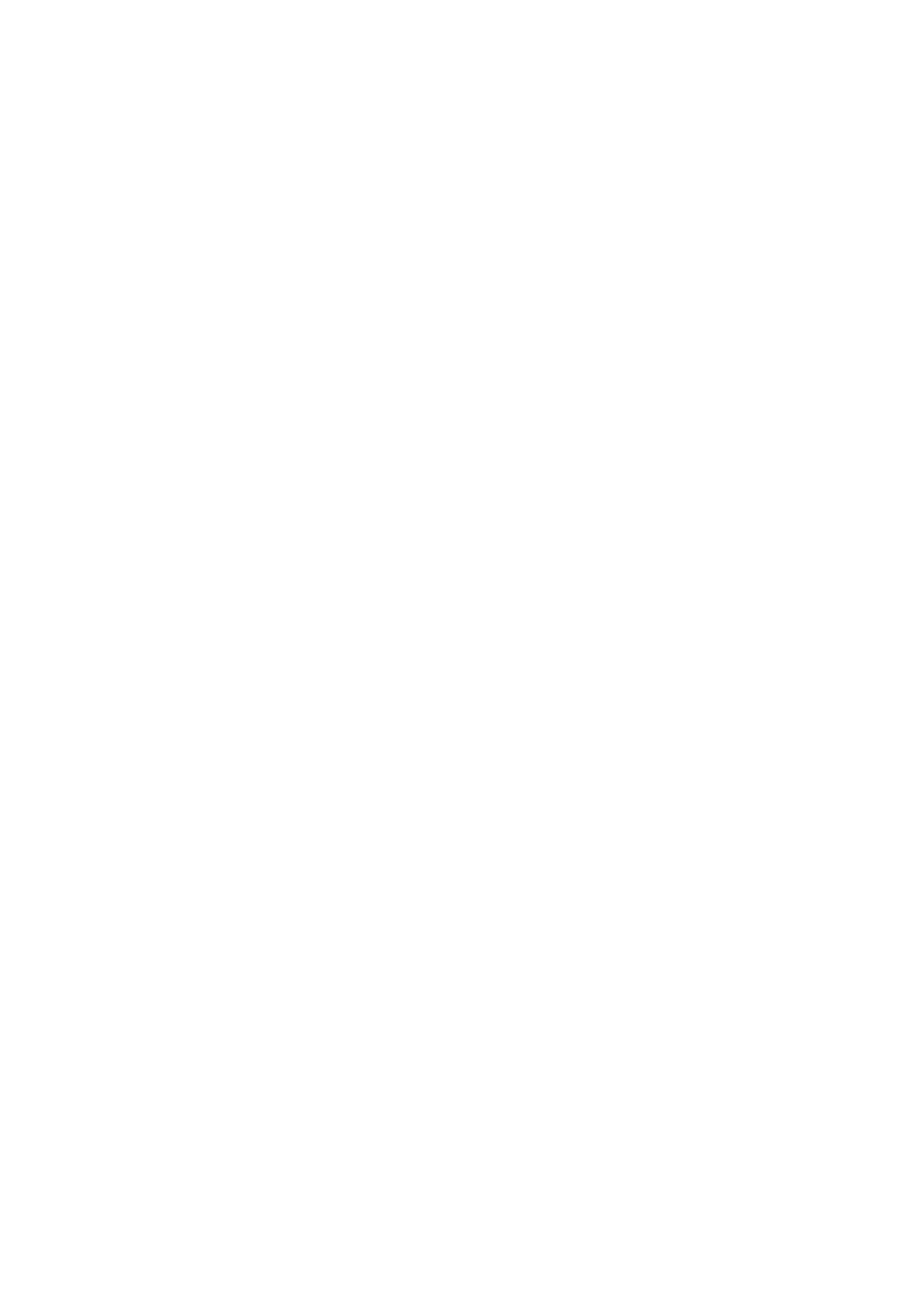
A recent paper by Jin et al. 2005 Journal of Climate, Volume 18, pages 1551 to 1565 used recent measurements with a MODIS spectrometer on NASA satellites to measure the urbanisation effect globally and over several selected cities. I attach their global graph for July 2001 for night time and daytime temperatures. It will be seen that urban areas between 30 and 60 degrees north are eight degrees Celsius above a surrounding forest, by day and two degrees above at night.These are much greater than the "corrections" that are made to the surface record.. They also studied differences between urban surfaces and cropland and for selected cities.
They make the following comment, which is relevant to the Peterson paper and to the IPCC approach
"Urban areas have generally been determined from satellite data from the night time lighting. Such a measure is more an index of electricity use than of urban features that are significant for climate study.
They propose an "urban index" which should be used instead, which incorporates skin temperature and albedo.as measured by their method.
In a recent paper, Folland et al Geophysical Research letters 2001, Vol 28 pages 2621 to 2624 use an array of statistical methods and correction procedures for the surface record..
Despite this effort, McKitrick and Michaels 2004 Climate Research Vol 26, pages 150-1`73 showed that the surface anomalies for 1979 to 2000 were significantly biased by rises in population, energy usage, sample defects and GDP. Removal of these effects reduced the average temperature trend from + 0.270ºC per decade to + 0.011ºC per decade.
The paper by Davis E Parker "Large- scale warming is not urban" 2004, Nature Vol 432 page 290 is also used by the IPCC to deny urban heating. It so lightweight that it does not fill even a single page. It compares changes minimum temperature records for "windy" and "calm" nights for 264 stations since 1950 and finds very little difference. Parker admits that coverage is only good north of 20º North plus Australia and that the timings of the minimum temperature readings were unknown, a factor which Peterson found to be very important
But, of course, windiness." is only one factor influencing local temperature. The radiation environment which changes with number and of surrounding buildings or increase in concrete roads. energy usage, the number of vehicles or aircraft all have effects which may not be much related to wind speeds.
Parker also gets it wrong when he says "Urban Heat Islands occur mainly at night, as Jin's paper (graph attached) shows.
The upwards bias in the
surface record compared with the temperature measurements of satellites
and radiosondes in the lower atmosphere, when these have been corrected
for El Niño events, will become more evident as time goes
by. It cannot be caused by increases in greenhouse gases, so it
must be due to urban effects which have not so far been satisfactorily
identified.
Cheers
Vincent
Gray
Crofton Downs
Phone/Fax 064 4 9735939
"It's not the things you don't know that fool you.
It's the things you do know that aint so"
Josh Billings