Urban Heat Islands (UHI) detected as Infra Red Signatures by GOES satellites.
Both can be accessed from the State University of Colorado web page, also from NASA and NOAA, where there many images to view and much useful information.
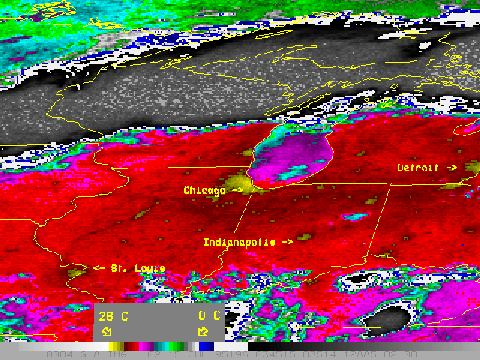
This image shows a cloud free window where the infra red radiation reveals UHI signatures over Chicago, Peoria, St Louis, Indianapolis, Fort Wayne, Detroit and many smaller towns and areas of lower level urbanization. There is a temperature scale at the bottom of the coloured image. The EW grey area north of Chicago is presumably cloud cover.
Text in blue direct from NOAA web page.
Imagery from the 3.9 um band of the GOES Imager makes it possible to locate urban heat "islands" under clear sky conditions, especially during the night-time hours. As discussed earlier, there is inherent variability in land-surface temperatures over distances of fractions of a kilometer, even more so around cities and their suburbs. The GOES FOV over cities may be thought of in the same sense as partially filled fields-of-view over fires. This results in higher radiance temperatures being measured at night over cities at 3.9 um than at 10.7 um.
In this example, the signatures of several Midwestern cities can be seen in an image from the early morning of 14 July 1995. The cities are darker (warmer) than their surroundings.
.
The following image is of the eastern
seaboard of the USA and SE Canada.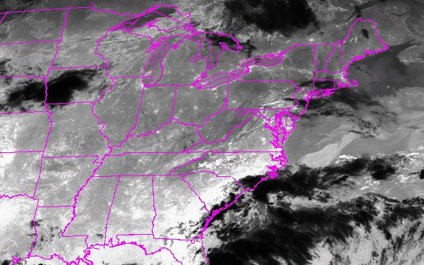
UHI signatures stand out as white points and small areas often
following highways such as in northern New York between Albany
and Buffalo. Dark areas may be cold cloud while broad areas of
warmer land surface such as the SE coast show up near white..
© Warwick Hughes, 2000
globalwarming-news.com
Back to Front Page