ABARES is the Australian Bureau of Agricultural and Resource Economics and Sciences – they are having their annual conference on 4 – 5 March.
The ABC has just posted this story – Drought takes its toll on the soil –
Featuring this map which compares the upper layer soil moisture from January 2014 with readings for the past 100 years.

Why not update the map following good rains in February in western Queensland and parts of New South Wales. Surely with the combined talents of ABARES – CSIRO – BoM they could have done that.

Would have changed their entire story – making the map compare late Feb 2014 soil moisture to the past 100 years would have resulted in smaller areas of scary brown patches.
Just think of the combined salaries.
Now I can see where that scary white area in the Great Sandy Desert rainfall map came from, where there are no stations to record rainfall! Now there’s a much smaller brown patch where there used to be instruments.
Tool. Those large brown areas are largely summer grass growing areas. It means we are having the worst drought in living memory drastically affecting livestock stocking rates and value. Grow up!
OK wahroongafarm – what was the exact period of the “worst drought in living memory” you were referring to?
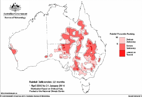
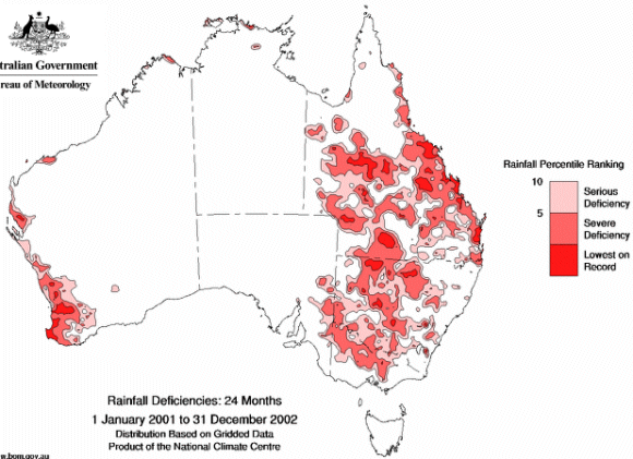
From the BoM Drought page – Issued on 4 February 2014 by the National Climate Centre – Rainfall deficiencies increase in Queensland and adjacent New South Wales and South Australia
22 months of drought April 2012 to Jan 2014
Compared to 24 months of drought Jan 2001 to Dec 2002
wahroongafarm:
I notice you carefully left out the worst drought recorded in Australia since settlement (and indications of worse one previously).
(Australian) Farm GDP, in chain volume measures, rose 0.8 per cent in the December quarter to be up 12.2 per cent in the 12 months to December.
www.news.com.au/finance/economy/australian-gdp-rose-08-in-the-december-2013-quarter/story-e6frflo9-1226845769749
A 12% increase in farm products volume over 12 months certainly doesn’t indicate general problems in the agricultural sector. Rather it indicates farmers overall are doing very well with any adverse weather effects limited and most experiencing beneficial weather conditions.
Note chained volume isn’t a Year on Year measure. It’s change from an average calculated over a number of years. My point still applies.
As you commented on the satellites thread –
Queensland’s largest drought-declared area ever –
www.abc.net.au/news/2014-03-07/qld-drought–most-widespread-ever-recorded/5306044
now go to this BoM drought map and I will walk you through the various time periods.
www.bom.gov.au/jsp/awap/rain/index.jsp?colour=colour&time=latest&step=0&map=drought&period=3month&area=nat
3 months – drought only in SE Qld.
6 months – patchy drought in less than half of southern Qld –
9 months – drought increased but mainly in southern Qld –
12 months – less drought than 9 months –
18 months – drought worse over less than half of Qld –
24 months – much less drought, mainly in south –
36 months – almost no drought over Qld.
The claim of “Queensland’s most widespread on record,…” in the ABC article is bizarre. As is their confusing the idiot Qld Govt maps with drought. When all they are is areas where rural subsidies are being paid.
The BoM maps tell you where drought is by their measuring of rainfall over various time periods.
Did Qld Minister John McVeigh really say as quoted by ABC – “February, normally one of the wettest times of the year, has been particularly dry.”
Particularly dry!!! Just check the BoM rain percentage map for Feb 2014 above – over average rain over vast areas of Queensland. What information is Minister John McVeigh relying on?
This must be one of the worst Queensland droughts OFF the “record” below.
trove.nla.gov.au/ndp/del/article/61388336?zoomLevel=6
In SE Qld (includes Brisbane where parliament is located) the rainfall has been well below average for the last three months. I have recorded 26% of average. It is certainly not the lowest rainfall in that period. One could take the dry period back to Aug 13 which was well below average, Sep, Oct & Dec 13 were below average while Nov 13 above average. For the whole of 2013 the rainfall was well above average and there were floods in some areas in Feb 13.
The 2001 Bureau of statistics YEAR BOOK has some nice decadal anomaly maps showing the past 10 decades since federation 1900…100 yrs of DECADAL ANOMLAY MAPS
1931-1940 RAIN ANOMALIES
www.abs.gov.au/AUSSTATS/abs@.nsf/61cfc5401332ba40ca2570d60018db27/1d46b2e612b3af1eca2569de001f1082/Body/157.4808!OpenElement&FieldElemFormat=gif
source
Mid page
www.abs.gov.au/AUSSTATS/abs@.nsf/Previousproducts/1301.0Feature%20Article32001