A week or so ago my eye was caught by this headline – “Most Canadians should expect a green Christmas: Environment Canada” – and I thought – well they should know, they are the Canadian Weather Office.
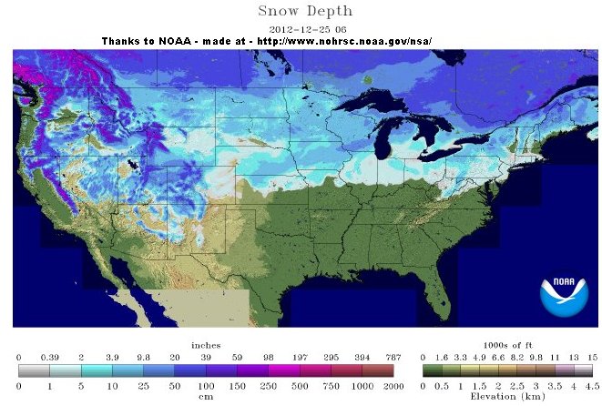
Now I see their forecast for 25 December 2012 looks like this –

and I am wondering if there is some parallel universe re temperature units in Canada. Perhaps readers can let us know how much green is around where “most Candians” live as we tick down to Christmas.
Maybe David Marshall will emulate Andrew Weaver from UVic and quit his cushy job, then run as a Green Party candidate in the next election. Has he written a scary book? I suspect this may become an attractive option as he’s certainly placed himself in the gunsights of the current government (who have shown little tolerance for pseudoscience).
Looks like be the White Party …
I live about a 2 hour drive from Montreal. We got 50 cm. of snow in the last 2 days but Montreal got only rain and a few flakes.
The vast majority of Canadians live in the southern strip of our country so many may well miss their white Christmas but here, I had to shovel off the roof and we lost power for 36 hours (Covering 3 consecutive days according to the Mayan calendar so, technically, we had our 3 days of darkness 😉
As for Environment Canada, their weather forecasts have suffered greatly since they moved into a new building that doesn’t have any windows…
Hi Warwick, have a look and see what you can find here, the media are blaming a shark presence along WA coast to an ocean heat wave of up to 5C. pindanpost.com/2012/12/24/dopey-or-doped-up-not-the-sharks/
WOCN11 CWTO 241000
Special weather statement issued by Environment Canada at 5:00 AM EST
Monday 24 December 2012.
———————————————————————
Special weather statement for:
=new= City of Toronto
=new= Windsor – Essex – Chatham-Kent
=new= Sarnia – Lambton
=new= Elgin
=new= London – Middlesex
=new= Simcoe – Delhi – Norfolk
=new= Dunnville – Caledonia – Haldimand
=new= Oxford – Brant
=new= Niagara
=new= City of Hamilton
=new= Halton – Peel
=new= York – Durham
=new= Huron – Perth
=new= Waterloo – Wellington
=new= Dufferin – Innisfil
=new= Grey – Bruce
=new= Barrie – Orillia – Midland
=new= Belleville – Quinte – Northumberland
=new= Kingston – Prince Edward
=new= Peterborough – Kawartha Lakes
=new= Stirling – Tweed – South Frontenac
=new= Bancroft – Bon Echo Park
=new= Brockville – Leeds and Grenville
=new= City of Ottawa
=new= Gatineau
=new= Prescott and Russell
=new= Cornwall – Morrisburg
=new= Smiths Falls – Lanark – Sharbot Lake
=new= Parry Sound – Muskoka
=new= Haliburton
=new= Renfrew – Pembroke – Barry’s Bay
=new= Algonquin
=new= Burk’s Falls – Bayfield Inlet.
Potential winter storm boxing day into Thursday.
———————————————————————
==discussion==
Current indications suggest that a low pressure system will develop
over Texas on Christmas day and then move northeastward to pass south
of the Great Lakes region late in the day boxing day into Thursday.
Such a storm track would place Southern Ontario on the cold side of
the storm, with the potential for significant snowfall accumulations.
Present indications suggest that the snow would start in the
southwest during the day on boxing day, and then spread eastward to
reach Eastern Ontario later in the evening. In addition, gusty
northeast winds would result in local blowing snow reducing
visibilities. Conditions should improve from west to east on
Thursday.
It should be emphasized that this storm has yet to develop and the
track of the storm may alter. Thus it is still much too early to
forecast precipitation amounts. The public is strongly advised to
monitor future forecasts for more information regarding this
potential winter storm.
End
arctic.atmos.uiuc.edu/cryosphere/NEWIMAGES/arctic.seaice.color.004.png
Texas brew coming.
i22.photobucket.com/albums/b331/kevster1346/Texas_zps14414ed7.jpg
I wondered how the “Green Christmas” thing worked out for “most Canadians”.
Thanks to Anthony Watts.