EUGOWRA. MOST CLUELESS FLOOD
WARNING ON RECORD?
A relative emailed me about a house my
mother built having washed along Willbe street. In the interest of
improving flood warnings for Eugowra, a collection of amazing
historical lessons learned and lost. With sources and links where
possible.
There have been many successful warnings,
dramatic rescues and a multitude of prior large floods in Eugowra. A
look back in time shows a repeating pattern. Sudden, slow, damaging
and huge floods. Some with walls of water. Each revives the reality
in short term memory. A flood as high as the “1 in 5000 year
event” we have just supposedly had according to the ABC and
perhaps one or two higher. The history of old warning methods, large
evacuations and heroic rescues shows a repeating cycle of heroism and
forgetfulness. Prior walls of water a day apart, multiple huge floods
in the same week and the places where the water came from, all
forgotten again and again. How with the technology and data available
in 2022 were so many asleep and unaware? A knowledge of history is
far better than putting everything down to the unfathomable magic of
“climate change”.
Places recently thought safe
and marked on maps as not likely to flood on the eastern side of the
town in the “Newtown” area have actually been
flooded up to six times a year in the past.
History shows maintenance of an old ever changing flood diversion
plan to have been neglected several times and improved following
floods. History also shows where to watch for better warnings.
Eugowra is almost a nexus point of many tributary creeks to the
Mandagery creek and is not far from the passing Lachlan river.
Some
Cabonne shire maps can be seen here showing various flood map
details. From “Cabonne Settlement Strategy 2021-2041”.
A
note in the top left of the maps says: “This plan assumes that
the Puzzle Flat Creek levee will remove the overland flow flooding
east of Aurora St (to be confirmed by flood engineers).”
As
will be seen from many of the news reports below. The same assumption
was made in the past with different versions Puzzle Flat Creek
strategy each one meeting a flood it could not beat.
https://www.cabonne.nsw.gov.au/files/sharedassets/public/planning-and-development/settlement-strategy/b4.-css-eugowra-settlement-options-post-exh-may-2021.pdf
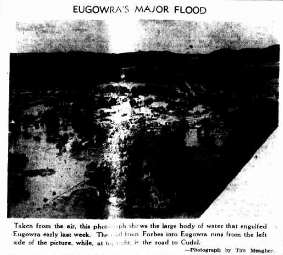
One
of three floods in the same week that hit Eugowra in October 1950. It
is not the April 1950 flood but one reported as being smaller.
The
Forbes Advocate Fri 3 Nov 1950 Page 6 “EUGOWRA'S MAJOR
FLOOD”.
https://trove.nla.gov.au/newspaper/article/219103748
Quotes from “Tom Boney’s” great swim. A
great read worth following the link to.
The Sydney Sunday Times
17 Dec 1916 on Page 22, “SAVED 13 LIVES”.
The true
story of "Boney" who in 1870 delivered the flood warning to
Eugowra and rescued 13 people by spending nine hours in the water
with his and other horses. A lot of that time not in contact with the
ground underneath. Escort rock is out of town on the north eastern
side of Eugowra.
“In the year 1870, on the banks of
the Lachlan, some miles above Forbes, stood the out station of
Eugowra, at that time owned by Mr. Andrew Clements. The homestead was
on the Orange side of Eugowra Creek, and in sight of the spot where
the gold escort was stuck up.” A little further along
in that. “He had just got news that floods higher than
any in the memory of white man were coming down. If that was true,
the O'Meallys would all be drowned before morning.” Further
along again, the seemingly impossible happens. Children on horses
with adults swimming. “The
first thing that met the eye of Joe M'Mahon as he looked out after
lighting his fire that morning, was a company of half-drowned people
coming in from what looked like an inland
sea.”
https://trove.nla.gov.au/newspaper/article/121345172
The
year 1950 had at least 6 floods in Eugowra. The
media today seem to be quoting 10.01 Meters as “The 1950 flood”
but which one of at least six 1950 floods was that?
This one
from April 1950 is recorded as 36 feet (10.97 Metres) by The Sydney
Morning Herald Tue 4 Apr 1950 Page 1 “RACE FROM FLOOD IN NIGHT
ATTIRE”.
“The waters in Eugowra rose to
36ft-more than three feet above the previous record level of
1926.”
That
would make the 1926 flood just under 10.05M.
"Almost
the entire population of about 800 had been evacuated and nearly
every house was under
water."
https://trove.nla.gov.au/newspaper/article/18154852
An
October 1950 flood is reported as 32 feet, 9.75 Meters.
The
Goulburn Evening Post Thu 26 Oct 1950 Page 5 “FLOODS IN
EUGOWRA”.
But this was not the flood
peak.
https://trove.nla.gov.au/newspaper/article/104326945
The
police were recorded as predicting the peak a day later than this
9.75M level.
The Melbourne Age Thu 26 Oct 1950 Page 6 “Township
Menaced by Lachlan Flood”.
“The worst flood
waters on record are expected at Eugowra early tomorrow morning.
Eugowra police issued urgent flood warnings this afternoon and
tonight.”
https://trove.nla.gov.au/newspaper/article/205374976
An
August flood is recorded at 30 feet.
The Forbes Advocate Fri 4
Aug 1950 Page 6. “EUGOWRA AGAIN SUFFERS FLOOD”
This
gives a clue to the old zero feet datum point.
“Mandagery
Creek Water Enters Several Homes. The Mandagery Creek at Eugowra
reached its peak at 30 feet early on Wednesday
morning,”
https://trove.nla.gov.au/newspaper/article/219102230
From
that possibly just under 10.05M 1926 flood a very common description
of how some floods affected the lower eastern part of the town. We
were told in a recent ABC television report by a local being
interviewed that her expectation was that the eastern side “never
floods”. Notice from the quote below that the water came from
the Canowindra rd on the eastern side not the down the Mandagery
creek or up from the Lachlan river.
Molong Express and Western
District Advertiser Sat 3 Apr 1926 Page 10 “EUGOWRA”.
A
huge flood came down the Canowindra Road, and banked up against the
railway line. The railway yard and a good portion of Newtown was a
sea of
water."
https://trove.nla.gov.au/newspaper/article/139392824
From
sometime after April 27 1926 the flood heights were measured by a
height gauge. Likely the datum point used from then on.
The
Forbes Advocate Tue 27 Apr 1926 Page 3. “Jottings”.
The
Eugowra Agricultural Bureau's request (through Mr. N. G. McMillan,
hon, sec.) for a flood, gauge to be erected at the bridge over the
Mandagery Creek at Eugowra, has been granted, by the Boree Shire
Council.
https://trove.nla.gov.au/newspaper/article/218640215
This
SES document on page 2 explains by use of a table the flood heights
in Eugowra.
It
gives the flood of April 1950 as 10.01M. It also has these important
words.
“Eugowra has a history
of flooding from Mandagery Creek and to a lesser extent from Puzzle
Flat Creek”
How
much lesser is that lesser extent? Is that lesser extent always
lesser? What about the other creeks?
https://www.ses.nsw.gov.au/media/1970/brochure-eugowra_floodsafe_guide.pdf
Mentioning
the flood height at Eugowra bridge going under water paints the
recent flood as a never before situation. This April 1950 flood
report from Eugowra shows
this
the flood gauge also going under the water back then.
The Forbes
Advocate Thu 6 Apr 1950 Page 6 “FLOOD WATERS RECEDE AROUND
EUGOWRA”
“With no
exception, every business house in Eugowra received damage from the
flood, which was the worst ever experienced in the Mandagery Creek.
The water 'was several feet deep in the centre of the main road
through the town, and even covered the traffic portion of the curved
cement bridge across the creek. The actual height of the flood can
not be judged, as the gauge, and the bridge to which It was attached,
was completely under water.” It
lasted a long time with at least two peaks. “As
late as 9 a.m. on Tuesday, water was still pouring through the show
window of Sparke's shop.” One
of the early peaks was reported at 8.5 Meters. This height was enough
to catch some by surprise. So it could indicate the old zero datum
point was higher. If the gauge is representative of where this
occurred and was reported correctly. The Monday peak was much higher.
“On Saturday night, the gauge on the
bridge recorded 28 feet. It fell on Sunday morning, and then began to
rise again on Sunday night. Some people moved their belongings to dry
ground when the first warnings of the flood were received, but
others, who took no notice of the warnings, were caught by the
swiftly rising current.” “WATER IN HOUSES Water rose into
houses In North Street early Sunday night, and as far as Ledger's
bakery in Broad Street an hour before it broke on the south side. It
then spread up between the Post Office and J. W. Lees' store at about
11.30 on Sunday night. The peak was reached on Monday morning, when
the depth of the water In the business houses ranged from six inches
to four
feet.
https://trove.nla.gov.au/newspaper/article/218700564
The
above mentioned other bridge that went completely under would have
been part
of the
old
wooden bridge that was still there in the early 1970s. After it was
finally removed sometime around 1975. When I lived there and nearby.
I can remember talking to an elderly German couple, Erica and Lloyd
Malt who lived in a house right near it that is no longer there. The
house was raised on stilts like the old Queenslander and protected by
a flood wall. They needed to go up stairs to what would be the
equivalent of the second story to enter. It was right close to the
Mandagery creek on what is now Myall St Park. He was sure that when
the old bridge was removed that the height gauge had been replaced at
a different height.
A flood wall at the front of this house can
just be seen in the 1973 photo
here.
http://www.bonzle.com/c/a?a=featuredpics&sz=4&fn=88ylngwv&or=3&pg=0&yr=1973&mo=91772837
There
remains however an alternate flood height Gauge that can confirm the
April 1950 flood as being around 36 feet(11M). It is more stable than
an ABC journalist and less likely to be deleted than BoM or N.S.W.
government data. That is the concrete bridge itself. It is described
as having the road surface covered in 1950. This can be compared to
the height reached by the recent flood as shown by the marked tree in
the ABC television reports.
The old flood height gauge
would have been used to determine this 1946 child risk at 35
feet.
The Forbes Advocate Fri 15 Mar 1946 Page 8 OUR
BRIDGE.
“Recently the writer
crossed the new bridge at Eugowra and noticed a small pair of shoes,
blocking one of the apertures that exist in the concrete sides of the
structure. Closer Investigation revealed the legs of a five year old
lad, who had crawled through the opening and was balancing on the
outer rim to watch the activities of other youngsters playing in the
bed of the creek some 35 feet
below.”
https://trove.nla.gov.au/newspaper/article/218408207
The
concrete bridge was opened in January 1942.
The Forbes Advocate
Fri 30 Jan 1942 Page 4. Eugowra's Big Day.
https://trove.nla.gov.au/newspaper/article/219516605
However
this report from 1942 shows the “lower part of town”,
which would be the now less inhabited older part of the south west,
went under well before the bridge.
Molong Express and Western
District Advertiser Fri 26 Jun 1942 Page 12 EUGOWRA
“Eugowra
township awakened on Saturday morning to find the water breaking over
the banks. In no time the lower end of the town was inundated several
feet in
depth.”
https://trove.nla.gov.au/newspaper/article/140107433
This
1920 flood likely had a much lower flood height at the Mandagery
creek bridge but again shows the alternate source of floods from the
east.
Parkes Western Champion Thu 8 Jan 1920 Page 9
A
cloudburst occurred on the Canowindra road, about 4 miles east of
Eugowra. It is estimated that at least 5 or 6 inches of rain fell in
a few minutes. A torrent of water a foot deep and about a quarter of
a mile wide swept over the racecourse towards the town. Newtown was
completely isolated by a foot deep of water for several hours and the
place presented a unique
spectacle.
https://trove.nla.gov.au/newspaper/article/113483945
From
November 1950 an explanation of the Canowindra road problem
returning.
The Forbes Advocate Fri 1 Dec 1950 Page 6 SAME
TROUBLE 20 YEARS AGO
“Canowindra
Road Caused Eugowra Floodings According to a resident of the area, a
silted up drain near the Canowindra road was responsible for damage
being caused during this year's floods at Eugowra “As
you probably are aware, the eastern end of Eugowra has, during
the last few months, been badly flooded on at least six occasions
from the Canowindra road," wrote
Mr. R. A. Douglas, of Eugowra, in a letter to last week's meeting of
the Boree Shire Council.”These floodings
entered house yards, doing much damage I should know, as I own
property in Oberon Street. Twenty years ago we had the same trouble
and the then Council cleaned out and put a drain running from the
culvert in front of Mr. C. Brien's gate on the Canowindra
Road.”
https://trove.nla.gov.au/newspaper/article/219101904
The
“same trouble twenty years ago” could perhaps be this one
but there must be something wrong with this 1931 report.
The
Forbes Advocate Fri 29 May 1931 Page 1 LATEST REPORTS
"A
report from Eugowra states that the Mandagery Creek Is 40 feet high
and rising".
40 feet is 12.2 meters. A one in forty billion year event? No it was
still
rising.
https://trove.nla.gov.au/newspaper/article/218420748
The
flood “twenty years ago” does not appear to be this one.
Why they are debating third or second here below could be because the
May flood was the obvious winner but was it really? I doubt
it.
Molong Express and Western District Advertiser Sat 4 Jul
1931 Page 9 EUGOWRA.
“Old hands
say that the flood on Thursday of last week was the third highest on
record the present generation, says it was the second
highest.”
https://trove.nla.gov.au/newspaper/article/139674252
The
40 feet figure is suspect because that May 1931 flood is reported
here at the other stable and unlikely to be deleted flood gauge to
have only made it up to. The 1927 imperial theatre building.
The
Forbes Advocate Fri 3 Jul 1931 Page 3 EUGOWRA
“The
western end of the. Shopping area was cut off by the creek over flow
about 10 a.m., and most of the houses In that part were under three
to five feet of water. The overflow backed up as far as the Imperial
Theatre.”
https://trove.nla.gov.au/newspaper/article/218427275
The
imperial theatre reports quite differently from April 1950.
The
Forbes Advocate Fri 14 Apr 1950 Page 3 “Mandagery Flood
Understated”.
“The
picture show proprietor told me he had removed seven tons of mud from
the theatre. There are very few buildings in the town which have not
been
flooded.”
https://trove.nla.gov.au/newspaper/article/218698644
This
one from 1934 does fit the “20 years ago” pattern but is
obviously under twenty years.
Parkes Western Champion Fri 2 Feb
1934 Page 1 “Torrential Rain Eugowra Suffers Enormous
Damage”.
“Torrential rain
fell through the district on Tuesday afternoon the 4&1/2 inches
registered in Eugowra falling in 2&1/2 hours. The huge watershed
up the Canowindra Road was simply deluged, and a roaring mass of
water poured out of the hills and down Traves Valley, taking every
thing in front of it. Newtown in Eugowra was a swirling torrent of
water, nearly every house being flooded. At the railway rescue
parties were waist deep in water. The railway line on the Goolagong
side was washed away in several places, one big culvert disappearing.
The mall train from Eugowra had to return, and passengers had to
spend the night at the railway station, where they were marooned from
town.”
https://trove.nla.gov.au/newspaper/article/219101904
This
1928 flood rose quickly but did most damage to the immediate
Mandagery creek area and the Western side of town. Newtown, the
Canowindra rd and the railway are not mentioned.
“Although
telephone messages kept coming through that the flood was a record
one higher up, no precautions were taken, as it was considered they
were only alarmist reports. At 6 p.m. it could be. Seen that the
flood would be a big one, but still shopping went briskly on.”
Just
an hour and a half or so later people found themselves and their cars
were trapped.
“all the town on
the western end of the bridge was a raging tornado”
...“Twenty-two women and children spent the night on the roof
of P. Week's house and some more on the roof of the Imperial
Theatre.”
https://trove.nla.gov.au/newspaper/article/139472885/16142724
A
week after the above 1928 flood, a small flood shows how suddenly the
eastern side of the town could have it’s own separate problem.
Orange Leader Fri 2 Mar 1928 Page 6 EUGOWRA.
“On
Friday afternoon, there was a cloud burst on the eastern end of the
town, and no one would believe there was a flood coming. However, It
was not long before a wall of water could be seen coming down the
Canowindra road, and over part of the showground. A number of houses
in Newtown were surrounded by water a few Inches Deep, but it passed
away as quickly as it
came."
https://trove.nla.gov.au/newspaper/article/254408987
A
report of a 1924 flood in eastern Eugowra follows the familiar
pattern repeated through history again and again.
Parkes
Western Champion Thu 27 Nov 1924 Page 11 “Eugowra”.
“A
huge flood came down the Canowindra road, doing a lot of damage to
the road. Newtown felt the full force of the flood, most of the
houses being flooded out. The water was up to the floors and totally
surrounded the houses in some cases. The viaduct in the railway yard,
built to carry any excess water, failed, to do its duty, with the
result that the yards were badly flooded, and some of the new wheat
stacking sites were almost
covered.”
https://trove.nla.gov.au/newspaper/article/113497291
In
1936 the now seemingly forgotten answers to the Canowindra road
sudden flood riddle began to appear more clearly. The water was
coming from Puzzle Flat and Puzzle Flat creek. The article details a
complicated water diversion plan.
Molong Express and Western
District Advertiser Sat 19 Sep 1936 Page 14.
“..
the water came from a depression further north which collected the
water from the hills on the north side of Puzzle Flat, as well as
some of the water from Puzzle Flat Creek, that could not pass through
the bridge in the main road.”...“They also suggested that
the street adjacent to the showground running north and south be
re-formed and the road will be raised considerably to cause any water
that came down through the showground to be diverted toward the
railway
culvert.”
https://trove.nla.gov.au/newspaper/article/141078205
Before
the modifications to the flow from Puzzle Flat and Puzzle creek, one
of the main issues
was
where the creek met the railway. This report from 1925 shows how the
eastern part of Eugowra could flood without the western part
flooding.
Molong Express and Western District Advertiser Sat 27
Jun 1925 Page 10 “EUGOWRA".
“Another
18 inches, and all the western portion of the town would have been
inundated. Terrific rain fell here on Saturday and Saturday night and
part of the next day, estimated at 7 inches. Early on Sunday morning
residents in the Newtown part of Eugowra realised that they were
going to be flooded out. A huge quantity of water had come down over
the race-course and steadily backed up against the railway until the
whole of Newtown was covered from a foot to 3 feet deep. Just when
things were looking serious the railway gave away, and the railway
yards became a lake several feet
deep.”
https://trove.nla.gov.au/newspaper/article/136797945
There
are many more reports of modifications and maintenance to the water
diversions to stop the flow of water from the Canowindra road, Puzzle
creek etc from flowing into Eugowra. As this report from 1952 shows
the plan did not always work.
The Forbes Advocate Fri 25 Jul
1952 Page 8 “MINOR FLOOD AT EUGOWRA”
“New
Town again had its flood from the Canowlndra Road and quite a few
streets up that way were covered with water for a couple of
days.”
https://trove.nla.gov.au/newspaper/article/219115323
Another
1952 flood a month earlier is recorded as 5 feet less than the 36
foot April 1950 flood. The warnings worked well and the height gives
clues to the flood gauge height in relation to the “light”
flooding then.
The Forbes Advocate Tue 24 Jun 1952 Page 6 “LIGHT
FLOODING AT EUGOWRA”.
“Warning
of the flood was received on Sunday night and all residents and
shopkeepers in the danger areas were well prepared. The water broke
the bank behind Nlven's house early In the morning and began running
down the gutters near the bridge about mid-day. One house, Welsh's,
In North Street, and some at the lower end of Broad Street were
flooded. The peak was reached on Monday night, the reading at the
bridge being Just over 31
feet”
https://trove.nla.gov.au/newspaper/article/219107091
After
so many floods in 1950 the newspapers get to know the routine.
The
Forbes Advocate Fri 27 Oct 1950 Page 12. Eugowra's Third Flood In
Seven Days.
“Always, after
heavy rain, Canowindra Road on the outskirts of the town becomes a
watercourse, and on Friday water from this vicinity poured down the
gutters and roadways right across that end of the town. Oberon
and Evelyn Streets and all cross streets were affected right across
to Wilbe Street, where Archer's, Slavin's, and Riach's residences
were surrounded.”
https://trove.nla.gov.au/newspaper/article/219097614/24259871
PMG
warnings.
It
is clear that warnings should take into account the rainfall that
ends up coming down Puzzle Flat creek. Warnings in the past apart
from that direction worked mainly via telegraph and telephone.
This
report from 1918 shows the plan becoming official.
The Forbes
Advocate Tue 29 Jan 1918 Page 2 “EUGOWRA'S FLOOD NEWS”.
“...the
Deputy Postmaster General, Sydney, reports that arrangements have
been made for Cowra and Canowindra to advise Eugowra of any heavy
rains and threatened floods, and that such advice will be immediately
posted out side the latter office for the information of the public.”
https://trove.nla.gov.au/newspaper/article/100304053
The
first of two 1942 floods in under a month show that the PMG, phone it
through, warning method had expanded to include the Mandagery creek
and was still working 22 years later.
The Forbes Advocate Fri 26
Jun 1942 Page 4 THE FLOOD.
“Word
came through from Murga about 920 a.m. that the flood was at Its
highest there, and could be expected to be at its highest at Eugowra
about 11 o'clock, but an hour or so before that time the creek
overflowed in several places, and by the time It was In full flood
several residences in the lower end of North Street had three or four
Inches of water running through them. Luckily, this was anticipated,
and all the furniture and belongings of the owners had been moved to
higher ground.”
The
writer of that points out that the width of the new bridge will
help.
https://trove.nla.gov.au/newspaper/article/219516666
The
second 1942 flood within a month shows the PMG warning method working
from further up the Mandagery creek.
The Forbes Advocate Fri 17
Jul 1942 Page 4 SECOND FLOOD WITHIN A MONTH.
“The
Eugowra residents received an other scare last Saturday, when they
received word from Manildra to expect another flood much bigger than
the last one a month ago. Although the Mandagery was a foot higher at
Murga than the previous one. It was several inches lower
here.”
https://trove.nla.gov.au/newspaper/article/219508963
This
August flood report from 1950 shows a possible change to the police
handling the warnings.
Daily Advertiser Wed 2 Aug 1950 Page 1
Flood-Weary Forbes Faces Another Deluge.
“Eugowra,
All the residents of the small township are hastily making their way
to high ground. Police think surging floodwaters will engulf every
building in the town. In April water was above the rooftops of homes
in
Eugowra.”
https://trove.nla.gov.au/newspaper/article/145598258
Both
of these 1959 reports show the police looking after successful early
warnings and also show Eugowra being hit by walls of water two days
in a row.
The Canberra Times Fri 3 Apr 1959 Page 3 WIDESPREAD
FLOODING IN N.S.W.
https://trove.nla.gov.au/newspaper/article/128812087 The Canberra
Times Sat 4 Apr 1959 Page 3 TOWNSPEOPLE BUILDING FLOOD WALL.
https://trove.nla.gov.au/newspaper/article/128812212
Reports
of floods from early Eugowra are numerous. The details not always
useful. Eastern Eugowra is mentioned in this 1905 report.
Cowra
Guardian and Lachlan Agricultural Recorder Sat 18 Feb 1905 Page 2
“EUGOWRA”.
“A heavy
storm at Chesher's farm, two miles from Eugowra, on Wednesday flooded
the whole place and swept fences away. Continuing its course, the
water swept over East Eugowra. flooding several of the houses, in
Eugowra only 75 paints
fell.”
https://trove.nla.gov.au/newspaper/article/261820566
1900
again shows the flood rescue methods in Eugowra vary from
resourcefulness to resourcefulness.
The Canowindra Star Fri 20
Jul 1900 Page 5 “Family Notices”
“MR.
and MRS. OSWALD NASH desire to convey their sincere thanks to those
people of Eugowra who so kindly constructed a boat and came to their
rescue during the recent flood; more especially to those who at the
risk of their own lives crossed at night in the boat to their
assistance. Willow Bank, 14th July, 1900.
Eugowra.”
https://trove.nla.gov.au/newspaper/article/143911887
Going
back to around 1815, 1817 the reports get a bit sketchy, as do
mine.
The Peak Hill Express Fri 22 Mar 1907 Page 17 “A
Relic.”
“This
tree stood as the record of exploration furthest west for almost two
vears until Surveyor Oxley, who made it his starting point, went
still further down the Lachlan River, was blocked by flood waters,
and reported an inland
sea.”
https://trove.nla.gov.au/newspaper/article/107206822
Jokes
about an inland sea aside, the whole area must be always going
through ongoing change. The trees in Mandagery creek grow taller and
fat. The mud and silt deposited in drains and the Imperial theatre
show that it will change the terrain a little each time. Roads, flood
levees, billabongs, the railway, and even the exact course of creeks
and rivers will be nothing like 200 years ago let alone 5000. With or
without the flood height gauge having moved from a wooden bridge to
the creek bank or water flow around buildings being in different
places, the idea that a 1 in 5000 year event could even be calculated
is even more sketchy than the idea of an 1817 inland sea.
Back
to 2022. The skilled hydrologist is required. The skilled forecaster
is also required. Neither of those are me. I studied electronics but
it is obvious that for better warnings in Eugowra rainfall over the
creeks that can deliver large amounts of water quickly should be
monitored, especially Puzzle Flat creek. The warnings based on the
time it takes water to travel down the Lachlan river can be slow. The
clues from the Belabula are part of that and of rainfall but it does
not flow through Eugowra. Warnings from upstream along the Mandagery
have in the past been very useful.
My uneducated
suggestion is human attention be paid as soon as a flood looks
possible. Regardless of who looks a human is required. In the age of
automatic tellers, self checkouts and robodept a skilled forecaster
may have been able to see what the computer models could not. Not
just because the Eugowra rain gauge was not working since early
November but because a human could look to alternative sources of
local information.
One problem for the computerised model
predictions is the lack of fine detail over the area’s that
matter. A lack of 4D geospacial fine definition in the Isohyetal
areal precipitation dynamics.
That tecno prattle blah blah,
somewhat explained here. Eugowra, being almost a nexus point of many
tributary creeks to the Mandagery creek and not far from the passing
Lachlan river, only needs the passing waters to synchronise for
flooding. When flood water comes past along the Lachlan from Cowra
and down the Lachlan via the Belabula from Canowindra the water from
Mandagery creek can only join it. It has nowhere else to go. When the
creeks by chance deliver flood water from near and far all at the
same time as the rivers bring it past, the level and action can only
go up.
https://www.weather.gov/abrfc/map
It
might also be good to lose the endless cycle of misplaced faith in
the most recent flood mitigation plan in combination with losing the
well funded politically driven amnesia. A skilled forecaster or even
a long term local well versed in history could have looked at this
Yeoval rain radar and developed a strong hunch. When the waters of
the Lachlan are high going past and the Mandagery are high coming
down, what happens next when the water from a randomly positioned
cloud burst that does not hit a rain gauge, has nowhere to go. The
outcome of a flood prediction could well depend on a short cloud
burst over the Nangar national park, Puzzle Flat or Long Gully. It
may not be as accurate but gives some of what the forecaster may need
to rapidly warn. Every five minutes this page updates. There are
5Min. 1Hour etc rainfall links to investigate.
http://www.bom.gov.au/products/IDR963.loop.shtml#skip
Lance
Pidgeon